|
|
|
0 members (),
2,752
guests, and
21
robots. |
|
Key:
Admin,
Global Mod,
Mod
|
|
S |
M |
T |
W |
T |
F |
S |
|
|
|
1
|
2
|
3
|
4
|
5
|
|
6
|
7
|
8
|
9
|
10
|
11
|
12
|
|
13
|
14
|
15
|
16
|
17
|
18
|
19
|
|
20
|
21
|
22
|
23
|
24
|
25
|
26
|
|
27
|
28
|
29
|
30
|
|
|
|
|
There are no members with birthdays on this day. |

Small magnitude 3.6 earthquake strikes near Great Falls, Cascade County, Montana, USA
• Volcano earthquake report for Friday, 18 September 2026
• Possible earthquake reported minutes ago near Great Falls, Montana, USA
• Magnitude 4.6 earthquake strikes near Ponce, Segundo Barrio, Ponce Municipi...
• Small magnitude 3.4 earthquake strikes near Skegness, Lincolnshire, England...
• World Earthquake Report for Friday, 18 September 2026
|

#751248
Wed 15 Jan 2025 07:19:PM
|
Joined: Feb 2001
Posts: 678,977
Launch Director
|
|
Launch Director
Joined: Feb 2001
Posts: 678,977 |
SPC Jan 15, 2025 1930 UTC Day 3 Severe Thunderstorm OutlookSPC 1930Z Day 3 Outlook 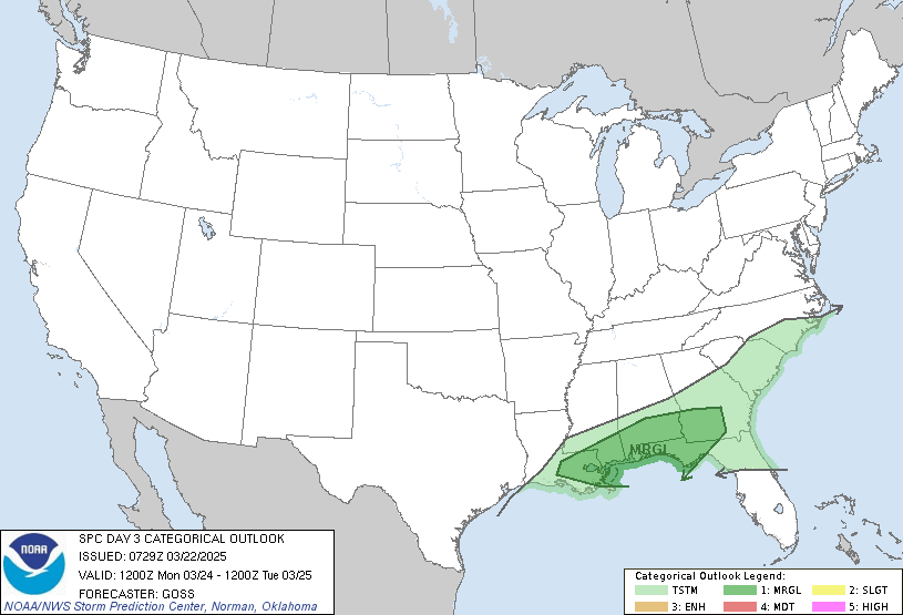
Day 3 Convective Outlook
NWS Storm Prediction Center Norman OK
0118 PM CST Wed Jan 15 2025

Valid 171200Z - 181200Z

...NO SEVERE THUNDERSTORM AREAS FORECAST...

...SUMMARY...
Isolated thunderstorms are possible during the evening and overnight
hours across the Lower Mississippi and Tennessee Valleys and central
Gulf Coast region Friday night and early Saturday morning.

...Synopsis...
An upper trough extending from a low moving into/across western
Ontario, will continue advancing southeastward across the Plains.
This trough will begin to partially phase with a second trough
shifting east across the Desert Southwest toward the southern
Plains.

In tandem with the Canadian upper low, a deep surface cyclone is
forecast to cross Ontario, reaching the James Bay vicinity
overnight.  A strong/trailing surface cold front will advance across
central portions of the U.S., reaching a position from the Upper
Great Lakes south-southwestward to the Lower Mississippi Valley
Saturday morning.

...Lower Mississippi/Tennessee Valleys to the Florida Panhandle...
As a cold front shifts southeastward toward/into the Lower
Mississippi and Tennessee Valleys late in the period, low-level
theta-e advection atop a cool/stable boundary layer will lead to
modest elevated destabilization.  This will likely be sufficient to
permit evolution of isolated thunderstorms, within a
broader/developing area of convection.  At this time, with the
stable boundary layer precluding appreciable surface-based storm
potential, and modest CAPE above, it appears that storms will remain
weak/disorganized, and thus sub-severe, despite an otherwise
favorable kinematic environment.

..Goss.. 01/15/2025
Read morehttps://www.spc.noaa.gov/products/outlook/day3otlk_1930.html
|
|



CMS The Best Conveyancing solicitors conveyancing quotes throughout the UK
For any webhosting enquiries please email webmaster@aus-city.com
|
|
Forums60
Topics830,396
Posts865,190
Members2,960
| |
Most Online102,106
Jul 10th, 2026
|
|
|
|
|

|





































