|
|
|
0 members (),
335
guests, and
21
robots. |
|
Key:
Admin,
Global Mod,
Mod
|
|
S |
M |
T |
W |
T |
F |
S |
|
|
|
|
|
1
|
2
|
3
|
|
4
|
5
|
6
|
7
|
8
|
9
|
10
|
|
11
|
12
|
13
|
14
|
15
|
16
|
17
|
|
18
|
19
|
20
|
21
|
22
|
23
|
24
|
|
25
|
26
|
27
|
28
|
29
|
30
|
31
|
|
There are no members with birthdays on this day. |

#758847
Tue 25 Mar 2025 08:01:PM
|
Joined: Feb 2001
Posts: 381,904
Launch Director
|
OP

Launch Director
Joined: Feb 2001
Posts: 381,904 |
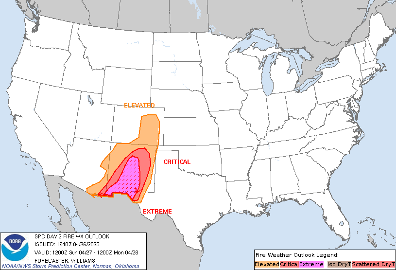
SPC Day 2 Fire Weather OutlookSPC Day 2 Fire Weather Outlook 
Day 2 Fire Weather Outlook
NWS Storm Prediction Center Norman OK
0259 PM CDT Tue Mar 25 2025

Valid 261200Z - 271200Z

...Appalachians...
An Elevated area has been added for areas near/east of the Blue
Ridge into parts of the Carolina Piedmont. Post-frontal downslope
flow will result in RH dropping to near critical thresholds, with
sustained wind speeds approaching 15 mph (with stronger gusts).
Light to locally moderate rainfall on D1/Tuesday may result in a
local minimum of threat across parts of central VA, within the
larger Elevated area.

...New Mexico and vicinity...
A small southwestward expansion has been made to the Isolated Dry
Thunderstorm area, but otherwise the previous reasoning remains
valid. See the previous discussion below for more details.

..Dean.. 03/25/2025

.PREV DISCUSSION... /ISSUED 0215 AM CDT Tue Mar 25 2025/

...Synopsis...
Large-scale ridging will continue to amplify over the western US as
a subtle southern stream shortwave trough slides underneath the
ridge. Weak ascent will overspread parts of the Southwest as modest
moisture returns to the west. This may support isolated dry
thunderstorms atop dry fuels in parts of the Southwest.

...Parts of NM...
As the weak upper-level trough moves over the Southwest, modest
ascent and easterly upslope flow is expected to promote isolated to
widely scattered showers and thunderstorms from central NM to
western TX. At the western extent of the moist plume, PWAT values
less than 0.75 inches will overlap with sufficiently steep low and
mid-level lapse rates to support high-based storms with poor
precipitation efficiency. Dry lightning strikes appear likely over
very receptive fuels given the high-based nature of any convection
that forms. An Isolated Dry Thunder area has been added across
western and central NM where best overlap of thunderstorm potential
and dry fuels should exist for several hours Wed.

...Appalachians...
Another day of dry conditions is expected across the southern
Appalachians Wed. High pressure will gradually shift eastward with
downslope flow likely across parts of western VA and the Carolinas.
While surface winds may not be overly strong (generally less than 15
mph), isolated gusts near 20 mph are possible. In addition,
afternoon RH should fall below 25%. Model guidance shows
considerable spread regarding the spatial and temporal coverage of
any elevated fire weather conditions that may develop. A few hours
of locally elevated fire-weather conditions are possible, but
uncertain.

...Please see www.spc.noaa.gov/fire for graphic product...
Read morehttps://www.spc.noaa.gov/products/fire_wx/fwdy2.html
|
|


CMS The Best Conveyancing solicitors conveyancing quotes throughout the UK
For any webhosting enquiries please email webmaster@aus-city.com
|
|
Forums60
Topics725,625
Posts760,241
Members2,958
| |
Most Online4,158
Jun 21st, 2024
|
|
|
|
|
Copyright 1996 - 2024 by David Cottle. Designed by David Bate Jr. All Rights Reserved.
By using this forum, the user agrees not to transfer any data or technical information received under the agreement, to any other entity without the express approval of the AUS-CITY Forum Admins and/or authors of individual posts (Forum Admins and DoD/USSPACECOM for the analysis of satellite tracking data).
Two-line elements (TLE) and all other satellite data presented and distributed via this forum and e-mail lists of AUS-CITY are distributed with permission from DoD/USSTRATCOM.


Reprise Hosting


|

|