|
|
|
0 members (),
940
guests, and
21
robots. |
|
Key:
Admin,
Global Mod,
Mod
|
|
S |
M |
T |
W |
T |
F |
S |
|
|
|
|
1
|
2
|
3
|
4
|
|
5
|
6
|
7
|
8
|
9
|
10
|
11
|
|
12
|
13
|
14
|
15
|
16
|
17
|
18
|
|
19
|
20
|
21
|
22
|
23
|
24
|
25
|
|
26
|
27
|
28
|
29
|
30
|
|
|
|
There are no members with birthdays on this day. |

#760552
Tue 15 Apr 2025 12:55:AM
|
Joined: Feb 2001
Posts: 381,904
Launch Director
|
OP

Launch Director
Joined: Feb 2001
Posts: 381,904 |
SPC MD 451MD 0451 CONCERNING SEVERE THUNDERSTORM WATCH 138... FOR EASTERN KENTUCKY...SOUTHERN WEST VIRGINIA...AND FAR WESTERN VIRGINIA 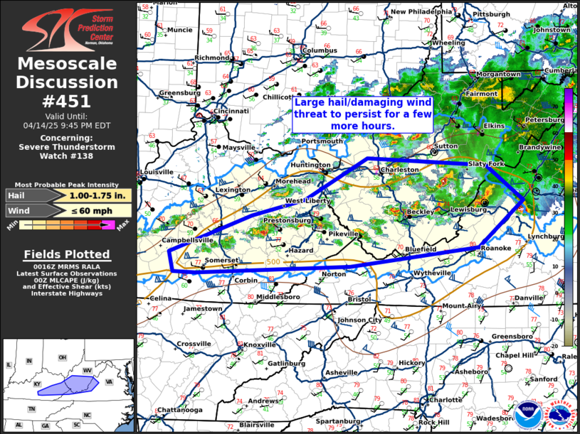
Mesoscale Discussion 0451
NWS Storm Prediction Center Norman OK
0718 PM CDT Mon Apr 14 2025

Areas affected...eastern Kentucky...southern West Virginia...and far
western Virginia

Concerning...Severe Thunderstorm Watch 138...

Valid 150018Z - 150145Z

The severe weather threat for Severe Thunderstorm Watch 138
continues.

SUMMARY...A large hail/damaging wind threat will persist for a few
more hours this evening.

DISCUSSION...A cluster of supercells across central West Virginia
has weakened over the past hour, but are still capable of some large
hail and damaging wind gusts for a few more hours. The greatest
threat will likely be with new development farther south and west
where a deeply-mixed airmass is present with greater instability.
However, even in this area the threat will likely only persist for a
few more hours given the loss of daytime heating.

..Bentley.. 04/15/2025

...Please see www.spc.noaa.gov for graphic product...

ATTN...WFO...LWX...RNK...RLX...MRX...JKL...LMK...

LAT...LON   37278519 37788380 38008289 38578182 38457979 37977916
            37357993 37098212 36998474 37008512 37278519

MOST PROBABLE PEAK WIND GUST...UP TO 60 MPH
MOST PROBABLE PEAK HAIL SIZE...1.00-1.75 IN
Read morehttps://www.spc.noaa.gov/products/md/md0451.html
|
|


CMS The Best Conveyancing solicitors conveyancing quotes throughout the UK
For any webhosting enquiries please email webmaster@aus-city.com
|
|
Forums60
Topics768,005
Posts802,769
Members2,958
| |
Most Online17,963
Jan 15th, 2026
|
|
|
|
|
Copyright 1996 - 2026 by David Cottle. Designed by David Bate Jr. All Rights Reserved.
By using this forum, the user agrees not to transfer any data or technical information received under the agreement, to any other entity without the express approval of the AUS-CITY Forum Admins and/or authors of individual posts (Forum Admins and DoD/USSPACECOM for the analysis of satellite tracking data).
Two-line elements (TLE) and all other satellite data presented and distributed via this forum and e-mail lists of AUS-CITY are distributed with permission from DoD/USSTRATCOM.

Reprise Hosting

|

|


 - Click image for larger picture.")


