|
0 members (),
1,211
guests, and
107
robots. |
|
Key:
Admin,
Global Mod,
Mod
|
|
S |
M |
T |
W |
T |
F |
S |
|
|
|
|
1
|
2
|
3
|
4
|
|
5
|
6
|
7
|
8
|
9
|
10
|
11
|
|
12
|
13
|
14
|
15
|
16
|
17
|
18
|
|
19
|
20
|
21
|
22
|
23
|
24
|
25
|
|
26
|
27
|
28
|
29
|
30
|
31
|
|
|
There are no members with birthdays on this day. |

World Earthquake Report for Sunday, 26 July 2026
• Moderate mag. 4.5 earthquake - Estado de Veracruz-Llave, Mexico, on 2026-07...
• Volcano earthquake report for Sunday, 26 Jul 2026
• Moderate mag. 4.0 earthquake - Kabupaten Kepulauan Talaud, 148 km northeast...
• Light mag. 3.9 earthquake - North Pacific Ocean, 65 km south of Puerto San ...
• Strong mag. 5.4 earthquake - Northern Mid-Atlantic Ridge on Sunday, Jul 26,...
|

#761610
Tue 29 Apr 2025 07:30:PM
|
Joined: Feb 2001
Posts: 678,976
Launch Director
|
OP

Launch Director
Joined: Feb 2001
Posts: 678,976 |
SPC Severe Thunderstorm Watch 191WW 191 SEVERE TSTM NY PA WV LE LO 291930Z - 300200Z 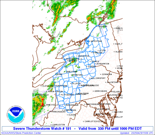
URGENT - IMMEDIATE BROADCAST REQUESTED
Severe Thunderstorm Watch Number 191
NWS Storm Prediction Center Norman OK
330 PM EDT Tue Apr 29 2025

The NWS Storm Prediction Center has issued a

* Severe Thunderstorm Watch for portions of
  Western and Northern New York
  Western and Central Pennsylvania
  Northern West Virginia
  Lake Erie
  Lake Ontario

* Effective this Tuesday afternoon and evening from 330 PM until
  1000 PM EDT.

* Primary threats include...
  Scattered damaging wind gusts to 70 mph likely
  Scattered large hail events to 1.5 inches in diameter possible
  A tornado or two possible

SUMMARY...Multiple lines and clusters of thunderstorms will traverse
the watch area through the afternoon and early evening.  The
strongest storms will pose a risk of damaging winds gusts and some
hail.

The severe thunderstorm watch area is approximately along and 80
statute miles north and south of a line from 15 miles west northwest
of Pittsburgh PA to 60 miles south southeast of Massena NY. For a
complete depiction of the watch see the associated watch outline
update (WOUS64 KWNS WOU1).

PRECAUTIONARY/PREPAREDNESS ACTIONS...

REMEMBER...A Severe Thunderstorm Watch means conditions are
favorable for severe thunderstorms in and close to the watch area.
Persons in these areas should be on the lookout for threatening
weather conditions and listen for later statements and possible
warnings. Severe thunderstorms can and occasionally do produce
tornadoes.

&&

OTHER WATCH INFORMATION...CONTINUE...WW 187...WW 188...WW
189...WW 190...

AVIATION...A few severe thunderstorms with hail surface and aloft to
1.5 inches. Extreme turbulence and surface wind gusts to 60 knots. A
few cumulonimbi with maximum tops to 500. Mean storm motion vector
24035.

...Hart
Read morehttps://www.spc.noaa.gov/products/watch/ww0191.html
|
|


CMS The Best Conveyancing solicitors conveyancing quotes throughout the UK
For any webhosting enquiries please email webmaster@aus-city.com
|
|
Forums60
Topics793,270
Posts828,053
Members2,960
| |
Most Online102,106
Jul 10th, 2026
|
|
|


 - Click image for larger picture.")


