|
|
|
0 members (),
593
guests, and
22
robots. |
|
Key:
Admin,
Global Mod,
Mod
|
|
S |
M |
T |
W |
T |
F |
S |
|
1
|
2
|
3
|
4
|
5
|
6
|
7
|
|
8
|
9
|
10
|
11
|
12
|
13
|
14
|
|
15
|
16
|
17
|
18
|
19
|
20
|
21
|
|
22
|
23
|
24
|
25
|
26
|
27
|
28
|
|
29
|
30
|
|
|
|
|
|
|
There are no members with birthdays on this day. |

#761620
Tue 29 Apr 2025 07:30:PM
|
Joined: Feb 2001
Posts: 381,904
Launch Director
|
OP

Launch Director
Joined: Feb 2001
Posts: 381,904 |
SPC MD 605MD 0605 CONCERNING SEVERE POTENTIAL...WATCH POSSIBLE FOR WESTERN PA/NY 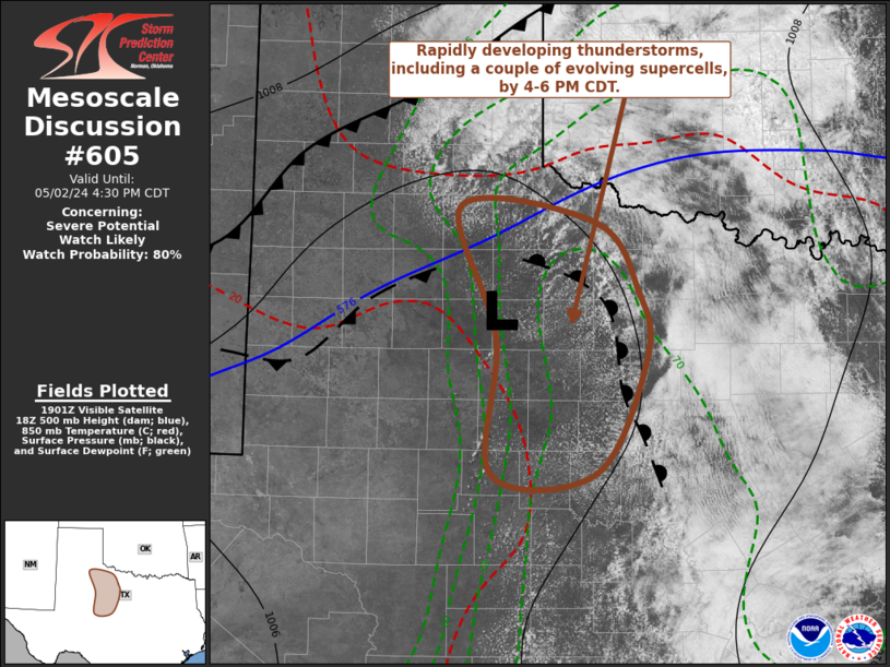
Mesoscale Discussion 0605
NWS Storm Prediction Center Norman OK
0141 PM CDT Tue Apr 29 2025

Areas affected...western PA/NY

Concerning...Severe potential...Watch possible

Valid 291841Z - 292045Z

Probability of Watch Issuance...60 percent

SUMMARY...Isolated to scattered thunderstorms are expected to
develop this afternoon and persist into the evening. Damaging gusts
will be the main hazard accompanying this activity. A watch may be
needed in the next 1-2 hours.

DISCUSSION...Persistent southwesterly low-level flow has allowed
surface dewpoints to increase by 2-6 degrees F over the past 3 hours
across much of the region, with values now in the upper 50s to low
60s F. Additionally, strong heating into the 80s has resulted in
steepened low-level lapse rates. Modest instability also is
overspreading the region, and a large area of cumulus is evident in
visible satellite imagery. Convection is expected to develop across
western NY over the next couple of hours ahead of the southeast
sagging cold front. Additional development may occur into western
PA. Additionally, an eastward propagating severe thunderstorm
cluster over central Ohio is also expected to persist. This cluster
is tracking east/northeast around 50-60 kt as should arrive at the
OH/PA border by 21z.

Unidirectional vertical wind profiles will continue to favor
clusters/line segments. Steep low-level lapse rates and a mixed
boundary layer will support damaging gusts. Modest midlevel lapse
rates could support isolated hail if any more discrete cells can
develop and be maintained. A severe thunderstorm watch may be needed
in the next 1-2 hours for portions of the MCD area.

..Leitman/Hart.. 04/29/2025

...Please see www.spc.noaa.gov for graphic product...

ATTN...WFO...BGM...BUF...CTP...PBZ...CLE...

LAT...LON   39957972 40048059 41688036 42048003 43187839 43477743
            43597659 43597614 43457579 43147542 42757569 41277732
            39957972

MOST PROBABLE PEAK TORNADO INTENSITY...85-115 MPH
MOST PROBABLE PEAK WIND GUST...55-70 MPH
MOST PROBABLE PEAK HAIL SIZE...1.00-1.75 IN
Read morehttps://www.spc.noaa.gov/products/md/md0605.html
|
|


CMS The Best Conveyancing solicitors conveyancing quotes throughout the UK
For any webhosting enquiries please email webmaster@aus-city.com
|
|
Forums60
Topics727,419
Posts762,035
Members2,958
| |
Most Online4,158
Jun 21st, 2024
|
|
|
|
|
Copyright 1996 - 2024 by David Cottle. Designed by David Bate Jr. All Rights Reserved.
By using this forum, the user agrees not to transfer any data or technical information received under the agreement, to any other entity without the express approval of the AUS-CITY Forum Admins and/or authors of individual posts (Forum Admins and DoD/USSPACECOM for the analysis of satellite tracking data).
Two-line elements (TLE) and all other satellite data presented and distributed via this forum and e-mail lists of AUS-CITY are distributed with permission from DoD/USSTRATCOM.

Reprise Hosting

|

|


 - Click image for larger picture.")


