|
|
|
0 members (),
1,811
guests, and
26
robots. |
|
Key:
Admin,
Global Mod,
Mod
|
|
S |
M |
T |
W |
T |
F |
S |
|
1
|
2
|
3
|
4
|
5
|
6
|
7
|
|
8
|
9
|
10
|
11
|
12
|
13
|
14
|
|
15
|
16
|
17
|
18
|
19
|
20
|
21
|
|
22
|
23
|
24
|
25
|
26
|
27
|
28
|
|
There are no members with birthdays on this day. |

#763905
Sat 31 May 2025 11:50:PM
|
Joined: Feb 2001
Posts: 381,904
Launch Director
|
OP

Launch Director
Joined: Feb 2001
Posts: 381,904 |
Volcano earthquake report for Saturday, 31 May 2025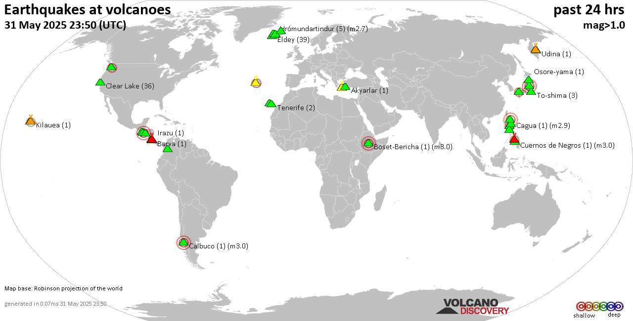 World map showing volcanoes with shallow (less than 50 km) earthquakes within 20 km radius during the past 24 hours on 31 May 2025 Number in brackets indicate nr of quakes. Quakes detected near: Abu (15 quakes between mag 0.1-2.0), Akyarlar (1 quake mag 1.1), Ambalatungan (1 quake mag 2.3), Arayat (1 quake mag 3.0), Barva (1 quake mag 1.6), Boset-Bericha (1 quake mag 3.0)
Cagua (1 quake mag 2.9), Calbuco (1 quake mag 3.0), Canlaon (1 quake mag 2.0), Clear Lake (36 quakes between mag 0.2-2.3), Coatepeque (1 quake mag 3.0), Cuernos de Negros (1 quake mag 3.0), Cuilapa-Barbarena (1 quake mag 3.0), Eldey (39 quakes between mag 0.1-2.1), Hrómundartindur (5 quakes between mag 0.3-2.7), Iraya (1 quake mag 3.4), Irazu (1 quake mag 1.5), Kilauea (1 quake mag 2.0), Klyuchevskoy (4 quakes between mag 0.9-1.6), Kolumbo (12 quakes between mag 1.2-2.6), La Palma (1 quake mag 1.5), Laguna Aramuaca (1 quake mag 2.5), Ljósufjöll (4 quakes between mag 0.9-1.5), Maunaloa (3 quakes between mag 1.4-2.0), Mount Rainier (2 quakes between mag 0.6-2.0), Numazawa (1 quake mag 3.0), Osore-yama (1 quake mag 1.1), Platanar (3 quakes between mag 1.3-2.0), Poas (2 quakes between mag 0.9-1.1), Prestahnukur (1 quake mag 1.1), San Diego (1 quake mag 1.1), Santorini (7 quakes between mag 0.7-2.1), Tenerife (2 quakes between mag 1.4-1.6), Terceira (1 quake mag 2.5), Tjörnes Fracture Zone (4 quakes between mag 1.0-1.1), To-shima (3 quakes between mag 1.0-2.4), Udina (1 quake mag 2.1), Ushkovsky (1 quake mag 1.7) (updated 23h50)
Note: Earthquakes within 20 km from and at depths less than 50 km under active volcanoes are reported. The list is not complete because many volcanoes are not monitored and/or seismic data in high resolution is not available publicly.
Volcanoes with recent earthquakes above magnitude 2 or more than 10 quakes are listed below:
Abu volcano (Honshu): 15 earthquakes up to magnitude 2.0Possible earthquake swarm: 15 earthquakes occurred near (under) the volcano during 9 hours, the last being recorded quake 1 hour 56 minutes ago. Hypocenter depths ranged between 26.40 and 23.80 km. Earthquake details: (only 5 largest) 2.0 quake 22 km northeast of Hagi, Yamaguchi, Japan, May 31, 2025 10:14 pm (GMT +9) (2 km NE) 1.3 quake 39 km north of Yamaguchi, Yamaguchi, Japan, Jun 1, 2025 06:54 am (GMT +9) (1 km NNE) 1.0 quake 39 km north of Yamaguchi, Yamaguchi, Japan, May 31, 2025 10:21 pm (GMT +9) (2 km NE) 0.9 quake 38 km north of Yamaguchi, Yamaguchi, Japan, May 31, 2025 10:48 pm (GMT +9) (2 km ENE) 0.8 quake 38 km north of Yamaguchi, Yamaguchi, Japan, Jun 1, 2025 01:02 am (GMT +9) (1 km ENE) All earthquakes at AbuAmbalatungan volcano (Luzon Island): magnitude 2.3 earthquakeA magnitude 2.3 earthquake occurred at the volcano 5 hours ago. The quake, which might be volcanic in origin, was located at a depth of 3.00 km depth at 13 km distance ESE from the volcano. Earthquake details: 2.3 quake 36 km southwest of Tabuk, Kalinga, Cordillera Administrative Region, Philippines, Jun 1, 2025 03:14 am (GMT +8) (13 km ESE) All earthquakes at AmbalatunganArayat volcano (Luzon Island): magnitude 3.0 earthquakeA magnitude 3.0 earthquake occurred at the volcano 18 hours ago. The quake, which might be volcanic in origin, was located at a depth of 10.00 km depth at 17 km distance W from the volcano. Earthquake details: Reported seismic-like event (likely no quake): 2.4 km north of Angeles City, Province of Pampanga, Central Luzon, Philippines, May 31, 2025 01:21 pm (GMT +8) (17 km W) All earthquakes at ArayatBoset-Bericha volcano (Ethiopia): magnitude 3.0 earthquakeA magnitude 3.0 earthquake occurred at the volcano 11 hours ago. The quake, which might be volcanic in origin, was located at a depth of 10.00 km depth at 0 km distance NNW from the volcano. Earthquake details: Reported seismic-like event (likely no quake): 23 km east of Nazret, Oromiya, Ethiopia, May 31, 2025 03:52 pm (GMT +3) (0 km NNW) All earthquakes at Boset-BerichaCagua volcano (Luzon Island): magnitude 2.9 earthquakeA magnitude 2.9 earthquake occurred at the volcano 15 hours ago. The quake, which might be volcanic in origin, was located at a depth of 6.00 km depth at 19 km distance SE from the volcano. Earthquake details: 2.9 quake Philippine Sea, 52 km south of Palaui Island, Philippines, May 31, 2025 04:37 pm (GMT +8) (19 km SE) All earthquakes at CaguaCalbuco volcano (Southern Chile and Argentina): magnitude 3.0 earthquakeA magnitude 3.0 earthquake occurred at the volcano 19 hours ago. The quake, which might be volcanic in origin, was located at a depth of 10.00 km depth at 9 km distance N from the volcano. Earthquake details: Reported seismic-like event (likely no quake): 36 km northeast of Puerto Montt, Llanquihue, Region de los Lagos, Chile, May 31, 2025 05:10 am (GMT +0) (9 km N) All earthquakes at CalbucoClear Lake volcano (California): 36 earthquakes up to magnitude 2.3Possible earthquake swarm: 36 earthquakes occurred near (under) the volcano during 22 hours, the last being recorded quake 2 hours ago. Hypocenter depths ranged between 10.31 and 0.70 km. Earthquake details: (only 5 largest) 2.3 quake 12 mi southwest of Clearlake, Lake County, California, United States, May 30, 2025 06:40 pm (GMT -7) (16 km S) 1.6 quake Sonoma County, 14 mi southwest of Clearlake, Lake County, California, United States, May 31, 2025 09:07 am (GMT -7) (16 km SSW) 1.5 quake 6 km WNW of Cobb, CA, May 30, 2025 06:41 pm (GMT -7) (15 km S) 1.3 quake Lake County, 26 mi north of Santa Rosa, Sonoma County, California, United States, May 31, 2025 07:46 am (GMT -7) (18 km S) 1.3 quake 10 km NNW of the Geysers, CA, May 31, 2025 08:46 am (GMT -7) (15 km SSW) All earthquakes at Clear LakeCoatepeque volcano (El Salvador): magnitude 3.0 earthquakeA magnitude 3.0 earthquake occurred at the volcano 9 hours ago. The quake, which might be volcanic in origin, was located at a depth of 10.00 km depth at 14 km distance ESE from the volcano. Earthquake details: Reported seismic-like event (likely no quake): 30 km northwest of San Salvador, Departamento de San Salvador, El Salvador, May 31, 2025 09:13 am (GMT -6) (14 km ESE) All earthquakes at CoatepequeCuernos de Negros volcano (Central Philippines): magnitude 3.0 earthquakeA magnitude 3.0 earthquake occurred at the volcano 18 hours ago. The quake, which might be volcanic in origin, was located at a depth of 10.00 km depth at 16 km distance ENE from the volcano. Earthquake details: Reported seismic-like event (likely no quake): 1 km southwest of Dumaguete, Philippines, May 31, 2025 02:16 pm (GMT +8) (16 km ENE) All earthquakes at Cuernos de NegrosCuilapa-Barbarena volcano (Guatemala): magnitude 3.0 earthquakeA magnitude 3.0 earthquake occurred at the volcano 15 hours ago. The quake, which might be volcanic in origin, was located at a depth of 10.00 km depth at 1 km distance NNW from the volcano. Earthquake details: Reported quake or seismic-like event: 9.3 km west of Guatemala City, Departamento de Guatemala, Guatemala, May 31, 2025 02:40 am (GMT -6) (1 km NNW) All earthquakes at Cuilapa-BarbarenaEldey volcano (Iceland): 39 earthquakes up to magnitude 2.1Possible earthquake swarm: 39 earthquakes occurred near (under) the volcano during 17 hours, the last being recorded quake 7 hours ago. Hypocenter depths ranged between 12.30 and 1.10 km. Earthquake details: (only 5 largest) 2.1 quake 4.4 km NNE of Geirfuglasker May 31, 2025 12:22 am (Universal Time) (8 km W) 1.9 quake 2.9 km NW of Eldey May 31, 2025 12:38 am (Universal Time) (3 km N) 1.8 quake 2.9 km NW of Eldey May 31, 2025 01:38 am (Universal Time) (3 km N) 1.8 quake 2.5 km NW of Eldey May 31, 2025 01:44 am (Universal Time) (3 km N) 1.7 quake Iceland: 6.0 km W of Eldeyjardrangur May 31, 2025 04:57 pm (Reykjavik time) (5 km W) All earthquakes at EldeyEldey is located at the beginning of the Reykjanes Ridge off the SW tip of Iceland. Its highest elevation is the top of Eldey Island, but most of the volcanic edifice is submerged. Several eruptions occurred in historic times, last in 1926. Hrómundartindur volcano (Iceland): 5 earthquakes up to magnitude 2.75 earthquakes occurred near (under) the volcano during 4 hours, the last being recorded quake 12 hours ago. Hypocenter depths ranged between 8.40 and 3.70 km. Earthquake details: 2.7 quake 3.6 km SW of Hrómundartindi May 31, 2025 07:46 am (Universal Time) (4 km SW) 1.0 quake Iceland: 3.7 km S of Hrómundartindi May 31, 2025 08:00 am (Reykjavik time) (3 km S) 0.4 quake Iceland: 5.7 km SSE of Hveragerði May 31, 2025 09:27 am (Reykjavik time) (14 km S) 0.3 quake Iceland: 2.1 km NNE of Hellisheiðarvirkjun May 31, 2025 11:56 am (Reykjavik time) (9 km WSW) 0.3 quake 3.7 km SW of Hrómundartindi May 31, 2025 07:48 am (Universal Time) (3 km SW) All earthquakes at HrómundartindurIraya volcano (North of Luzon): magnitude 3.4 earthquakeA magnitude 3.4 earthquake occurred at the volcano 1 hour 2 minutes ago. The quake, which might be volcanic in origin, was located at a depth of 13.00 km depth at 16 km distance ENE from the volcano. Earthquake details: 3.4 quake Philippine Sea, 23 km northeast of Batan Island, Philippines, Jun 1, 2025 06:48 am (GMT +8) (16 km ENE) All earthquakes at IrayaKolumbo volcano (Greece): 12 earthquakes up to magnitude 2.6Possible earthquake swarm: 12 earthquakes occurred near (under) the volcano during 22 hours, the last being recorded quake 1 hour 34 minutes ago. Hypocenter depths ranged between 23.72 and 5.00 km. Earthquake details: (only 5 largest) 2.6 quake Aegean Sea, 25 km northeast of Santorini Island, Greece, May 31, 2025 06:18 pm (GMT +3) (14 km NE) 2.1 quake Aegean Sea, 25 km northeast of Santorini Island, Greece, May 31, 2025 06:18 pm (GMT +3) (14 km NE) 1.8 quake Aegean Sea, 25 km northeast of Santorini Island, Greece, Jun 1, 2025 01:15 am (GMT +3) (15 km ENE) 1.8 quake Santorini Isl. - S. Greece Jun 1, 2025 01:06 am (GMT +3) (12 km NE) 1.7 quake Aegean Sea, 27 km northwest of Nisi Anafi Island, Greece, May 31, 2025 08:34 pm (GMT +3) (17 km ENE) All earthquakes at KolumboLaguna Aramuaca volcano (El Salvador): magnitude 2.5 earthquakeA magnitude 2.5 earthquake occurred at the volcano 17 hours ago. The quake, which might be volcanic in origin, was located at a depth of 7.00 km depth at 18 km distance ESE from the volcano. Earthquake details: 2.5 quake 13 km west of La Union, Departamento de La Union, El Salvador, May 31, 2025 12:20 am (GMT -6) (18 km ESE) All earthquakes at Laguna AramuacaNumazawa volcano (Honshu): magnitude 3.0 earthquakeA magnitude 3.0 earthquake occurred at the volcano 20 hours ago. The quake, which might be volcanic in origin, was located at a depth of 10.00 km depth at 4 km distance SSW from the volcano. Earthquake details: Reported seismic-like event (likely no quake): 37 km southwest of Kitakata, Fukushima, Japan, May 31, 2025 12:26 pm (GMT +9) (4 km SSW) All earthquakes at NumazawaSantorini volcano (Greece): 7 earthquakes up to magnitude 2.17 earthquakes occurred near (under) the volcano during 18 hours, the last being recorded quake 1 hour 27 minutes ago. Hypocenter depths ranged between 24.81 and 5.00 km. Earthquake details: (only 5 largest) 2.1 quake Aegean Sea, 20 km southeast of Nisi Sikinos Island, Greece, May 31, 2025 08:29 am (GMT +3) (19 km NW) 1.9 quake Aegean Sea, 6.5 km west of Santorini Island, Greece, May 31, 2025 07:58 pm (GMT +3) (1 km NW) 1.8 quake 3.1 km southwest of Fira, Nomos Kykladon, South Aegean, Greece, May 31, 2025 05:53 pm (GMT +3) (1 km E) 1.8 quake Aegean Sea, 12 km northwest of Santorini Island, Greece, May 31, 2025 07:15 am (GMT +3) (9 km NNW) 1.7 quake Aegean Sea, 6.3 km west of Santorini Island, Greece, May 31, 2025 04:57 pm (GMT +3) (2 km NNW) All earthquakes at SantoriniTerceira volcano (Azores): magnitude 2.5 earthquakeA magnitude 2.5 earthquake occurred at the volcano 16 hours ago. The quake, which might be volcanic in origin, was located at a depth of 7.70 km depth at 11 km distance E from the volcano. Earthquake details: 2.5 quake 8.8 km north of Angra do Heroismo, Azores, Portugal, May 31, 2025 07:33 am (Universal Time) (11 km E) All earthquakes at TerceiraTo-shima volcano (Izu Islands): 3 earthquakes up to magnitude 2.43 earthquakes occurred near (under) the volcano during 16 hours, the last being recorded quake 8 hours ago. Hypocenter depths ranged between 14.90 and 12.10 km. Earthquake details: 2.4 quake North Pacific Ocean, Tokyo, 46 km east of Shimoda, Shizuoka, Japan, May 31, 2025 09:11 am (GMT +9) (13 km ENE) 1.1 quake North Pacific Ocean, Tokyo, 45 km east of Shimoda, Shizuoka, Japan, May 31, 2025 10:21 pm (GMT +9) (13 km ENE) 1.0 quake North Pacific Ocean, Tokyo, 45 km east of Shimoda, Shizuoka, Japan, Jun 1, 2025 01:18 am (GMT +9) (13 km ENE) All earthquakes at To-shimaUdina volcano (Central Kamchatka Depression): magnitude 2.1 earthquakeA magnitude 2.1 earthquake occurred at the volcano 15 hours ago. The quake, which might be volcanic in origin, was located at a depth of 14.89 km depth at 13 km distance SW from the volcano. Earthquake details: 2.1 quake Ust'-Kamchatskiy Rayon, 47 km east of Atlasovo, Kamchatka, Russia, May 31, 2025 08:34 pm (Kamchatka time) (13 km SW) All earthquakes at Udinahttps://www.volcanodiscovery.com/earthquakes-volcanoes/news/272541/Volcano-earthquake-report-for-Saturday-31-May-2025.html
|
|


CMS The Best Conveyancing solicitors conveyancing quotes throughout the UK
For any webhosting enquiries please email webmaster@aus-city.com
|
|
Forums60
Topics762,297
Posts797,027
Members2,957
| |
Most Online17,963
Jan 15th, 2026
|
|
|
|
|
Copyright 1996 - 2026 by David Cottle. Designed by David Bate Jr. All Rights Reserved.
By using this forum, the user agrees not to transfer any data or technical information received under the agreement, to any other entity without the express approval of the AUS-CITY Forum Admins and/or authors of individual posts (Forum Admins and DoD/USSPACECOM for the analysis of satellite tracking data).
Two-line elements (TLE) and all other satellite data presented and distributed via this forum and e-mail lists of AUS-CITY are distributed with permission from DoD/USSTRATCOM.

Reprise Hosting

|

|


 - Click image for larger picture.")


