|
0 members (),
1,211
guests, and
107
robots. |
|
Key:
Admin,
Global Mod,
Mod
|
|
S |
M |
T |
W |
T |
F |
S |
|
|
|
|
1
|
2
|
3
|
4
|
|
5
|
6
|
7
|
8
|
9
|
10
|
11
|
|
12
|
13
|
14
|
15
|
16
|
17
|
18
|
|
19
|
20
|
21
|
22
|
23
|
24
|
25
|
|
26
|
27
|
28
|
29
|
30
|
31
|
|
|
There are no members with birthdays on this day. |

World Earthquake Report for Sunday, 26 July 2026
• Moderate mag. 4.5 earthquake - Estado de Veracruz-Llave, Mexico, on 2026-07...
• Volcano earthquake report for Sunday, 26 Jul 2026
• Moderate mag. 4.0 earthquake - Kabupaten Kepulauan Talaud, 148 km northeast...
• Light mag. 3.9 earthquake - North Pacific Ocean, 65 km south of Puerto San ...
• Strong mag. 5.4 earthquake - Northern Mid-Atlantic Ridge on Sunday, Jul 26,...
|

#765224
Tue 17 Jun 2025 11:22:PM
|
Joined: Feb 2001
Posts: 678,976
Launch Director
|
OP

Launch Director
Joined: Feb 2001
Posts: 678,976 |
SPC Tornado Watch 429WW 429 TORNADO KS OK TX 172040Z - 180300Z 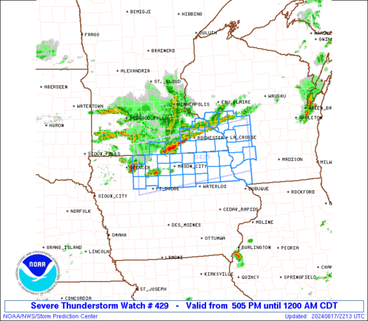
URGENT - IMMEDIATE BROADCAST REQUESTED
Tornado Watch Number 429
NWS Storm Prediction Center Norman OK
340 PM CDT Tue Jun 17 2025

The NWS Storm Prediction Center has issued a

* Tornado Watch for portions of
  Southern Kansas
  Northern Oklahoma
  Northeast Texas Panhandle

* Effective this Tuesday afternoon and evening from 340 PM until
  1000 PM CDT.

* Primary threats include...
  A couple tornadoes possible
  Scattered damaging winds and isolated significant gusts to 75
    mph likely
  Scattered large hail and isolated very large hail events to 3
    inches in diameter likely

SUMMARY...Thunderstorms are expected to rapidly develop this
afternoon along an axis from the northeast Texas Panhandle into
southeast Kansas.  Supercell thunderstorms are expected with a risk
of very large hail, damaging winds, and a few tornadoes.

The tornado watch area is approximately along and 70 statute miles
north and south of a line from 110 miles west southwest of Alva OK
to 10 miles southeast of Chanute KS. For a complete depiction of the
watch see the associated watch outline update (WOUS64 KWNS WOU9).

PRECAUTIONARY/PREPAREDNESS ACTIONS...

REMEMBER...A Tornado Watch means conditions are favorable for
tornadoes and severe thunderstorms in and close to the watch
area. Persons in these areas should be on the lookout for
threatening weather conditions and listen for later statements
and possible warnings.

&&

OTHER WATCH INFORMATION...CONTINUE...WW 428...

AVIATION...Tornadoes and a few severe thunderstorms with hail
surface and aloft to 3 inches. Extreme turbulence and surface wind
gusts to 65 knots. A few cumulonimbi with maximum tops to 500. Mean
storm motion vector 28030.

...Hart
Read morehttps://www.spc.noaa.gov/products/watch/ww0429.html
|
|


CMS The Best Conveyancing solicitors conveyancing quotes throughout the UK
For any webhosting enquiries please email webmaster@aus-city.com
|
|
Forums60
Topics793,270
Posts828,053
Members2,960
| |
Most Online102,106
Jul 10th, 2026
|
|
|


 - Click image for larger picture.")


