|
|
|
0 members (),
334
guests, and
23
robots. |
|
Key:
Admin,
Global Mod,
Mod
|
|
S |
M |
T |
W |
T |
F |
S |
|
|
|
1
|
2
|
3
|
4
|
5
|
|
6
|
7
|
8
|
9
|
10
|
11
|
12
|
|
13
|
14
|
15
|
16
|
17
|
18
|
19
|
|
20
|
21
|
22
|
23
|
24
|
25
|
26
|
|
27
|
28
|
29
|
30
|
31
|
|
|
|
There are no members with birthdays on this day. |

#766314
Fri 27 Jun 2025 07:48:PM
|
Joined: Feb 2001
Posts: 381,904
Launch Director
|
OP

Launch Director
Joined: Feb 2001
Posts: 381,904 |
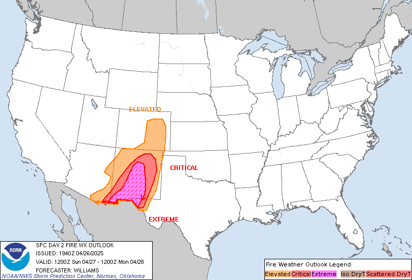
SPC Day 2 Fire Weather OutlookSPC Day 2 Fire Weather Outlook 
Day 2 Fire Weather Outlook
NWS Storm Prediction Center Norman OK
0247 PM CDT Fri Jun 27 2025

Valid 281200Z - 291200Z

...Southwest Wyoming...
A surface low in South Dakota, elevated mid-level flow and a
well-mixed boundary layer will promote sustained west winds of
around 15 mph across southwest Wyoming Saturday. These winds
combined with relative humidity of 15-20 percent amid dry fuels will
bring an elevated fire weather threat to much of the Wyoming Basin.

...Snake River Plain...
A passing mid-level trough and attendant wind maxima atop a dry and
well-mixed boundary layer will support elevated surface winds across
the central/eastern portions of the Snake River Plain. Westerly
winds of 15-20 mph and relative humidity in the 15-20 percent range
will support elevated fire weather conditions Saturday afternoon
where dry fuels exist.

..Williams.. 06/27/2025

.PREV DISCUSSION... /ISSUED 0136 AM CDT Fri Jun 27 2025/

...Synopsis...
Low-amplitude mid-level troughing over the Northern Rockies will
begin to shift eastward Saturday as high pressure over the southern
US continues to build. A belt of stronger mid-level flow will remain
in place over parts of the Intermountain West, supporting dry
downslope flow ahead of a weak cold front over the Northwest.

...ID into southwest WY...
Gusty surface winds through central ID and southwest WY could
support a few hours of elevated fire-weather potential Saturday. In
the wake of the departing upper trough, continued mid-level zonal
flow will linger over central ID. Confidence is highest that 15-20
mph surface winds will occur across portions of the central and
eastern Snake River Plain Saturday afternoon. Coincident with RH
below 20%, elevated fire-weather conditions are probable amid fuels
that continue to dry.

Farther east into WY, less confidence exists in sustained surface
winds greater than 15 mph occurring on a widespread basis through
the day. However, a very warm and dry air mass will remain in place.
This could support some localized fire-weather concerns, especially
where terrain-augmented winds may occasionally gust to 15-20 mph.

...Please see www.spc.noaa.gov/fire for graphic product...
Read morehttps://www.spc.noaa.gov/products/fire_wx/fwdy2.html
|
|


CMS The Best Conveyancing solicitors conveyancing quotes throughout the UK
For any webhosting enquiries please email webmaster@aus-city.com
|
|
Forums60
Topics730,006
Posts764,622
Members2,958
| |
Most Online4,158
Jun 21st, 2024
|
|
|
|
|
Copyright 1996 - 2024 by David Cottle. Designed by David Bate Jr. All Rights Reserved.
By using this forum, the user agrees not to transfer any data or technical information received under the agreement, to any other entity without the express approval of the AUS-CITY Forum Admins and/or authors of individual posts (Forum Admins and DoD/USSPACECOM for the analysis of satellite tracking data).
Two-line elements (TLE) and all other satellite data presented and distributed via this forum and e-mail lists of AUS-CITY are distributed with permission from DoD/USSTRATCOM.


Reprise Hosting


|

|