|
|
|
0 members (),
1,748
guests, and
19
robots. |
|
Key:
Admin,
Global Mod,
Mod
|
|
S |
M |
T |
W |
T |
F |
S |
|
|
|
|
1
|
2
|
3
|
4
|
|
5
|
6
|
7
|
8
|
9
|
10
|
11
|
|
12
|
13
|
14
|
15
|
16
|
17
|
18
|
|
19
|
20
|
21
|
22
|
23
|
24
|
25
|
|
26
|
27
|
28
|
29
|
30
|
31
|
|
|
There are no members with birthdays on this day. |

Significant magnitude 5.2 earthquake 58 km north of Valparaiso, Chile
• Small earthquake of magnitude 3.7 just reported 10 km southwest of Glogow, ...
• World Earthquake Report for Monday, 6 July 2026
• Significant 5.3 quake hits near Valparaiso, Provincia de Valparaíso, Regio...
• Moderate mag. 4.6 earthquake - South Pacific Ocean, 45 km north of Valparai...
• Strong mag. 5.2 earthquake - South Pacific Ocean, 58 km north of Valparaiso...
|

#770602
Wed 06 Aug 2025 04:50:PM
|
Joined: Feb 2001
Posts: 678,976
Launch Director
|
OP

Launch Director
Joined: Feb 2001
Posts: 678,976 |
Volcano earthquake report for Wednesday, 6 Aug 2025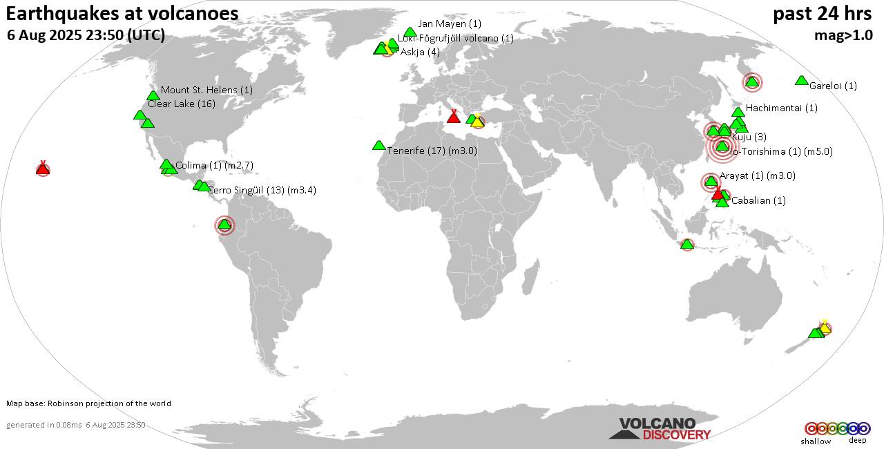 World map showing volcanoes with shallow (less than 50 km) earthquakes within 20 km radius during the past 24 hours on 6 Aug 2025 Number in brackets indicate nr of quakes. Quakes detected near: Abu (4 quakes between mag 0.5-1.0), Akuseki-jima (1 quake mag 2.5), Apaneca Range (3 quakes between mag 1.9-2.3), Arayat (1 quake mag 3.0), Askja (6 quakes between mag 0.5-1.5), Cabalian (1 quake mag 2.3)
Campi Flegrei (Phlegrean Fields) (5 quakes between mag 0.1-2.0), Canlaon (1 quake mag 2.1), Cerro Singüil (13 quakes between mag 1.9-3.4), Clear Lake (22 quakes between mag 0.2-1.5), Colima (1 quake mag 2.7), Coso (1 quake mag 1.9), Cuernos de Negros (1 quake mag 3.0), Daisen (3 quakes between mag 0.3-1.0), El Chichón (3 quakes between mag 2.5-2.9), Eldey (2 quakes between mag 1.1-1.3), Etna (1 quake mag 1.1), Grímsnes (3 quakes between mag 0.1-1.1), Hachimantai (1 quake mag 1.0), Halla (1 quake mag 3.0), Hiuchi (3 quakes between mag 0.3-1.0), Ibusuku (1 quake mag 1.1), Io-Torishima (1 quake mag 5.0), Isla El Tigre (3 quakes between mag 2.4-3.8), Jan Mayen (2 quakes between mag 1.1-1.2), Katla (3 quakes between mag 0.6-2.0), Kilauea (3 quakes between mag 1.8-2.6), Kolumbo (5 quakes between mag 1.3-1.8), Krísuvík (35 quakes between mag 0.0-1.8), Kuju (2 quakes between mag 0.1-1.3), Latukan (1 quake mag 2.4), Ljósufjöll (16 quakes between mag 0.0-1.8), Loki-Fögrufjöll volcano (2 quakes between mag 1.0-1.2), Methana (1 quake mag 1.4), Michoacán-Guanajuato (27 quakes between mag 2.0-3.4), Mount St. Helens (1 quake mag 1.4), Ngauruhoe (3 quakes between mag 0.6-1.5), Omanago (2 quakes between mag 0.3-2.3), Ontake-san (5 quakes between mag 0.2-1.1), Poas (1 quake mag 1.9), Santorini (6 quakes between mag 0.7-2.1), Spurr (3 quakes between mag 0.4-1.1), Sundoro (1 quake mag 2.2), Tenerife (4 quakes between mag 0.5-3.0), Tjörnes Fracture Zone (2 quakes between mag 0.6-2.1), To-shima (4 quakes between mag 1.1-1.9) (updated 16h50)
Note: Earthquakes within 20 km from and at depths less than 50 km under active volcanoes are reported. The list is not complete because many volcanoes are not monitored and/or seismic data in high resolution is not available publicly.
Volcanoes with recent earthquakes above magnitude 2 or more than 10 quakes are listed below:
Akuseki-jima volcano (Ryukyu Islands): magnitude 2.5 earthquakeA magnitude 2.5 earthquake occurred at the volcano 18 hours ago. The quake, which might be volcanic in origin, was located at a depth of 11.00 km depth at 12 km distance WSW from the volcano. Earthquake details: 2.5 quake East China Sea, Kagoshima-ken, 33 km southwest of Suwanose-jima Island, Japan, Aug 6, 2025 08:10 am (GMT +9) (12 km WSW) All earthquakes at Akuseki-jimaApaneca Range volcano (El Salvador): 3 earthquakes up to magnitude 2.33 earthquakes occurred near (under) the volcano during 10 hours, the last being recorded quake 3 hours ago. Hypocenter depths ranged between 7.00 and 3.00 km. Earthquake details: 2.3 quake 10.6 km northeast of Ahuachapan, Departamento de Ahuachapan, El Salvador, Aug 6, 2025 01:11 am (GMT -6) (12 km N) 2.2 quake 14 km north of Ahuachapan, Departamento de Ahuachapan, El Salvador, Aug 6, 2025 08:08 am (GMT -6) (17 km NNW) 1.9 quake 4.4 km north of Ahuachapan, Departamento de Ahuachapan, El Salvador, Aug 5, 2025 09:51 pm (GMT -6) (10 km NW) All earthquakes at Apaneca RangeArayat volcano (Luzon Island): magnitude 3.0 earthquakeA magnitude 3.0 earthquake occurred at the volcano 10 hours ago. The quake, which might be volcanic in origin, was located at a depth of 10.00 km depth at 19 km distance WSW from the volcano. Earthquake details: Reported seismic-like event (likely no quake): 1.2 km west of Angeles City, Province of Pampanga, Central Luzon, Philippines, Aug 6, 2025 02:37 pm (GMT +8) (19 km WSW) All earthquakes at ArayatCabalian volcano (Central Philippines): magnitude 2.3 earthquakeA magnitude 2.3 earthquake occurred at the volcano 4 hours ago. The quake, which might be volcanic in origin, was located at a depth of 4.00 km depth at 8 km distance NW from the volcano. Earthquake details: 2.3 quake 43 km northeast of Maasin, Philippines, Aug 6, 2025 08:57 pm (GMT +8) (8 km NW) All earthquakes at CabalianCanlaon volcano (Central Philippines): magnitude 2.1 earthquakeA magnitude 2.1 earthquake occurred at the volcano 3 hours ago. The quake, which might be volcanic in origin, was located at a depth of 12.00 km depth at 14 km distance S from the volcano. Earthquake details: 2.1 quake 41 km south of Mansilingan, Philippines, Aug 6, 2025 10:14 pm (GMT +8) (14 km S) All earthquakes at CanlaonCerro Singüil volcano (El Salvador): 13 earthquakes up to magnitude 3.4Possible earthquake swarm: 13 earthquakes occurred near (under) the volcano during 18 hours, the last being recorded quake 4 hours ago. Hypocenter depths ranged between 11.00 and 4.00 km. Earthquake details: (only 5 largest) 3.4 quake 22 km southeast of Jutiapa, Departamento de Jutiapa, Guatemala, Aug 5, 2025 11:23 pm (Guatemala time) (19 km WNW) 3.3 quake 26 km south of Jutiapa, Departamento de Jutiapa, Guatemala, Aug 5, 2025 09:05 pm (Guatemala time) (18 km W) 3.2 quake 22 km southeast of Jutiapa, Departamento de Jutiapa, Guatemala, Aug 6, 2025 01:21 am (Guatemala time) (19 km WNW) 3.2 quake 26 km south of Jutiapa, Departamento de Jutiapa, Guatemala, Aug 5, 2025 08:43 pm (Guatemala time) (18 km W) 3.0 quake 27 km southeast of Jutiapa, Departamento de Jutiapa, Guatemala, Aug 5, 2025 08:00 pm (Guatemala time) (16 km W) All earthquakes at Cerro SingüilClear Lake volcano (California): 22 earthquakes up to magnitude 1.5Possible earthquake swarm: 22 earthquakes occurred near (under) the volcano during 23 hours, the last being recorded quake 22 minutes ago. Hypocenter depths ranged between 6.99 and 0.14 km. Earthquake details: (only 5 largest) 1.5 quake 27 mi north of Santa Rosa, Sonoma County, California, United States, Aug 5, 2025 11:58 am (GMT -7) (18 km SSW) 1.3 quake 27 mi north of Santa Rosa, Sonoma County, California, United States, Aug 5, 2025 10:45 am (GMT -7) (17 km S) 1.2 quake 27 mi north of Santa Rosa, Sonoma County, California, United States, Aug 5, 2025 01:30 pm (GMT -7) (18 km SSW) 1.2 quake 27 mi north of Santa Rosa, Sonoma County, California, United States, Aug 5, 2025 11:39 pm (GMT -7) (16 km S) 1.0 quake 27 mi north of Santa Rosa, Sonoma County, California, United States, Aug 6, 2025 04:28 pm (Universal Time) (17 km SSW) All earthquakes at Clear LakeColima volcano (Western & Central Mexico): magnitude 2.7 earthquakeA magnitude 2.7 earthquake occurred at the volcano 8 hours ago. The quake, which might be volcanic in origin, was located at a depth of 36.20 km depth at 13 km distance SSW from the volcano. Earthquake details: 2.7 quake 18 km north of Colima, Estado de Colima, Mexico, Aug 6, 2025 02:53 am (GMT -6) (13 km SSW) All earthquakes at ColimaCuernos de Negros volcano (Central Philippines): magnitude 3.0 earthquakeA magnitude 3.0 earthquake occurred at the volcano 16 hours ago. The quake, which might be volcanic in origin, was located at a depth of 7.00 km depth at 9 km distance N from the volcano. Earthquake details: 3.0 quake 14 km west of Dumaguete, Philippines, Aug 6, 2025 08:32 am (Manila time) (9 km N) All earthquakes at Cuernos de NegrosEl Chichón volcano (Southern Mexico): 3 earthquakes up to magnitude 2.93 earthquakes occurred near (under) the volcano during 1 hour 17 minutes, the last being recorded quake 21 hours ago. Hypocenter depths ranged between 3.90 and 2.00 km. Earthquake details: 2.9 quake Estado de Chiapas, 37 km southwest of Teapa, Estado de Tabasco, Mexico, Aug 5, 2025 12:43 pm (Merida time) (2 km WNW) 2.5 quake Estado de Chiapas, 39 km southwest of Teapa, Estado de Tabasco, Mexico, Aug 5, 2025 01:59 pm (GMT -6) (4 km W) 2.5 quake Estado de Chiapas, 33 km southwest of Teapa, Estado de Tabasco, Mexico, Aug 5, 2025 01:59 pm (GMT -6) (4 km E) All earthquakes at El ChichónHalla volcano (South Korea): magnitude 3.0 earthquakeA magnitude 3.0 earthquake occurred at the volcano 6 hours ago. The quake, which might be volcanic in origin, was located at a depth of 10.00 km depth at 14 km distance N from the volcano. Earthquake details: Reported seismic-like event (likely no quake): 1.5 km south of Jeju City, Jeju-do, South Korea, Aug 6, 2025 07:52 pm (GMT +9) (14 km N) All earthquakes at HallaIo-Torishima volcano (Ryukyu Islands): magnitude 5.0 earthquakeA magnitude 5.0 earthquake occurred at the volcano 16 hours ago. The quake, which might be volcanic in origin, was located at a depth of 10.00 km depth at 12 km distance NNW from the volcano. Earthquake details: 5.0 quake East China Sea, 72 km west of Amagi, Kagoshima-ken, Japan, Aug 6, 2025 09:56 am (GMT +9) (12 km NNW) All earthquakes at Io-TorishimaIsla El Tigre volcano (Honduras): 3 earthquakes up to magnitude 3.83 earthquakes occurred near (under) the volcano during 1 hour 10 minutes, the last being recorded quake 15 hours ago. Hypocenter depths ranged between 4.10 and 3.00 km. Earthquake details: 3.8 quake North Pacific Ocean, 54 km west of Ciudad Choluteca, Honduras, Aug 5, 2025 06:46 pm (Tegucigalpa time) (6 km WNW) 3.8 quake North Pacific Ocean, 56 km west of Ciudad Choluteca, Honduras, Aug 5, 2025 06:46 pm (Tegucigalpa time) (8 km WNW) 2.4 quake North Pacific Ocean, 31 km southwest of San Lorenzo, Honduras, Aug 5, 2025 07:56 pm (GMT -6) (5 km W) All earthquakes at Isla El TigreKilauea volcano (Hawai'i (Big Island)): 3 earthquakes up to magnitude 2.63 earthquakes occurred near (under) the volcano during 9 minutes, the last being recorded quake 5 hours ago. Hypocenter depths ranged between 1.54 and 0.00 km. Earthquake details: 2.6 quake 26 mi southwest of Hilo, Hawaii County, Hawaii, United States, Aug 6, 2025 01:17 am (GMT -10) (1 km SSE) 1.9 quake 26 mi southwest of Hilo, Hawaii County, Hawaii, United States, Aug 6, 2025 01:20 am (GMT -10) (1 km SSW) 1.8 quake 26 mi southwest of Hilo, Hawaii County, Hawaii, United States, Aug 6, 2025 01:11 am (GMT -10) (1 km SSE) All earthquakes at KilaueaKrísuvík volcano (Reykjanes Peninsula, Iceland): 35 earthquakes up to magnitude 1.8Possible earthquake swarm: 35 earthquakes occurred near (under) the volcano during 20 hours, the last being recorded quake 2 hours ago. Hypocenter depths ranged between 5.80 and 0.10 km. Earthquake details: (only 5 largest) 1.8 quake 2.5 km N of Krýsuvík Aug 6, 2025 03:31 am (Universal Time) (3 km SE) 1.6 quake 2.1 km E of Krýsuvík Aug 6, 2025 12:02 am (Universal Time) (6 km SE) 1.6 quake 6.4 km NE of Krýsuvík Aug 6, 2025 02:35 pm (Universal Time) (6 km E) 1.4 quake 6.5 km NE of Krýsuvík Aug 6, 2025 01:11 pm (Universal Time) (6 km E) 1.2 quake 6.4 km NE of Krýsuvík Aug 6, 2025 01:10 pm (Universal Time) (6 km E) All earthquakes at KrísuvíkLatukan volcano (Mindanao): magnitude 2.4 earthquakeA magnitude 2.4 earthquake occurred at the volcano 4 hours ago. The quake, which might be volcanic in origin, was located at a depth of 2.00 km depth at 10 km distance S from the volcano. Earthquake details: 2.4 quake 43 km northeast of Cotabato, Philippines, Aug 6, 2025 08:25 pm (GMT +8) (10 km S) All earthquakes at LatukanLjósufjöll volcano (Iceland): 16 earthquakes up to magnitude 1.8Possible earthquake swarm: 16 earthquakes occurred near (under) the volcano during 21 hours, the last being recorded quake 1 hour 26 minutes ago. Hypocenter depths ranged between 24.40 and 15.00 km. Earthquake details: (only 5 largest) 1.8 quake 26.9 km N of Borgarnes Aug 5, 2025 09:16 pm (Universal Time) (16 km ESE) 1.4 quake 21.7 km N of Borgarnes Aug 6, 2025 03:08 am (Universal Time) (18 km SE) 1.1 quake 26.4 km N of Borgarnes Aug 6, 2025 02:23 pm (Universal Time) (16 km ESE) 1.1 quake 26.5 km N of Borgarnes Aug 5, 2025 06:03 pm (Universal Time) (17 km ESE) 1.0 quake 26.1 km N of Borgarnes Aug 5, 2025 06:08 pm (Universal Time) (17 km ESE) All earthquakes at LjósufjöllMichoacán-Guanajuato volcano (Western & Central Mexico): 27 earthquakes up to magnitude 3.4Possible earthquake swarm: 27 earthquakes occurred near (under) the volcano during 16 hours, the last being recorded quake 7 hours ago. Hypocenter depths ranged between 26.90 and 14.50 km. Earthquake details: (only 5 largest) 3.4 quake 30 km west of Uruapan, Estado de Michoacan de Ocampo, Mexico, Aug 5, 2025 01:04 pm (Mexico City time) (12 km SW) 3.4 quake 32 km west of Uruapan, Estado de Michoacan de Ocampo, Mexico, Aug 5, 2025 05:09 pm (Mexico City time) (15 km SW) 3.3 quake 35 km west of Uruapan, Estado de Michoacan de Ocampo, Mexico, Aug 5, 2025 11:42 pm (Mexico City time) (17 km SW) 3.2 quake 31 km west of Uruapan, Estado de Michoacan de Ocampo, Mexico, Aug 6, 2025 12:41 am (Mexico City time) (15 km SW) 2.9 quake 32 km west of Uruapan, Estado de Michoacan de Ocampo, Mexico, Aug 5, 2025 12:03 pm (Mexico City time) (14 km SW) All earthquakes at Michoacán-GuanajuatoOmanago volcano (Honshu): 2 earthquakes up to magnitude 2.32 earthquakes occurred near (under) the volcano during 60 seconds, the last being recorded quake 20 hours ago. Hypocenter depths ranged between 8.10 and 7.00 km. Earthquake details: 2.3 quake 12 km northwest of Imaichi, Tochigi, Japan, Aug 6, 2025 05:53 am (GMT +9) (10 km ENE) 0.3 quake 36 km northwest of Utsunomiya, Tochigi, Japan, Aug 6, 2025 05:54 am (GMT +9) (10 km ENE) All earthquakes at OmanagoSantorini volcano (Greece): 6 earthquakes up to magnitude 2.16 earthquakes occurred near (under) the volcano during 2 hours, the last being recorded quake 4 hours ago. Hypocenter depths ranged between 48.08 and 5.00 km. Earthquake details: (only 5 largest) 2.1 quake Aegean Sea, 3.3 km west of Santorini Island, Greece, Aug 6, 2025 01:19 pm (GMT +3) (2 km ENE) 1.9 quake 1.2 km southwest of Emporeio, Nomos Kykladon, South Aegean, Greece, Aug 6, 2025 03:25 pm (GMT +3) (7 km SSE) 1.9 quake 0.8 km south of Fira, Nomos Kykladon, South Aegean, Greece, Aug 6, 2025 01:20 pm (GMT +3) (3 km ENE) 1.8 quake Aegean Sea, 3.6 km west of Santorini Island, Greece, Aug 6, 2025 01:20 pm (GMT +3) (2 km NE) 1.4 quake Santorini Isl. - S. Greece Aug 6, 2025 01:21 pm (GMT +3) (3 km ENE) All earthquakes at SantoriniSundoro volcano (Central Java): magnitude 2.2 earthquakeA magnitude 2.2 earthquake occurred at the volcano 8 hours ago. The quake, which might be volcanic in origin, was located at a depth of 14.00 km depth at 5 km distance NNE from the volcano. Earthquake details: 2.2 quake Kabupaten Temanggung, 16 km northeast of Wonosobo, Indonesia, Aug 6, 2025 04:06 pm (GMT +7) (5 km NNE) All earthquakes at SundoroTenerife volcano (Canary Islands): 4 earthquakes up to magnitude 3.04 earthquakes occurred near (under) the volcano during 9 hours, the last being recorded quake 6 hours ago. Hypocenter depths ranged between 12.00 and 10.00 km. Earthquake details: Reported seismic-like event (likely no quake): 29 km west of Santa Cruz de Tenerife, Spain, Aug 6, 2025 12:07 pm (GMT +1) (19 km NNE) 1.2 quake 8.1 km southeast of La Orotava, Santa Cruz de Tenerife, Canary Islands, Spain, Aug 6, 2025 03:04 am (GMT +1) (17 km ENE) 1.1 quake 17 km north of Arona, Santa Cruz de Tenerife, Canary Islands, Spain, Aug 6, 2025 03:07 am (GMT +1) (4 km SW) 0.5 quake 16 km north of Arona, Santa Cruz de Tenerife, Canary Islands, Spain, Aug 6, 2025 02:06 am (Universal Time) (5 km SW) All earthquakes at TenerifeTjörnes Fracture Zone volcano (Iceland): 2 earthquakes up to magnitude 2.12 earthquakes occurred near (under) the volcano during 5 hours, the last being recorded quake 4 hours ago. Hypocenter depths ranged between 9.60 and 9.00 km. Earthquake details: 2.1 quake 14.7 km WSW of Kópasker Aug 6, 2025 12:46 pm (Universal Time) (17 km ESE) 0.6 quake 21.4 km W of Kópasker Aug 6, 2025 07:36 am (Universal Time) (8 km ENE) All earthquakes at Tjörnes Fracture ZoneUnnamed 52.92°N/158.52°E volcano (Southern Kamchatka): magnitude 4.5 earthquakeA magnitude 4.5 earthquake occurred at the volcano 18 hours ago. The quake, which might be volcanic in origin, was located at a depth of 40.40 km depth at 13 km distance SSE from the volcano. Earthquake details: 4.5 quake North Pacific Ocean, 145 km south of Petropavlovsk-Kamchatskiy, Kamchatka, Russia, Aug 6, 2025 11:10 am (Kamchatka time) (13 km SSE) All earthquakes at Unnamed 52.92°N/158.52°Ehttps://www.volcanodiscovery.com/earthquakes-volcanoes/news/277334/Volcano-earthquake-report-for-Wednesday-6-Aug-2025.html
|
|


CMS The Best Conveyancing solicitors conveyancing quotes throughout the UK
For any webhosting enquiries please email webmaster@aus-city.com
|
|
Forums60
Topics787,116
Posts821,890
Members2,960
| |
Most Online22,463
May 9th, 2026
|
|
|
|
|
Copyright 1996 - 2026 by David Cottle. Designed by David Bate Jr. All Rights Reserved.
By using this forum, the user agrees not to transfer any data or technical information received under this agreement to any other entity without the express approval of the AUS-CITY Forum Admins and/or authors of individual posts (Forum Admins and DoD/USSPACECOM for the analysis of satellite tracking data).
Two-line elements (TLE) and all other satellite data presented and distributed via this forum and AUS-CITY mailing lists are distributed with permission from DoD/USSTRATCOM.

|

|


 - Click image for larger picture.")


