|
0 members (),
621
guests, and
26
robots. |
|
Key:
Admin,
Global Mod,
Mod
|
|
S |
M |
T |
W |
T |
F |
S |
|
|
1
|
2
|
3
|
4
|
5
|
6
|
|
7
|
8
|
9
|
10
|
11
|
12
|
13
|
|
14
|
15
|
16
|
17
|
18
|
19
|
20
|
|
21
|
22
|
23
|
24
|
25
|
26
|
27
|
|
28
|
29
|
30
|
|
|
|
|
|
There are no members with birthdays on this day. |

Volcano earthquake report for Thursday, 11 Jun 2026
• Moderate mag. 4.6 earthquake - South Pacific Ocean, Bay of Plenty, 354 km n...
• Moderate magnitude 4.9 earthquake 92 km southwest of Bima, Indonesia
• Moderate mag. 4.4 earthquake - Indian Ocean, 84 km south of Dompu, Indonesi...
• Strong mag. 5.5 earthquake - Philippine Sea, 144 km north of Sangihe Besar ...
• World Earthquake Report for Wednesday, 10 June 2026
|

#774195
Tue 09 Sep 2025 10:00:PM
|
Joined: Feb 2001
Posts: 678,976
Launch Director
|
OP

Launch Director
Joined: Feb 2001
Posts: 678,976 |
SPC MD 2054MD 2054 CONCERNING SEVERE POTENTIAL...WATCH UNLIKELY FOR FAR EASTERN NM INTO PARTS OF THE TX PANHANDLE/SOUTH PLAINS 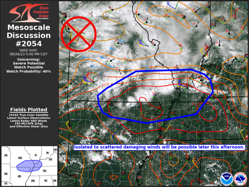
Mesoscale Discussion 2054
NWS Storm Prediction Center Norman OK
0337 PM CDT Tue Sep 09 2025

Areas affected...Far eastern NM into parts of the TX Panhandle/South
Plains

Concerning...Severe potential...Watch unlikely

Valid 092037Z - 092230Z

Probability of Watch Issuance...20 percent

SUMMARY...Strong to locally severe storms are possible late this
afternoon into the evening.

DISCUSSION...Storm initiation is underway across Roosevelt County,
NM as of 2030 UTC, with increasing cumulus noted farther north. In
addition to the ongoing development, continued strong heating and
weakening of MLCINH may eventually result in isolated storm
development farther east into parts of the TX Panhandle/South
Plains, near a weak surface confluence zone.

Initial high-based convection closer to the NM/TX border would pose
a threat of localized strong to severe gusts within the deeply mixed
environment. While deep-layer shear is relatively modest, isolated
hail cannot be ruled out given the presence of steep midlevel lapse
rates and MLCAPE of around 1000-1500 J/kg. Any storms that develop
or move farther east could pose a somewhat greater hail threat,
given the presence of richer low-level moisture and greater MLCAPE.

Coverage of the severe threat is expected to remain rather isolated,
rendering the need for a watch uncertain in this area. However,
within the northwesterly flow regime, only a slight increase in
deep-layer shear compared to what is currently observed/analyzed
could support potential for a supercell or two, and observational
trends will continue to be monitored regarding the need for watch
issuance.

..Dean/Hart.. 09/09/2025

...Please see www.spc.noaa.gov for graphic product...

ATTN...WFO...LUB...AMA...MAF...ABQ...

LAT...LON   33520354 34840359 36070326 36650315 36550252 35400149
            35170144 34100164 33460186 33320267 33520354

MOST PROBABLE PEAK WIND GUST...65-80 MPH
MOST PROBABLE PEAK HAIL SIZE...1.00-1.75 IN
Read morehttps://www.spc.noaa.gov/products/md/md2054.html
|
|


CMS The Best Conveyancing solicitors conveyancing quotes throughout the UK
For any webhosting enquiries please email webmaster@aus-city.com
|
|
Forums60
Topics780,487
Posts815,245
Members2,960
| |
Most Online22,463
May 9th, 2026
|
|
|


 - Click image for larger picture.")


