|
|
|
0 members (),
899
guests, and
28
robots. |
|
Key:
Admin,
Global Mod,
Mod
|
|
S |
M |
T |
W |
T |
F |
S |
|
|
|
|
1
|
2
|
3
|
4
|
|
5
|
6
|
7
|
8
|
9
|
10
|
11
|
|
12
|
13
|
14
|
15
|
16
|
17
|
18
|
|
19
|
20
|
21
|
22
|
23
|
24
|
25
|
|
26
|
27
|
28
|
29
|
30
|
31
|
|
|
There are no members with birthdays on this day. |
|
|
Joined: Feb 2001
Posts: 381,904
Launch Director
|
OP

Launch Director
Joined: Feb 2001
Posts: 381,904 |
Volcano earthquake report for Tuesday, 28 Oct 2025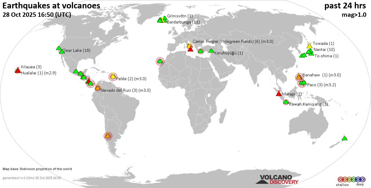 World map showing volcanoes with shallow (less than 50 km) earthquakes within 20 km radius during the past 24 hours on 28 Oct 2025 Number in brackets indicate nr of quakes. Quakes detected near: Akita-Komagatake (1 quake mag 1.0), Banahaw (1 quake mag 3.0), Bardarbunga (12 quakes between mag 0.0-1.8), Baru (1 quake mag 3.0), Brennisteinsfjöll (3 quakes between mag 0.6-2.3), Campi Flegrei (Phlegrean Fields) (7 quakes between mag 0.1-3.0)
Cerro Singüil (1 quake mag 2.1), Clear Lake (26 quakes between mag 0.2-2.0), Coso (7 quakes between mag 0.8-1.9), Cuilapa-Barbarena (1 quake mag 1.6), El Chichón (5 quakes between mag 1.9-2.8), Etna (2 quakes between mag 1.7-2.8), Gran Canaria (1 quake mag 3.0), Grímsvötn (2 quakes between mag 1.2-1.8), Hengill (1 quake mag 3.0), Hualalai (1 quake mag 2.9), Katla (12 quakes between mag 0.1-2.0), Kilauea (5 quakes between mag 1.3-2.1), Kolumbo (2 quakes between mag 2.2-2.2), Komaga-take (1 quake mag 1.2), Koruhüyüğü (1 quake mag 1.2), Kuju (1 quake mag 1.2), Laguna del Maule (1 quake mag 3.0), Ljósufjöll (11 quakes between mag 0.5-1.7), Marapi (1 quake mag 1.8), Nevado del Ruiz (2 quakes between mag 2.2-3.0), Ontake-san (2 quakes between mag 0.2-1.7), Paco (3 quakes between mag 2.1-3.2), Pelée (5 quakes between mag 0.7-3.0), Platanar (11 quakes between mag 1.5-3.4), Poas (1 quake mag 1.2), Reporoa (1 quake mag 1.9), San Pablo (5 quakes between mag 1.5-3.5), Taal (1 quake mag 3.0), Tenorio (2 quakes between mag 1.2-1.9), Tjörnes Fracture Zone (2 quakes between mag 0.4-1.0), To-shima (1 quake mag 1.3), Torfajökull (4 quakes between mag 0.7-1.1), Towada (1 quake mag 1.0), Yake-dake (5 quakes between mag 0.4-1.0), Öraefajökull (3 quakes between mag 0.1-1.1) (updated 10h50)
Note: Earthquakes within 20 km from and at depths less than 50 km under active volcanoes are reported. The list is not complete because many volcanoes are not monitored and/or seismic data in high resolution is not available publicly.
Volcanoes with recent earthquakes above magnitude 2 or more than 10 quakes are listed below:
Banahaw volcano (Luzon Island): magnitude 3.0 earthquakeA magnitude 3.0 earthquake occurred at the volcano 7 hours ago. The quake, which might be volcanic in origin, was located at a depth of 10.00 km depth at 8 km distance NW from the volcano. Earthquake details: Reported quake or seismic-like event: 31 km east of Calamba, Province of Laguna, Calabarzon, Philippines, Oct 28, 2025 12:01 pm (GMT +8) (8 km NW) All earthquakes at Banahaw Bardarbunga volcano (Iceland): 12 earthquakes up to magnitude 1.8Possible earthquake swarm: 12 earthquakes occurred near (under) the volcano during 20 hours, the last being recorded quake 3 hours ago. Hypocenter depths ranged between 7.60 and 0.10 km. Earthquake details: (only 5 largest) 1.8 quake 6.7 km E of Bárðarbunga Oct 27, 2025 06:28 pm (Universal Time) (7 km ENE) 1.7 quake 3.0 km SW of Bárðarbunga Oct 28, 2025 04:23 am (Universal Time) (2 km SW) 1.7 quake 4.6 km NE of Bárðarbunga Oct 27, 2025 12:28 pm (Universal Time) (6 km NE) 1.5 quake 3.1 km SSW of Bárðarbunga Oct 28, 2025 04:25 am (Universal Time) (2 km SW) 1.3 quake 5.3 km NE of Bárðarbunga Oct 28, 2025 05:05 am (Universal Time) (6 km NNE) All earthquakes at BardarbungaBaru volcano (Panama): magnitude 3.0 earthquakeA magnitude 3.0 earthquake occurred at the volcano 7 hours ago. The quake, which might be volcanic in origin, was located at a depth of 10.00 km depth at 11 km distance W from the volcano. Earthquake details: Reported seismic-like event (likely no quake): 1.5 km northwest of Volcan, Provincia de Chiriqui, Panama, Oct 27, 2025 10:28 pm (GMT -5) (11 km W) All earthquakes at BaruBrennisteinsfjöll volcano (Reykjanes Peninsula, Iceland): 3 earthquakes up to magnitude 2.33 earthquakes occurred near (under) the volcano during 10 hours, the last being recorded quake 12 hours ago. Hypocenter depths ranged between 7.80 and 2.30 km. Earthquake details: 2.3 quake 4.7 km WSW of Bláfjallaskáli Oct 27, 2025 11:07 pm (Reykjavik time) (7 km NE) 0.6 quake Iceland: 7.7 km ENE of Krýsuvík Oct 27, 2025 06:10 pm (Reykjavik time) (4 km WSW) 0.6 quake Iceland: 3.3 km NNW of Bláfjallaskáli Oct 27, 2025 01:08 pm (Reykjavik time) (13 km NE) All earthquakes at BrennisteinsfjöllCampi Flegrei (Phlegrean Fields) volcano (Italy): 7 earthquakes up to magnitude 3.07 earthquakes occurred near (under) the volcano during 19 hours, the last being recorded quake 5 hours ago. Hypocenter depths ranged between 10.00 and 1.00 km. Earthquake details: (only 5 largest) Reported seismic-like event (likely no quake): 1.8 km southwest of Naples, Napoli, Campania, Italy, Oct 27, 2025 10:26 pm (GMT +1) (9 km ENE) 2.0 quake Tyrrhenian Sea, 19 km northeast of Isola d'Ischia Island, Italy, Oct 28, 2025 05:13 am (Rome time) (4 km WSW) 0.9 quake 3.3 km east of Pozzuoli, Napoli, Campania, Italy, Oct 27, 2025 04:38 pm (GMT +1) (1 km NNW) 0.7 quake 3.6 km west of Fuorigrotta, Napoli, Campania, Italy, Oct 27, 2025 05:35 pm (GMT +1) (2 km ENE) 0.3 quake 3.9 km southwest of Pianura, Napoli, Campania, Italy, Oct 27, 2025 12:42 pm (GMT +1) (1 km NE) All earthquakes at Campi Flegrei (Phlegrean Fields)Cerro Singüil volcano (El Salvador): magnitude 2.1 earthquakeA magnitude 2.1 earthquake occurred at the volcano 23 hours ago. The quake, which might be volcanic in origin, was located at a depth of 4.00 km depth at 12 km distance WSW from the volcano. Earthquake details: 2.1 quake 14 km northeast of Ahuachapan, Departamento de Ahuachapan, El Salvador, Oct 27, 2025 05:59 am (El Salvador time) (12 km WSW) All earthquakes at Cerro SingüilClear Lake volcano (California): 26 earthquakes up to magnitude 2.0Possible earthquake swarm: 26 earthquakes occurred near (under) the volcano during 22 hours, the last being recorded quake 1 hour 32 minutes ago. Hypocenter depths ranged between 5.77 and 0.47 km. Earthquake details: (only 5 largest) 2.0 quake Sonoma County, 14 mi southwest of Clearlake, Lake County, California, United States, Oct 27, 2025 06:12 am (Los Angeles time) (15 km SSW) 1.4 quake Lake County, 28 mi north of Santa Rosa, Sonoma County, California, United States, Oct 27, 2025 08:27 am (Los Angeles time) (15 km S) 1.2 quake 28 mi north of Santa Rosa, Sonoma County, California, United States, Oct 27, 2025 08:08 pm (GMT -7) (16 km SSW) 1.2 quake 27 mi north of Santa Rosa, Sonoma County, California, United States, Oct 27, 2025 11:13 pm (GMT -7) (16 km S) 1.2 quake 3 km NNW of the Geysers, CA, Oct 27, 2025 09:46 pm (GMT -7) (19 km S) All earthquakes at Clear LakeEl Chichón volcano (Southern Mexico): 5 earthquakes up to magnitude 2.85 earthquakes occurred near (under) the volcano during 8 hours, the last being recorded quake 12 hours ago. Hypocenter depths ranged between 4.30 and 1.50 km. Earthquake details: 2.8 quake Estado de Chiapas, 36 km southwest of Teapa, Estado de Tabasco, Mexico, Oct 27, 2025 09:11 am (Merida time) (1 km SE) 2.5 quake Estado de Chiapas, 37 km southwest of Teapa, Estado de Tabasco, Mexico, Oct 27, 2025 01:23 pm (Merida time) (1 km W) 2.5 quake Estado de Chiapas, 35 km southwest of Teapa, Estado de Tabasco, Mexico, Oct 27, 2025 04:24 pm (Merida time) (2 km NNW) 2.1 quake Estado de Chiapas, 35 km southwest of Teapa, Estado de Tabasco, Mexico, Oct 27, 2025 04:58 pm (Merida time) (1 km N) 1.9 quake Estado de Chiapas, 37 km southwest of Teapa, Estado de Tabasco, Mexico, Oct 27, 2025 01:01 pm (Merida time) (1 km WNW) All earthquakes at El ChichónEtna volcano (Italy): 2 earthquakes up to magnitude 2.82 earthquakes occurred near (under) the volcano during 8 hours, the last being recorded quake 5 hours ago. Hypocenter depths ranged between 15.56 and 3.98 km. Earthquake details: 2.8 quake 21 km northwest of Catania, Catania, Sicily, Italy, Oct 27, 2025 11:39 pm (Rome time) (19 km SSW) 1.7 quake 15 km west of Giarre, Catania, Sicily, Italy, Oct 28, 2025 07:11 am (GMT +1) (2 km E) All earthquakes at EtnaGran Canaria volcano (Canary Islands): magnitude 3.0 earthquakeA magnitude 3.0 earthquake occurred at the volcano 13 hours ago. The quake, which might be volcanic in origin, was located at a depth of 10.00 km depth at 8 km distance SE from the volcano. Earthquake details: Reported seismic-like event (likely no quake): 18 km southwest of Las Palmas de Gran Canaria, Las Palmas, Canary Islands, Spain, Oct 27, 2025 09:45 pm (GMT +0) (8 km SE) All earthquakes at Gran CanariaHengill volcano (Iceland): magnitude 3.0 earthquakeA magnitude 3.0 earthquake occurred at the volcano 17 hours ago. The quake, which might be volcanic in origin, was located at a depth of 10.00 km depth at 19 km distance W from the volcano. Earthquake details: Reported seismic-like event (likely no quake): 8.8 km east of Reykjavik, Capital Region, Iceland, Oct 27, 2025 05:45 pm (GMT +0) (19 km W) All earthquakes at HengillHualalai volcano (Hawai'i (Big Island)): magnitude 2.9 earthquakeA magnitude 2.9 earthquake occurred at the volcano 2 hours ago. The quake, which might be volcanic in origin, was located at a depth of 29.09 km depth at 11 km distance WSW from the volcano. Earthquake details: 2.9 quake 2.2 mi northeast of Kailua-Kona, Hawaii County, Hawaii, United States, Oct 27, 2025 10:33 pm (Honolulu time) (11 km WSW) All earthquakes at HualalaiKatla volcano (Iceland): 12 earthquakes up to magnitude 2.0Possible earthquake swarm: 12 earthquakes occurred near (under) the volcano during 21 hours, the last being recorded quake 3 hours ago. Hypocenter depths ranged between 22.60 and 0.10 km. Earthquake details: (only 5 largest) 2.0 quake 6.4 km NNE of Hábunga Oct 27, 2025 12:37 pm (Reykjavik time) (1 km WNW) 1.1 quake 2.9 km WNW of Goðabunga Oct 27, 2025 11:18 am (Universal Time) (13 km W) 1.0 quake 2.4 km WNW of Goðabunga Oct 27, 2025 06:57 pm (Universal Time) (12 km W) 0.9 quake 3.4 km NE of Hábunga Oct 27, 2025 11:02 am (Universal Time) (4 km S) 0.8 quake 6.0 km ENE of Goðabunga Oct 28, 2025 03:29 am (Universal Time) (6 km NW) All earthquakes at KatlaKilauea volcano (Hawai'i (Big Island)): 5 earthquakes up to magnitude 2.15 earthquakes occurred near (under) the volcano during 12 hours, the last being recorded quake 6 hours ago. Hypocenter depths ranged between 28.84 and 0.37 km. Earthquake details: 2.1 quake 28 mi south of Hilo, Hawaii County, Hawaii, United States, Oct 27, 2025 06:19 am (Honolulu time) (14 km SE) 1.9 quake 20 mi south of Hilo, Hawaii County, Hawaii, United States, Oct 27, 2025 07:14 am (Honolulu time) (15 km ENE) 1.9 quake 36 mi southwest of Hilo, Hawaii County, Hawaii, United States, Oct 27, 2025 06:12 pm (Honolulu time) (18 km SW) 1.7 quake 12 km SSE of Volcano, Hawaii, Oct 27, 2025 06:48 pm (GMT -10) (13 km SE) 1.3 quake 13 km SSE of Volcano, Hawaii, Oct 27, 2025 06:19 am (GMT -10) (14 km SE) All earthquakes at KilaueaKolumbo volcano (Greece): 2 earthquakes up to magnitude 2.22 earthquakes occurred near (under) the volcano during 10 hours, the last being recorded quake 2 hours ago. Hypocenter depths ranged between 9.80 and 5.00 km. Earthquake details: 2.2 quake Aegean Sea, 29 km northeast of Oia, Nomos Kykladon, South Aegean, Greece, Oct 28, 2025 10:35 am (Athens time) (17 km NE) 2.2 quake Aegean Sea, 22 km northeast of Santorini Island, Greece, Oct 28, 2025 12:34 am (Athens time) (12 km ENE) All earthquakes at KolumboLaguna del Maule volcano (Central Chile and Argentina): magnitude 3.0 earthquakeA magnitude 3.0 earthquake occurred at the volcano 12 hours ago. The quake, which might be volcanic in origin, was located at a depth of 10.00 km depth at 6 km distance ESE from the volcano. Earthquake details: Reported seismic-like event (likely no quake): 104 km southeast of San Clemente, Talca, Region del Maule, Chile, Oct 27, 2025 07:56 pm (GMT -3) (6 km ESE) All earthquakes at Laguna del MauleLjósufjöll volcano (Iceland): 11 earthquakes up to magnitude 1.7Possible earthquake swarm: 11 earthquakes occurred near (under) the volcano during 14 hours, the last being recorded quake 8 hours ago. Hypocenter depths ranged between 18.90 and 4.50 km. Earthquake details: (only 5 largest) 1.7 quake Iceland: 27.8 km N of Borgarnes Oct 27, 2025 05:00 pm (Reykjavik time) (14 km ESE) 1.6 quake 30.0 km N of Borgarnes Oct 27, 2025 02:29 pm (Reykjavik time) (14 km ESE) 1.6 quake 29.9 km N of Borgarnes Oct 27, 2025 01:35 pm (Reykjavik time) (15 km ESE) 1.0 quake Iceland: 33.6 km N of Borgarnes Oct 28, 2025 03:09 am (Reykjavik time) (14 km E) 0.9 quake 28.5 km N of Borgarnes Oct 27, 2025 01:12 pm (Universal Time) (15 km ESE) All earthquakes at LjósufjöllNevado del Ruiz volcano (Colombia): 2 earthquakes up to magnitude 3.02 earthquakes occurred near (under) the volcano at nearly the same time (18:48 UTC). Hypocenter depths ranged between 6.00 and 1.00 km. Earthquake details: 3.0 quake Departamento de Tolima, 27 km southeast of Manizales, Colombia, Oct 27, 2025 01:48 pm (Bogota time) (3 km N) 2.2 quake Departamento de Tolima, 24 km southeast of Manizales, Colombia, Oct 27, 2025 01:48 pm (Bogota time) (5 km NNW) All earthquakes at Nevado del RuizPaco volcano (Mindanao): 3 earthquakes up to magnitude 3.23 earthquakes occurred near (under) the volcano during 10 hours, the last being recorded quake 5 hours ago. Hypocenter depths ranged between 43.00 and 16.00 km. Earthquake details: 3.2 quake 36 km south of Surigao, Province of Surigao del Norte, Caraga, Philippines, Oct 28, 2025 01:55 pm (Manila time) (14 km SSE) 2.2 quake Province of Agusan del Norte, 39 km south of Surigao, Philippines, Oct 28, 2025 02:09 pm (Manila time) (18 km SSE) 2.1 quake 33 km southeast of Surigao, Province of Surigao del Norte, Caraga, Philippines, Oct 28, 2025 03:50 am (Manila time) (16 km ESE) All earthquakes at PacoPelée volcano (Caribbean): 5 earthquakes up to magnitude 3.05 earthquakes occurred near (under) the volcano during 8 hours, the last being recorded quake 12 hours ago. Hypocenter depths ranged between 10.00 and 0.00 km. Earthquake details: Reported seismic-like event (likely no quake): 28 km northwest of Fort-de-France, Martinique, Oct 27, 2025 07:01 pm (GMT -4) (6 km WSW) 0.7 quake Martinique: Windward Islands Oct 27, 2025 11:20 am (GMT -4) (0 km NW) 0.7 quake Martinique: Windward Islands Oct 27, 2025 11:05 am (GMT -4) (1 km S) 0.7 quake 25 km northwest of Fort-de-France, Martinique, Oct 27, 2025 02:49 pm (GMT -4) (1 km SSE) 0.7 quake 25 km northwest of Fort-de-France, Martinique, Oct 27, 2025 12:25 pm (GMT -4) (1 km SSW) All earthquakes at PeléePlatanar volcano (Costa Rica): 11 earthquakes up to magnitude 3.4Possible earthquake swarm: 11 earthquakes occurred near (under) the volcano during 4 hours, the last being recorded quake 12 hours ago. Hypocenter depths ranged between 14.00 and 0.00 km. Earthquake details: (only 5 largest) 3.4 quake Provincia de Alajuela, 47 km northwest of San Jose, Costa Rica, Oct 27, 2025 03:00 pm (Costa Rica time) (5 km SSE) 2.6 quake 11 km southeast of Quesada, Provincia de Alajuela, Costa Rica, Oct 27, 2025 12:03 pm (Costa Rica time) (4 km SSE) 2.3 quake 10.5 km southeast of Quesada, Provincia de Alajuela, Costa Rica, Oct 27, 2025 03:22 pm (Costa Rica time) (3 km SE) 2.3 quake 13 km southeast of Quesada, Provincia de Alajuela, Costa Rica, Oct 27, 2025 12:05 pm (Costa Rica time) (6 km SSE) 2.2 quake Provincia de Alajuela, 44 km northwest of San Jose, Costa Rica, Oct 27, 2025 02:55 pm (Costa Rica time) (12 km S) All earthquakes at PlatanarSan Pablo volcano (Luzon Island): 5 earthquakes up to magnitude 3.55 earthquakes occurred near (under) the volcano during 1 hour 44 minutes, the last being recorded quake 6 hours ago. Hypocenter depths ranged between 33.00 and 5.00 km. Earthquake details: 3.5 quake 14 km southeast of Calamba, Province of Laguna, Calabarzon, Philippines, Oct 28, 2025 12:34 pm (Manila time) (8 km WSW) 3.2 quake 7.8 km south of Los Banos, Province of Laguna, Calabarzon, Philippines, Oct 28, 2025 12:34 pm (Manila time) (7 km WSW) 2.0 quake 11 km southeast of Calamba, Province of Laguna, Calabarzon, Philippines, Oct 28, 2025 11:31 am (Manila time) (9 km W) 1.8 quake 12 km southeast of Calamba, Province of Laguna, Calabarzon, Philippines, Oct 28, 2025 01:12 pm (GMT +8) (8 km W) 1.5 quake Philippines: 004 km S 50° W of Los Baños (Laguna) Oct 28, 2025 11:28 am (Manila time) (12 km WNW) All earthquakes at San PabloTaal volcano (Luzon Island): magnitude 3.0 earthquakeA magnitude 3.0 earthquake occurred at the volcano 9 hours ago. The quake, which might be volcanic in origin, was located at a depth of 10.00 km depth at 18 km distance ENE from the volcano. Earthquake details: Reported seismic-like event (likely no quake): 14 km south of Calamba, Province of Laguna, Calabarzon, Philippines, Oct 28, 2025 09:55 am (GMT +8) (18 km ENE) All earthquakes at TaalUnnamed 52.92°N/158.52°E volcano (Southern Kamchatka): magnitude 3.0 earthquakeA magnitude 3.0 earthquake occurred at the volcano 22 hours ago. The quake, which might be volcanic in origin, was located at a depth of 10.00 km depth at 1 km distance ESE from the volcano. Earthquake details: Reported seismic-like event (likely no quake): 18 km south of Petropavlovsk-Kamchatskiy, Kamchatka, Russia, Oct 28, 2025 12:40 am (GMT +12) (1 km ESE) All earthquakes at Unnamed 52.92°N/158.52°Ehttps://www.volcanodiscovery.com/earthquakes-volcanoes/news/285047/Volcano-earthquake-report-for-Tuesday-28-Oct-2025.html
|
|


CMS The Best Conveyancing solicitors conveyancing quotes throughout the UK
For any webhosting enquiries please email webmaster@aus-city.com
|
|
Forums60
Topics743,424
Posts778,063
Members2,958
| |
Most Online4,158
Jun 21st, 2024
|
|
|
|
|
Copyright 1996 - 2024 by David Cottle. Designed by David Bate Jr. All Rights Reserved.
By using this forum, the user agrees not to transfer any data or technical information received under the agreement, to any other entity without the express approval of the AUS-CITY Forum Admins and/or authors of individual posts (Forum Admins and DoD/USSPACECOM for the analysis of satellite tracking data).
Two-line elements (TLE) and all other satellite data presented and distributed via this forum and e-mail lists of AUS-CITY are distributed with permission from DoD/USSTRATCOM.

Reprise Hosting

|

|


 - Click image for larger picture.")


