|
|
|
0 members (),
785
guests, and
22
robots. |
|
Key:
Admin,
Global Mod,
Mod
|
|
S |
M |
T |
W |
T |
F |
S |
|
|
|
|
|
|
|
1
|
|
2
|
3
|
4
|
5
|
6
|
7
|
8
|
|
9
|
10
|
11
|
12
|
13
|
14
|
15
|
|
16
|
17
|
18
|
19
|
20
|
21
|
22
|
|
23
|
24
|
25
|
26
|
27
|
28
|
29
|
|
30
|
|
|
|
|
|
|
|
|
Joined: Feb 2001
Posts: 381,904
Launch Director
|
OP

Launch Director
Joined: Feb 2001
Posts: 381,904 |
Volcano earthquake report for Saturday, 1 Nov 2025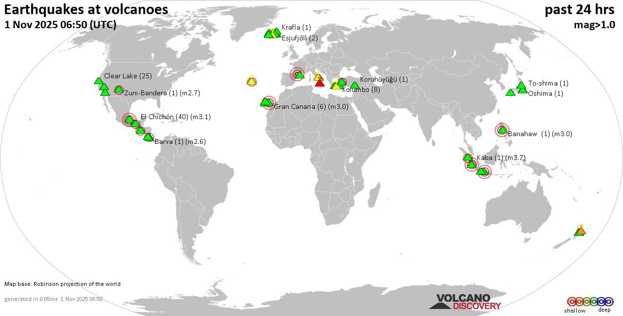 World map showing volcanoes with shallow (less than 50 km) earthquakes within 20 km radius during the past 24 hours on 1 Nov 2025 Number in brackets indicate nr of quakes. Quakes detected near: Apaneca Range (1 quake mag 2.0), Banahaw (1 quake mag 3.0), Campi Flegrei (Phlegrean Fields) (27 quakes between mag 0.1-1.6), Clear Lake (29 quakes between mag 0.4-2.1), Cofre de Perote (1 quake mag 3.4), Coso (3 quakes between mag 0.9-1.0)
El Chichón (30 quakes between mag 1.6-3.1), El Hierro (1 quake mag 1.5), Esjufjöll (2 quakes between mag 0.9-1.2), Etna (1 quake mag 1.3), Gran Canaria (6 quakes between mag 0.6-3.0), Hofsjökull (2 quakes between mag 1.9-2.5), Iriomote-jima (1 quake mag 1.0), Kaba (1 quake mag 3.7), Katla (4 quakes between mag 1.2-2.1), Kawah Karaha (1 quake mag 3.0), Kolumbo (8 quakes between mag 0.8-1.4), Krafla (3 quakes between mag 0.8-1.2), Krísuvík (12 quakes between mag 0.1-2.0), Kuju (63 quakes between mag 0.4-2.7), La Palma (1 quake mag 1.0), Ljósufjöll (2 quakes between mag 1.5-1.8), Loki-Fögrufjöll volcano (2 quakes between mag 1.6-1.7), Milos (1 quake mag 2.8), Nantai (5 quakes between mag 0.3-1.0), Nisyros (1 quake mag 3.4), Okataina (Tarawera) (1 quake mag 1.6), Olot Field (1 quake mag 3.0), Oshima (1 quake mag 1.4), Salton Buttes (3 quakes between mag 1.1-1.7), Santorini (2 quakes between mag 0.7-1.2), Sarik-Gajah (3 quakes between mag 2.2-3.3), Tenorio (1 quake mag 1.9), Terceira (2 quakes between mag 2.1-2.3), Whale Island (1 quake mag 2.7), Zuni-Bandera (1 quake mag 2.7) (updated 09h50)
Note: Earthquakes within 20 km from and at depths less than 50 km under active volcanoes are reported. The list is not complete because many volcanoes are not monitored and/or seismic data in high resolution is not available publicly.
Volcanoes with recent earthquakes above magnitude 2 or more than 10 quakes are listed below:
Banahaw volcano (Luzon Island): magnitude 3.0 earthquakeA magnitude 3.0 earthquake occurred at the volcano 23 hours ago. The quake, which might be volcanic in origin, was located at a depth of 10.00 km depth at 8 km distance WNW from the volcano. Earthquake details: Reported quake or seismic-like event: 33 km southwest of Quezon City, Philippines, Oct 31, 2025 07:16 pm (GMT +8) (8 km WNW) All earthquakes at Banahaw Campi Flegrei (Phlegrean Fields) volcano (Italy): 27 earthquakes up to magnitude 1.6Possible earthquake swarm: 27 earthquakes occurred near (under) the volcano during 20 hours, the last being recorded quake 1 hour 6 minutes ago. Hypocenter depths ranged between 5.25 and 0.02 km. Earthquake details: (only 5 largest) 1.6 quake 2.4 km southwest of Pozzuoli, Napoli, Campania, Italy, Oct 31, 2025 05:04 pm (Rome time) (5 km W) 1.2 quake 1.8 km southwest of Pozzuoli, Napoli, Campania, Italy, Oct 31, 2025 10:04 pm (Rome time) (5 km W) 1.1 quake 2.1 km west of Fuorigrotta, Napoli, Campania, Italy, Nov 1, 2025 06:09 am (GMT +1) (3 km E) 1.1 quake 1.8 km southwest of Pozzuoli, Napoli, Campania, Italy, Oct 31, 2025 07:23 pm (Rome time) (5 km W) 1.1 quake Tyrrhenian Sea, 20 km northeast of Isola d'Ischia Island, Italy, Oct 31, 2025 09:10 pm (Rome time) (2 km SW) All earthquakes at Campi Flegrei (Phlegrean Fields)Clear Lake volcano (California): 29 earthquakes up to magnitude 2.1Possible earthquake swarm: 29 earthquakes occurred near (under) the volcano during 23 hours, the last being recorded quake 1 hour 12 minutes ago. Hypocenter depths ranged between 4.30 and 0.88 km. Earthquake details: (only 5 largest) 2.1 quake 12 mi southwest of Clearlake, Lake County, California, United States, Oct 31, 2025 05:05 am (Los Angeles time) (16 km S) 1.9 quake Sonoma County, 14 mi southwest of Clearlake, Lake County, California, United States, Nov 1, 2025 01:27 am (GMT -7) (17 km SSW) 1.7 quake 13 mi southwest of Clearlake, Lake County, California, United States, Oct 31, 2025 10:58 am (GMT -7) (19 km S) 1.6 quake Sonoma County, 14 mi southwest of Clearlake, Lake County, California, United States, Nov 1, 2025 01:27 am (GMT -7) (17 km SSW) 1.2 quake Lake County, 25 mi north of Santa Rosa, Sonoma County, California, United States, Oct 31, 2025 12:06 pm (GMT -7) (19 km S) All earthquakes at Clear LakeCofre de Perote volcano (): magnitude 3.4 earthquakeA magnitude 3.4 earthquake occurred at the volcano 18 hours ago. The quake, which might be volcanic in origin, was located at a depth of 7.70 km depth at 9 km distance WNW from the volcano. Earthquake details: 3.4 quake 4.3 km southeast of Perote, Estado de Veracruz-Llave, Mexico, Oct 31, 2025 09:49 am (Mexico City time) (9 km WNW) All earthquakes at Cofre de PeroteEl Chichón volcano (Southern Mexico): 30 earthquakes up to magnitude 3.1Possible earthquake swarm: 30 earthquakes occurred near (under) the volcano during 12 hours, the last being recorded quake 11 hours ago. Hypocenter depths ranged between 4.60 and 1.90 km. Earthquake details: (only 5 largest) 3.1 quake Estado de Chiapas, 36 km southwest of Teapa, Estado de Tabasco, Mexico, Oct 31, 2025 07:53 am (Merida time) (1 km N) 3.0 quake Estado de Chiapas, 36 km southwest of Teapa, Estado de Tabasco, Mexico, Oct 31, 2025 04:38 am (Merida time) (1 km N) 3.0 quake Estado de Chiapas, 37 km southwest of Teapa, Estado de Tabasco, Mexico, Oct 31, 2025 02:39 pm (Merida time) (1 km WSW) 2.9 quake Estado de Chiapas, 37 km southwest of Teapa, Estado de Tabasco, Mexico, Oct 31, 2025 09:23 am (Merida time) (0 km WSW) 2.9 quake Estado de Chiapas, 37 km southwest of Teapa, Estado de Tabasco, Mexico, Oct 31, 2025 04:58 pm (Merida time) (2 km S) All earthquakes at El ChichónGran Canaria volcano (Canary Islands): 6 earthquakes up to magnitude 3.06 earthquakes occurred near (under) the volcano during 13 hours, the last being recorded quake 11 hours ago. Hypocenter depths ranged between 10.00 and 1.00 km. Earthquake details: (only 5 largest) Reported seismic-like event (likely no quake): 27 km west of Las Palmas de Gran Canaria, Las Palmas, Canary Islands, Spain, Oct 31, 2025 09:53 pm (GMT +0) (10 km NW) 0.9 quake 26 km west of Las Palmas de Gran Canaria, Las Palmas, Canary Islands, Spain, Oct 31, 2025 12:39 pm (Universal Time) (7 km WNW) 0.8 quake 25 km west of Las Palmas de Gran Canaria, Las Palmas, Canary Islands, Spain, Oct 31, 2025 11:30 am (Universal Time) (6 km NW) 0.8 quake 26 km west of Las Palmas de Gran Canaria, Las Palmas, Canary Islands, Spain, Oct 31, 2025 10:21 am (Universal Time) (7 km WNW) 0.7 quake 26 km west of Las Palmas de Gran Canaria, Las Palmas, Canary Islands, Spain, Oct 31, 2025 12:42 pm (Universal Time) (7 km WNW) All earthquakes at Gran CanariaHofsjökull volcano (Iceland): 2 earthquakes up to magnitude 2.52 earthquakes occurred near (under) the volcano during 79 seconds, the last being recorded quake 21 hours ago. Hypocenter depths ranged between 3.20 and 2.60 km. Earthquake details: 2.5 quake 31.0 km E of Hveravellir Oct 31, 2025 12:43 pm (Reykjavik time) (10 km N) 1.9 quake 31.0 km WSW of Laugafell Oct 31, 2025 12:42 pm (Reykjavik time) (11 km N) All earthquakes at HofsjökullKaba volcano (Sumatra): magnitude 3.7 earthquakeA magnitude 3.7 earthquake occurred at the volcano 4 hours ago. The quake, which might be volcanic in origin, was located at a depth of 10.00 km depth at 18 km distance WNW from the volcano. Earthquake details: 3.7 quake 5.8 km west of Curup, Kabupaten Rejang Lebong, Bengkulu, Indonesia, Nov 1, 2025 12:26 pm (Jakarta time) (18 km WNW) All earthquakes at KabaKatla volcano (Iceland): 4 earthquakes up to magnitude 2.14 earthquakes occurred near (under) the volcano during 18 hours, the last being recorded quake 19 minutes ago. Hypocenter depths ranged between 3.70 and 0.10 km. Earthquake details: 2.1 quake 6.9 km NNE of Hábunga Oct 31, 2025 03:39 pm (Reykjavik time) (1 km N) 2.0 quake 1.5 km SW of Goðabunga Nov 1, 2025 09:03 am (Universal Time) (10 km W) 1.5 quake Iceland: 8.9 km NE of Goðabunga Oct 31, 2025 10:42 pm (Reykjavik time) (9 km NNW) 1.2 quake Iceland: 2.9 km NE of Hábunga Nov 1, 2025 09:30 am (Reykjavik time) (4 km S) All earthquakes at KatlaKawah Karaha volcano (West Java): magnitude 3.0 earthquakeA magnitude 3.0 earthquake occurred at the volcano 4 hours ago. The quake, which might be volcanic in origin, was located at a depth of 10.00 km depth at 12 km distance E from the volcano. Earthquake details: Reported seismic-like event (likely no quake): 23 km north of Tasikmalaya, Kota Tasikmalaya, Jawa Barat, Indonesia, Nov 1, 2025 12:27 pm (GMT +7) (12 km E) All earthquakes at Kawah KarahaKrísuvík volcano (Reykjanes Peninsula, Iceland): 12 earthquakes up to magnitude 2.0Possible earthquake swarm: 12 earthquakes occurred near (under) the volcano during 18 hours, the last being recorded quake 3 hours ago. Hypocenter depths ranged between 6.60 and 0.10 km. Earthquake details: (only 5 largest) 2.0 quake 3.9 km ESE of Keilir Oct 31, 2025 12:48 pm (Reykjavik time) (0 km SE) 1.6 quake 6.2 km NE of Krýsuvík Oct 31, 2025 10:33 pm (Universal Time) (6 km E) 1.5 quake 6.1 km NE of Krýsuvík Oct 31, 2025 10:19 pm (Universal Time) (5 km E) 1.1 quake 5.6 km NE of Krýsuvík Oct 31, 2025 10:38 pm (Universal Time) (5 km E) 1.1 quake Iceland: 6.0 km NE of Krýsuvík Oct 31, 2025 11:06 pm (Reykjavik time) (6 km E) All earthquakes at KrísuvíkKuju volcano (Kyushu): 63 earthquakes up to magnitude 2.7Possible earthquake swarm: 63 earthquakes occurred near (under) the volcano during 6 hours, the last being recorded quake 1 hour 22 minutes ago. Hypocenter depths ranged between 15.90 and 6.10 km. Earthquake details: (only 5 largest) 2.7 quake 45 km west of Oita, Oita Prefecture, Japan, Nov 1, 2025 11:17 am (GMT +9) (5 km W) 2.6 quake 41 km west of Oita, Oita Prefecture, Japan, Nov 1, 2025 04:48 pm (GMT +9) (8 km NW) 2.5 quake 41 km west of Oita, Oita Prefecture, Japan, Nov 1, 2025 04:48 pm (GMT +9) (7 km WNW) 2.3 quake 41 km west of Oita, Oita Prefecture, Japan, Nov 1, 2025 11:45 am (GMT +9) (7 km WNW) 2.2 quake 41 km west of Oita, Oita Prefecture, Japan, Nov 1, 2025 11:36 am (GMT +9) (7 km WNW) All earthquakes at KujuMilos volcano (Greece): magnitude 2.8 earthquakeA magnitude 2.8 earthquake occurred at the volcano 12 hours ago. The quake, which might be volcanic in origin, was located at a depth of 10.00 km depth at 12 km distance NW from the volcano. Earthquake details: 2.8 quake 7.4 km west of Adamantas, Nomos Kykladon, South Aegean, Greece, Oct 31, 2025 11:33 pm (Athens time) (12 km NW) All earthquakes at MilosNisyros volcano (Greece): magnitude 3.4 earthquakeA magnitude 3.4 earthquake occurred at the volcano 22 hours ago. The quake, which might be volcanic in origin, was located at a depth of 17.20 km depth at 10 km distance S from the volcano. Earthquake details: 3.4 quake Aegean Sea, 12 km south of Nisi Nisyros Island, Dodecanese, South Aegean, Greece, Oct 31, 2025 01:38 pm (Athens time) (10 km S) All earthquakes at NisyrosOlot Field volcano (Spain): magnitude 3.0 earthquakeA magnitude 3.0 earthquake occurred at the volcano 24 hours ago. The quake, which might be volcanic in origin, was located at a depth of 10.00 km depth at 0 km distance WNW from the volcano. Earthquake details: Reported quake or seismic-like event: 22 km south of Saint-Gaudens, Upper Garonne, Occitanie, France, Oct 31, 2025 11:03 am (GMT +1) (0 km WNW) All earthquakes at Olot FieldSarik-Gajah volcano (Sumatra): 3 earthquakes up to magnitude 3.33 earthquakes occurred near (under) the volcano during 42 minutes, the last being recorded quake 8 hours ago. Hypocenter depths ranged between 10.00 and 10.00 km. Earthquake details: 3.3 quake Kabupaten Pasaman, 33 km northwest of Bukittinggi, Indonesia, Nov 1, 2025 08:28 am (Jakarta time) (17 km S) 2.3 quake Kabupaten Pasaman, 38 km northwest of Bukittinggi, Indonesia, Nov 1, 2025 09:10 am (Jakarta time) (11 km S) 2.2 quake Kabupaten Pasaman, 37 km northwest of Bukittinggi, Indonesia, Nov 1, 2025 08:57 am (Jakarta time) (13 km S) All earthquakes at Sarik-GajahTerceira volcano (Azores): 2 earthquakes up to magnitude 2.32 earthquakes occurred near (under) the volcano during 12 hours, the last being recorded quake 10 hours ago. Hypocenter depths ranged between 4.40 and 1.10 km. Earthquake details: 2.3 quake 15 km northwest of Angra do Heroismo, Azores, Portugal, Oct 31, 2025 10:30 am (GMT -1) (3 km N) 2.1 quake 13 km northwest of Angra do Heroismo, Azores, Portugal, Oct 31, 2025 10:56 pm (Azores time) (2 km NE) All earthquakes at TerceiraWhale Island volcano (New Zealand): magnitude 2.7 earthquakeA magnitude 2.7 earthquake occurred at the volcano 1 hour 55 minutes ago. The quake, which might be volcanic in origin, was located at a depth of 5.00 km depth at 6 km distance ENE from the volcano. Earthquake details: 2.7 quake South Pacific Ocean, 15 km north of Whakatane, Bay of Plenty, New Zealand, Nov 1, 2025 08:54 pm (Auckland time) (6 km ENE) All earthquakes at Whale IslandZuni-Bandera volcano (New Mexico): magnitude 2.7 earthquakeA magnitude 2.7 earthquake occurred at the volcano 21 hours ago. The quake, which might be volcanic in origin, was located at a depth of 4.90 km depth at 12 km distance SSW from the volcano. Earthquake details: 2.7 quake 33 mi south of Grants, Cibola County, New Mexico, United States, Oct 31, 2025 05:42 am (Denver time) (12 km SSW) All earthquakes at Zuni-Banderahttps://www.volcanodiscovery.com/earthquakes-volcanoes/news/285719/Volcano-earthquake-report-for-Saturday-1-Nov-2025.html
|
|


CMS The Best Conveyancing solicitors conveyancing quotes throughout the UK
For any webhosting enquiries please email webmaster@aus-city.com
|
|
Forums60
Topics744,806
Posts779,455
Members2,958
| |
Most Online4,158
Jun 21st, 2024
|
|
|
|
|
Copyright 1996 - 2024 by David Cottle. Designed by David Bate Jr. All Rights Reserved.
By using this forum, the user agrees not to transfer any data or technical information received under the agreement, to any other entity without the express approval of the AUS-CITY Forum Admins and/or authors of individual posts (Forum Admins and DoD/USSPACECOM for the analysis of satellite tracking data).
Two-line elements (TLE) and all other satellite data presented and distributed via this forum and e-mail lists of AUS-CITY are distributed with permission from DoD/USSTRATCOM.

Reprise Hosting

|

|


 - Click image for larger picture.")


