|
|
|
0 members (),
2,049
guests, and
26
robots. |
|
Key:
Admin,
Global Mod,
Mod
|
|
S |
M |
T |
W |
T |
F |
S |
|
|
|
|
1
|
2
|
3
|
4
|
|
5
|
6
|
7
|
8
|
9
|
10
|
11
|
|
12
|
13
|
14
|
15
|
16
|
17
|
18
|
|
19
|
20
|
21
|
22
|
23
|
24
|
25
|
|
26
|
27
|
28
|
29
|
30
|
31
|
|
|
There are no members with birthdays on this day. |
|
|
|
|
|
|
|
|
|
|
|
|
|
|
|
|
|
|
by Webmaster - Tue 14 Jul 2026 08:31:AM
|
by Webmaster - Tue 14 Jul 2026 08:31:AM
|
by Webmaster - Tue 14 Jul 2026 08:31:AM
|

Volcano earthquake report for Friday, 10 Jul 2026
• Moderate mag. 4.2 earthquake - 133 km northwest of Ternate, Kota Ternate, N...
• World Earthquake Report for Friday, 10 July 2026
• Moderate mag. 4.6 earthquake - 17 km southwest of Comalapa, Estado de Chiap...
• Moderate mag. 4.1 earthquake - Olyutorskiy Rayon, 47 km northwest of Tilich...
• Moderate mag. 4.0 earthquake - Hawke's Bay, New Zealand, on Saturday, Jul 1...
|

#781539
Sun 02 Nov 2025 03:50:AM
|
Joined: Feb 2001
Posts: 678,976
Launch Director
|
OP

Launch Director
Joined: Feb 2001
Posts: 678,976 |
Volcano earthquake report for Sunday, 2 Nov 2025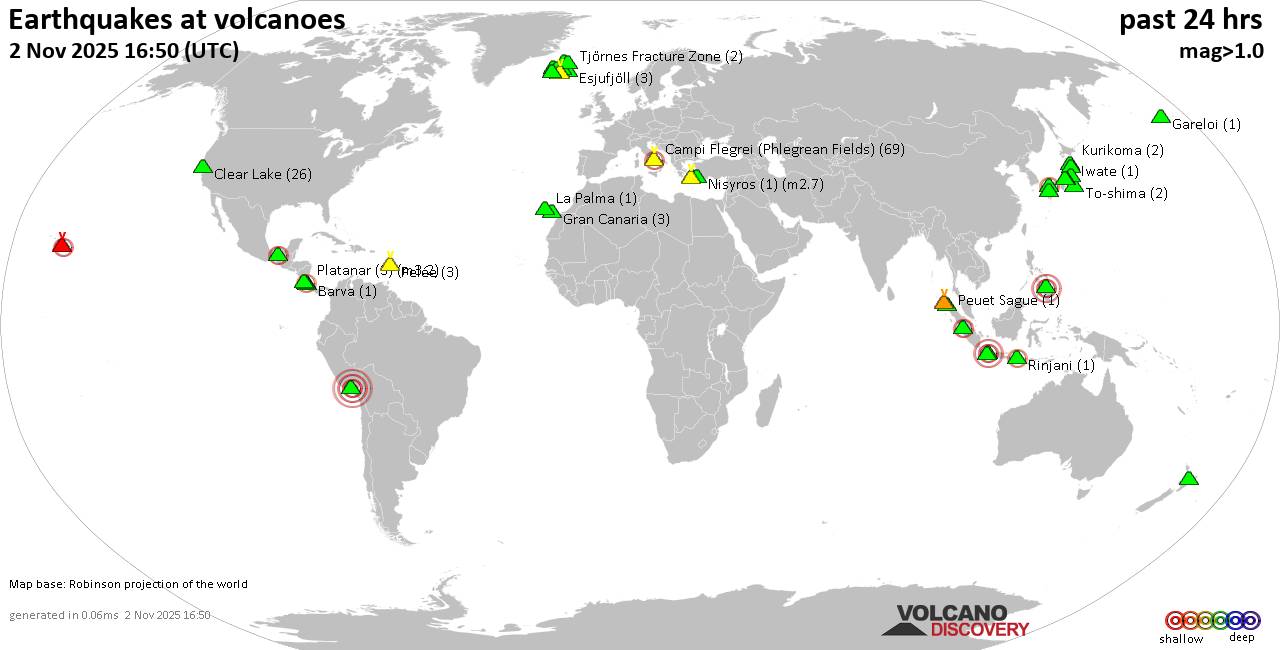 World map showing volcanoes with shallow (less than 50 km) earthquakes within 20 km radius during the past 24 hours on 2 Nov 2025 Number in brackets indicate nr of quakes. Quakes detected near: Campi Flegrei (Phlegrean Fields) (39 quakes between mag 0.1-2.1), Clear Lake (38 quakes between mag 0.2-2.3), El Chichón (28 quakes between mag 1.2-3.0), El Hierro (1 quake mag 1.5), Esjufjöll (3 quakes between mag 0.8-1.6), Etna (1 quake mag 1.4)
Gran Canaria (1 quake mag 1.1), Hibok-Hibok (1 quake mag 3.0), Huambo (1 quake mag 3.5), Iriomote-jima (1 quake mag 1.0), Katla (5 quakes between mag 0.5-2.0), Kawah Kamojang (1 quake mag 2.4), Kawah Karaha (2 quakes between mag 3.0-3.0), Kolumbo (3 quakes between mag 0.9-1.4), Krafla (1 quake mag 1.0), Krísuvík (9 quakes between mag 0.6-1.9), Kuju (74 quakes between mag 0.1-2.6), La Palma (1 quake mag 1.6), Ljósufjöll (2 quakes between mag 1.8-2.0), Loki-Fögrufjöll volcano (1 quake mag 1.6), Methana (1 quake mag 1.6), Nantai (8 quakes between mag 0.1-1.4), Nikko-Shirane (7 quakes between mag 0.4-1.5), Nisyros (3 quakes between mag 2.4-3.4), Ontake-san (4 quakes between mag 0.1-1.2), Osore-yama (3 quakes between mag 0.5-1.2), Papandayan (2 quakes between mag 2.0-3.0), Pelée (1 quake mag 1.0), Peuet Sague (1 quake mag 1.7), Reporoa (5 quakes between mag 1.2-2.0), Seulawah Agam (1 quake mag 1.9), Terceira (1 quake mag 2.0), Tjörnes Fracture Zone (2 quakes between mag 1.3-1.6), To-shima (1 quake mag 1.2), Whale Island (1 quake mag 2.7), Yake-dake (4 quakes between mag 0.3-1.6) (updated 03h50)
Note: Earthquakes within 20 km from and at depths less than 50 km under active volcanoes are reported. The list is not complete because many volcanoes are not monitored and/or seismic data in high resolution is not available publicly.
Volcanoes with recent earthquakes above magnitude 2 or more than 10 quakes are listed below:
Campi Flegrei (Phlegrean Fields) volcano (Italy): 39 earthquakes up to magnitude 2.1Possible earthquake swarm: 39 earthquakes occurred near (under) the volcano during 22 hours, the last being recorded quake 53 minutes ago. Hypocenter depths ranged between 5.28 and 0.00 km. Earthquake details: (only 5 largest) 2.1 quake 1.4 km southeast of Pozzuoli, Napoli, Campania, Italy, Nov 2, 2025 03:40 am (GMT +1) (3 km WNW) 1.8 quake 3.4 km southeast of Pozzuoli, Napoli, Campania, Italy, Nov 2, 2025 02:43 am (GMT +1) (1 km NW) 1.8 quake 2.7 km southeast of Pozzuoli, Napoli, Campania, Italy, Nov 2, 2025 03:32 am (GMT +1) (2 km W) 1.5 quake Tyrrhenian Sea, 21 km northeast of Isola d'Ischia Island, Italy, Nov 1, 2025 10:04 pm (GMT +1) (2 km S) 1.4 quake Tyrrhenian Sea, 21 km northeast of Isola d'Ischia Island, Italy, Nov 1, 2025 10:02 pm (GMT +1) (2 km S) All earthquakes at Campi Flegrei (Phlegrean Fields)Clear Lake volcano (California): 38 earthquakes up to magnitude 2.3Possible earthquake swarm: 38 earthquakes occurred near (under) the volcano during 23 hours, the last being recorded quake 39 minutes ago. Hypocenter depths ranged between 10.79 and 0.88 km. Earthquake details: (only 5 largest) 2.3 quake Sonoma County, 14 mi southwest of Clearlake, Lake County, California, United States, Nov 1, 2025 07:37 pm (Los Angeles time) (16 km SSW) 1.9 quake Sonoma County, 14 mi southwest of Clearlake, Lake County, California, United States, Nov 1, 2025 01:27 am (GMT -7) (17 km SSW) 1.6 quake Sonoma County, 14 mi southwest of Clearlake, Lake County, California, United States, Nov 1, 2025 01:27 am (GMT -7) (17 km SSW) 1.3 quake 27 mi north of Santa Rosa, Sonoma County, California, United States, Nov 1, 2025 11:18 am (GMT -7) (18 km SSW) 1.2 quake 27 mi north of Santa Rosa, Sonoma County, California, United States, Nov 1, 2025 08:10 pm (GMT -7) (16 km SSW) All earthquakes at Clear LakeEl Chichón volcano (Southern Mexico): 28 earthquakes up to magnitude 3.0Possible earthquake swarm: 28 earthquakes occurred near (under) the volcano during 18 hours, the last being recorded quake 5 hours ago. Hypocenter depths ranged between 4.50 and 1.50 km. Earthquake details: (only 5 largest) 3.0 quake Estado de Chiapas, 37 km southwest of Teapa, Estado de Tabasco, Mexico, Nov 1, 2025 04:45 am (Merida time) (1 km WSW) 3.0 quake Estado de Chiapas, 37 km southwest of Teapa, Estado de Tabasco, Mexico, Nov 1, 2025 01:27 pm (Merida time) (1 km SSW) 2.7 quake Estado de Chiapas, 35 km southwest of Teapa, Estado de Tabasco, Mexico, Nov 1, 2025 04:51 pm (Merida time) (2 km E) 2.4 quake Estado de Chiapas, 35 km southwest of Teapa, Estado de Tabasco, Mexico, Nov 1, 2025 11:24 am (Merida time) (2 km E) 2.4 quake Estado de Chiapas, 37 km southwest of Teapa, Estado de Tabasco, Mexico, Nov 1, 2025 03:51 am (Merida time) (1 km SW) All earthquakes at El ChichónHibok-Hibok volcano (Mindanao): magnitude 3.0 earthquakeA magnitude 3.0 earthquake occurred at the volcano 5 hours ago. The quake, which might be volcanic in origin, was located at a depth of 10.00 km depth at 7 km distance SSE from the volcano. Earthquake details: Reported seismic-like event (likely no quake): 11 km south of Mambajao, Province of Camiguin, Northern Mindanao, Philippines, Nov 2, 2025 07:11 am (GMT +8) (7 km SSE) All earthquakes at Hibok-HibokHuambo volcano (Peru): magnitude 3.5 earthquakeA magnitude 3.5 earthquake occurred at the volcano 5 hours ago. The quake, which might be volcanic in origin, was located at a depth of 14.00 km depth at 11 km distance NNE from the volcano. Earthquake details: 3.5 quake 94 km northwest of Arequipa, Arequipa, Peru, Nov 1, 2025 05:52 pm (Lima time) (11 km NNE) All earthquakes at HuamboKawah Kamojang volcano (West Java): magnitude 2.4 earthquakeA magnitude 2.4 earthquake occurred at the volcano 11 hours ago. The quake, which might be volcanic in origin, was located at a depth of 10.00 km depth at 17 km distance WSW from the volcano. Earthquake details: 2.4 quake 15 km southeast of Banjaran, Kabupaten Bandung, Jawa Barat, Indonesia, Nov 1, 2025 11:36 pm (Jakarta time) (17 km WSW) All earthquakes at Kawah KamojangKawah Karaha volcano (West Java): 2 earthquakes up to magnitude 3.02 earthquakes occurred near (under) the volcano during 19 hours, the last being recorded quake 4 hours ago. Hypocenter depths ranged between 10.00 and 10.00 km. Earthquake details: Reported seismic-like event (likely no quake): 23 km north of Tasikmalaya, Kota Tasikmalaya, Jawa Barat, Indonesia, Nov 2, 2025 07:13 am (GMT +7) (12 km E) Reported seismic-like event (likely no quake): 23 km north of Tasikmalaya, Kota Tasikmalaya, Jawa Barat, Indonesia, Nov 1, 2025 12:27 pm (GMT +7) (12 km E) All earthquakes at Kawah KarahaKuju volcano (Kyushu): 74 earthquakes up to magnitude 2.6Possible earthquake swarm: 74 earthquakes occurred near (under) the volcano during 19 hours, the last being recorded quake 5 hours ago. Hypocenter depths ranged between 15.90 and 6.10 km. Earthquake details: (only 5 largest) 2.6 quake 41 km west of Oita, Oita Prefecture, Japan, Nov 1, 2025 04:48 pm (GMT +9) (8 km NW) 2.5 quake 41 km west of Oita, Oita Prefecture, Japan, Nov 1, 2025 04:48 pm (GMT +9) (7 km WNW) 2.2 quake 41 km west of Oita, Oita Prefecture, Japan, Nov 1, 2025 04:55 pm (GMT +9) (8 km WNW) 1.8 quake 18 km south of Tsukawaki, Oita Prefecture, Japan, Nov 1, 2025 01:42 pm (GMT +9) (7 km WNW) 1.7 quake 18 km south of Tsukawaki, Oita Prefecture, Japan, Nov 1, 2025 04:58 pm (GMT +9) (7 km WNW) All earthquakes at KujuNisyros volcano (Greece): 3 earthquakes up to magnitude 3.43 earthquakes occurred near (under) the volcano during 11 hours, the last being recorded quake 7 hours ago. Hypocenter depths ranged between 37.60 and 12.40 km. Earthquake details: 3.4 quake Aegean Sea, 16 km south of Nisi Nisyros Island, Dodecanese, South Aegean, Greece, Nov 1, 2025 11:53 am (Athens time) (15 km S) 2.7 quake Aegean Sea, 13 km north of Nisi Nisyros Island, Dodecanese, South Aegean, Greece, Nov 1, 2025 10:49 pm (Athens time) (14 km N) 2.4 quake Aegean Sea, 17 km west of Nisi Tilos Island, Dodecanese, South Aegean, Greece, Nov 1, 2025 11:52 am (Athens time) (15 km S) All earthquakes at NisyrosPapandayan volcano (West Java): 2 earthquakes up to magnitude 3.02 earthquakes occurred near (under) the volcano during 34 minutes, the last being recorded quake 11 hours ago. Hypocenter depths ranged between 10.00 and 10.00 km. Earthquake details: 3.0 quake 17 km southeast of Banjaran, Kabupaten Bandung, Jawa Barat, Indonesia, Nov 2, 2025 12:04 am (Jakarta time) (18 km NNW) 2.0 quake 17 km southeast of Banjaran, Kabupaten Bandung, Jawa Barat, Indonesia, Nov 1, 2025 11:30 pm (Jakarta time) (18 km NNW) All earthquakes at PapandayanWhale Island volcano (New Zealand): magnitude 2.7 earthquakeA magnitude 2.7 earthquake occurred at the volcano 20 hours ago. The quake, which might be volcanic in origin, was located at a depth of 5.00 km depth at 6 km distance ENE from the volcano. Earthquake details: 2.7 quake South Pacific Ocean, 15 km north of Whakatane, Bay of Plenty, New Zealand, Nov 1, 2025 08:54 pm (Auckland time) (6 km ENE) All earthquakes at Whale Islandhttps://www.volcanodiscovery.com/earthquakes-volcanoes/news/285769/Volcano-earthquake-report-for-Sunday-2-Nov-2025.html
|
|


CMS The Best Conveyancing solicitors conveyancing quotes throughout the UK
For any webhosting enquiries please email webmaster@aus-city.com
|
|
Forums60
Topics788,229
Posts823,004
Members2,960
| |
Most Online102,106
Jul 10th, 2026
|
|
|
|
|
Copyright 1996 - 2026 by David Cottle. Designed by David Bate Jr. All Rights Reserved.
By using this forum, the user agrees not to transfer any data or technical information received under this agreement to any other entity without the express approval of the AUS-CITY Forum Admins and/or authors of individual posts (Forum Admins and DoD/USSPACECOM for the analysis of satellite tracking data).
Two-line elements (TLE) and all other satellite data presented and distributed via this forum and AUS-CITY mailing lists are distributed with permission from DoD/USSTRATCOM.

|

|


 - Click image for larger picture.")


