|
|
|
0 members (),
919
guests, and
22
robots. |
|
Key:
Admin,
Global Mod,
Mod
|
|
S |
M |
T |
W |
T |
F |
S |
|
|
|
|
1
|
2
|
3
|
4
|
|
5
|
6
|
7
|
8
|
9
|
10
|
11
|
|
12
|
13
|
14
|
15
|
16
|
17
|
18
|
|
19
|
20
|
21
|
22
|
23
|
24
|
25
|
|
26
|
27
|
28
|
29
|
30
|
31
|
|
|
There are no members with birthdays on this day. |

Volcano earthquake report for Friday, 3 Jul 2026
• World Earthquake Report for Friday, 3 July 2026
• Light mag. 3.9 earthquake - South Pacific Ocean, 14 km southwest of Huasco,...
• Significant magnitude 5.5 earthquake 38 km northwest of Valparaiso, Chile
• Strong mag. 5.5 earthquake - South Pacific Ocean, 38 km north of Valparaiso...
• Strong mag. 5.3 earthquake - Balleny Islands Region on Saturday, Jul 4, 202...
|

#791027
Sun 04 Jan 2026 09:25:PM
|
Joined: Feb 2001
Posts: 678,976
Launch Director
|
OP

Launch Director
Joined: Feb 2001
Posts: 678,976 |
Small magnitude 2.8 quake hits 8 miles northwest of Watsonville, California, United States around noon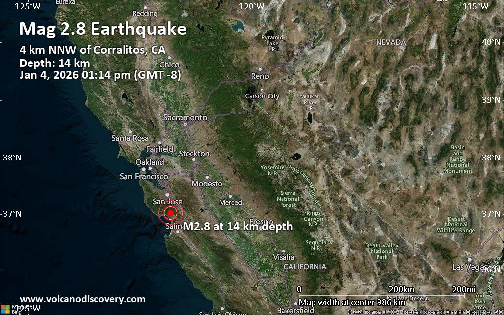 A magnitude 2.8 earthquake near Watsonville, Santa Cruz County, California, USA, was reported only 10 minutes ago by the United States Geological Survey, considered the key international and national agency that monitors seismic activity in the US. The earthquake occurred at a shallow depth of 8.5 miles beneath the epicenter around noon on Sunday, January 4th, 2026, at 1:14 pm local time. The exact magnitude, epicenter, and depth of the quake might be revised within the next few hours or minutes as seismologists review data and refine their calculations, or as other agencies issue their report.
A second report was later issued by The Incorporated Research Institutions for Seismology (IRIS), which listed it as a magnitude 2.8 earthquake as well. A third agency, the European-Mediterranean Seismological Centre (EMSC), reported the same quake at magnitude 2.9.
Towns or cities near the epicenter where the quake might have been felt as very weak shaking include Corralitos (pop. 2,300) located 2 miles from the epicenter, Watsonville (pop. 53,600) 8 miles away, and Live Oak (pop. 17,200) 9 miles away. In Morgan Hill (pop. 42,900, 12 miles away), Santa Cruz (pop. 64,200, 12 miles away), Gilroy (pop. 53,200, 14 miles away), San Jose (pop. 997,400, 23 miles away), Santa Clara (pop. 126,200, 24 miles away), and Salinas (pop. 157,400, 25 miles away), the quake was probably not felt.
Earthquake data: Date & time: Jan 4, 2026 01:14 pm (GMT -8) local time (4 Jan 2026 21:14 GMT)Magnitude: 2.8 Depth: 13.71 km Epicenter latitude / longitude: 37.02°N / 121.82°W  ( Santa Cruz County, California, United States) Primary data source: USGShttps://www.volcanodiscovery.com/earthquake/news/291082/Small-magnitude-28-quake-hits-8-miles-northwest-of-Watsonville-California-United-States-around-noon-.html
|
|


CMS The Best Conveyancing solicitors conveyancing quotes throughout the UK
For any webhosting enquiries please email webmaster@aus-city.com
|
|
Forums60
Topics786,868
Posts821,640
Members2,960
| |
Most Online22,463
May 9th, 2026
|
|
|
|
|
Copyright 1996 - 2026 by David Cottle. Designed by David Bate Jr. All Rights Reserved.
By using this forum, the user agrees not to transfer any data or technical information received under this agreement to any other entity without the express approval of the AUS-CITY Forum Admins and/or authors of individual posts (Forum Admins and DoD/USSPACECOM for the analysis of satellite tracking data).
Two-line elements (TLE) and all other satellite data presented and distributed via this forum and AUS-CITY mailing lists are distributed with permission from DoD/USSTRATCOM.

|

|


 - Click image for larger picture.")


