|
|
|
0 members (),
2,515
guests, and
20
robots. |
|
Key:
Admin,
Global Mod,
Mod
|
|
S |
M |
T |
W |
T |
F |
S |
|
|
|
|
1
|
2
|
3
|
4
|
|
5
|
6
|
7
|
8
|
9
|
10
|
11
|
|
12
|
13
|
14
|
15
|
16
|
17
|
18
|
|
19
|
20
|
21
|
22
|
23
|
24
|
25
|
|
26
|
27
|
28
|
29
|
30
|
31
|
|
|
There are no members with birthdays on this day. |

Volcano earthquake report for Friday, 10 Jul 2026
• Moderate mag. 4.2 earthquake - 133 km northwest of Ternate, Kota Ternate, N...
• World Earthquake Report for Friday, 10 July 2026
• Moderate mag. 4.6 earthquake - 17 km southwest of Comalapa, Estado de Chiap...
• Moderate mag. 4.1 earthquake - Olyutorskiy Rayon, 47 km northwest of Tilich...
• Moderate mag. 4.0 earthquake - Hawke's Bay, New Zealand, on Saturday, Jul 1...
|

#791389
Wed 07 Jan 2026 11:50:PM
|
Joined: Feb 2001
Posts: 678,976
Launch Director
|
OP

Launch Director
Joined: Feb 2001
Posts: 678,976 |
Volcano earthquake report for Wednesday, 7 Jan 2026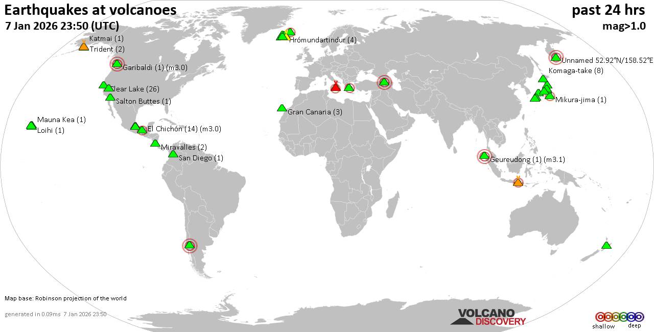 World map showing volcanoes with shallow (less than 50 km) earthquakes within 20 km radius during the past 24 hours on 7 Jan 2026 Number in brackets indicate nr of quakes. Quakes detected near: Agung (1 quake mag 2.3), Akagi (1 quake mag 1.4), Aragats (1 quake mag 3.0), Brennisteinsfjöll (3 quakes between mag 0.5-1.4), Clear Lake (26 quakes between mag 0.3-1.3), Daisen (4 quakes between mag 0.8-1.1)
El Chichón (14 quakes between mag 1.9-3.0), Eldey (2 quakes between mag 1.4-1.7), Etna (4 quakes between mag 1.5-2.4), Garibaldi (1 quake mag 3.0), Geureudong (1 quake mag 3.1), Gran Canaria (3 quakes between mag 1.8-2.1), Hiuchi (4 quakes between mag 0.1-1.1), Hrómundartindur (4 quakes between mag 0.6-1.4), Katla (1 quake mag 1.8), Katmai (1 quake mag 1.3), Komaga-take (8 quakes between mag 0.5-1.1), Kuju (1 quake mag 1.1), Kurikoma (4 quakes between mag 0.2-1.9), Las Cumbres (2 quakes between mag 2.7-2.9), Ljósufjöll (3 quakes between mag 0.5-1.2), Llaima (1 quake mag 3.0), Loihi (1 quake mag 1.7), Mammoth Mountain (1 quake mag 1.4), Mauna Kea (1 quake mag 1.8), Maunaloa (1 quake mag 1.4), Mikura-jima (1 quake mag 2.4), Miravalles (2 quakes between mag 1.8-1.9), Numazawa (1 quake mag 3.0), Pico de Orizaba (2 quakes between mag 2.0-2.3), Prestahnukur (1 quake mag 1.6), Salton Buttes (1 quake mag 1.5), San Diego (1 quake mag 1.5), Sousaki (2 quakes between mag 1.6-2.2), Taupo (1 quake mag 1.8), Tjörnes Fracture Zone (3 quakes between mag 1.0-2.1), Trident (2 quakes between mag 1.0-1.2), Unzen (1 quake mag 1.3), Yake-dake (1 quake mag 2.3) (updated 23h50)
Note: Earthquakes within 20 km from and at depths less than 50 km under active volcanoes are reported. The list is not complete because many volcanoes are not monitored and/or seismic data in high resolution is not available publicly.
Volcanoes with recent earthquakes above magnitude 2 or more than 10 quakes are listed below:
Agung volcano (Bali): magnitude 2.3 earthquakeA magnitude 2.3 earthquake occurred at the volcano 18 hours ago. The quake, which might be volcanic in origin, was located at a depth of 10.00 km depth at 19 km distance NNE from the volcano. Earthquake details: 2.3 quake Bali Sea, 29 km north of Amlapura, Indonesia, Jan 7, 2026 01:55 pm (GMT +8) (19 km NNE) All earthquakes at AgungAragats volcano (Armenia): magnitude 3.0 earthquakeA magnitude 3.0 earthquake occurred at the volcano 37 minutes ago. The quake, which might be volcanic in origin, was located at a depth of 10.00 km depth at 16 km distance ENE from the volcano. Earthquake details: Unconfirmed quake or seismic-like event reported: 26 km southwest of Vanadzor, Lori, Armenia, Jan 8, 2026 03:12 am (GMT +4) (16 km ENE) All earthquakes at AragatsClear Lake volcano (California): 26 earthquakes up to magnitude 1.3Possible earthquake swarm: 26 earthquakes occurred near (under) the volcano during 23 hours, the last being recorded quake 33 minutes ago. Hypocenter depths ranged between 3.94 and 1.35 km. Earthquake details: (only 5 largest) 1.3 quake 9.6 mi southwest of Clearlake, Lake County, California, United States, Jan 7, 2026 01:55 pm (GMT -8) (14 km SSE) 1.2 quake Lake County, 26 mi north of Santa Rosa, Sonoma County, California, United States, Jan 6, 2026 10:58 pm (GMT -8) (17 km S) 1.1 quake 27 mi north of Santa Rosa, Sonoma County, California, United States, Jan 6, 2026 04:21 pm (GMT -8) (17 km S) 1.1 quake Lake County, 25 mi north of Santa Rosa, Sonoma County, California, United States, Jan 7, 2026 04:56 am (GMT -8) (19 km SSE) 1.1 quake Lake County, 27 mi north of Santa Rosa, Sonoma County, California, United States, Jan 6, 2026 08:21 pm (GMT -8) (16 km S) All earthquakes at Clear LakeEl Chichón volcano (Southern Mexico): 14 earthquakes up to magnitude 3.0Possible earthquake swarm: 14 earthquakes occurred near (under) the volcano during 9 hours, the last being recorded quake 15 hours ago. Hypocenter depths ranged between 5.20 and 1.50 km. Earthquake details: (only 5 largest) 3.0 quake Estado de Chiapas, 35 km southwest of Teapa, Estado de Tabasco, Mexico, Jan 7, 2026 01:52 am (GMT -6) (2 km ENE) 2.7 quake Estado de Chiapas, 36 km southwest of Teapa, Estado de Tabasco, Mexico, Jan 6, 2026 09:31 pm (GMT -6) (1 km N) 2.7 quake Estado de Chiapas, 37 km southwest of Teapa, Estado de Tabasco, Mexico, Jan 7, 2026 12:17 am (GMT -6) (1 km NNW) 2.5 quake Estado de Chiapas, 37 km southwest of Teapa, Estado de Tabasco, Mexico, Jan 6, 2026 07:48 pm (GMT -6) (1 km NNW) 2.4 quake Estado de Chiapas, 36 km southwest of Teapa, Estado de Tabasco, Mexico, Jan 6, 2026 06:31 pm (GMT -6) (2 km N) All earthquakes at El ChichónEtna volcano (Italy): 4 earthquakes up to magnitude 2.44 earthquakes occurred near (under) the volcano during 10 hours, the last being recorded quake 9 hours ago. Hypocenter depths ranged between 13.61 and 0.47 km. Earthquake details: 2.4 quake 7.3 km north of Adrano, Catania, Sicily, Italy, Jan 7, 2026 12:57 pm (GMT +1) (17 km W) 1.8 quake 7.9 km northwest of Adrano, Catania, Sicily, Italy, Jan 7, 2026 10:29 am (GMT +1) (18 km W) 1.6 quake 15 km west of Giarre, Catania, Sicily, Italy, Jan 7, 2026 05:22 am (GMT +1) (2 km ESE) 1.5 quake 12 km northwest of Acireale, Catania, Sicily, Italy, Jan 7, 2026 03:40 pm (GMT +1) (10 km SE) All earthquakes at EtnaGaribaldi volcano (Canada): magnitude 3.0 earthquakeA magnitude 3.0 earthquake occurred at the volcano 2 hours ago. The quake, which might be volcanic in origin, was located at a depth of 10.00 km depth at 17 km distance SW from the volcano. Earthquake details: Reported seismic-like event (likely no quake): 3.5 km north of Squamish, Squamish-Lillooetal, British Columbia, Canada, Jan 7, 2026 01:28 pm (GMT -8) (17 km SW) All earthquakes at GaribaldiGeureudong volcano (Sumatra): magnitude 3.1 earthquakeA magnitude 3.1 earthquake occurred at the volcano 13 hours ago. The quake, which might be volcanic in origin, was located at a depth of 6.00 km depth at 10 km distance SW from the volcano. Earthquake details: 3.1 quake Kabupaten Aceh Tengah, 68 km southwest of Lhokseumawe, Indonesia, Jan 7, 2026 05:53 pm (GMT +7) (10 km SW) All earthquakes at GeureudongGran Canaria volcano (Canary Islands): 3 earthquakes up to magnitude 2.13 earthquakes occurred near (under) the volcano during 1 hour 11 minutes, the last being recorded quake 3 hours ago. Hypocenter depths ranged between 18.00 and 2.00 km. Earthquake details: 2.1 quake 8.6 km north of Mogan, Las Palmas, Canary Islands, Spain, Jan 7, 2026 07:21 pm (Universal Time) (17 km SW) 1.9 quake 25 km northwest of San Bartolome de Tirajana, Las Palmas, Canary Islands, Spain, Jan 7, 2026 07:15 pm (Universal Time) (18 km W) 1.8 quake 26 km west of Las Palmas de Gran Canaria, Las Palmas, Canary Islands, Spain, Jan 7, 2026 08:26 pm (Universal Time) (11 km WNW) All earthquakes at Gran CanariaLas Cumbres volcano (Western & Central Mexico): 2 earthquakes up to magnitude 2.92 earthquakes occurred near (under) the volcano during 58 minutes, the last being recorded quake 19 hours ago. Hypocenter depths ranged between 13.80 and 13.50 km. Earthquake details: 2.9 quake 17 km northeast of Ciudad Serdan, Estado de Puebla, Mexico, Jan 6, 2026 10:27 pm (GMT -6) (9 km WSW) 2.7 quake 15 km northeast of Ciudad Serdan, Estado de Puebla, Mexico, Jan 6, 2026 09:28 pm (GMT -6) (11 km SW) All earthquakes at Las CumbresLlaima volcano (Central Chile and Argentina): magnitude 3.0 earthquakeA magnitude 3.0 earthquake occurred at the volcano 21 hours ago. The quake, which might be volcanic in origin, was located at a depth of 10.00 km depth at 18 km distance S from the volcano. Earthquake details: Reported seismic-like event (likely no quake): 27 km east of Cunco, Provincia de Cautin, Region de la Araucania, Chile, Jan 7, 2026 12:10 am (GMT -3) (18 km S) All earthquakes at LlaimaMikura-jima volcano (Izu Islands): magnitude 2.4 earthquakeA magnitude 2.4 earthquake occurred at the volcano 23 hours ago. The quake, which might be volcanic in origin, was located at a depth of 16.40 km depth at 19 km distance WSW from the volcano. Earthquake details: 2.4 quake Philippine Sea, 31 km south of Miyake, Tokyo, Japan, Jan 7, 2026 10:04 am (GMT +9) (19 km WSW) All earthquakes at Mikura-jimaNumazawa volcano (Honshu): magnitude 3.0 earthquakeA magnitude 3.0 earthquake occurred at the volcano 10 hours ago. The quake, which might be volcanic in origin, was located at a depth of 10.00 km depth at 15 km distance SE from the volcano. Earthquake details: Reported seismic-like event (likely no quake): 25 km southwest of Aizu-Wakamatsu, Fukushima, Japan, Jan 7, 2026 11:09 pm (GMT +9) (15 km SE) All earthquakes at NumazawaPico de Orizaba volcano (Western & Central Mexico): 2 earthquakes up to magnitude 2.32 earthquakes occurred near (under) the volcano during 5 hours, the last being recorded quake 18 hours ago. Hypocenter depths ranged between 8.80 and 6.20 km. Earthquake details: 2.3 quake 13 km east of Ciudad Serdan, Estado de Puebla, Mexico, Jan 7, 2026 12:05 am (GMT -6) (7 km SW) 2.0 quake 30 km northwest of Orizaba, Estado de Veracruz-Llave, Mexico, Jan 6, 2026 06:54 pm (GMT -6) (8 km NNE) All earthquakes at Pico de OrizabaSousaki volcano (Greece): 2 earthquakes up to magnitude 2.22 earthquakes occurred near (under) the volcano during 2 hours, the last being recorded quake 21 hours ago. Hypocenter depths ranged between 10.00 and 5.00 km. Earthquake details: 2.2 quake 14 km east of Corinth, Nomos Korinthias, Peloponnese, Greece, Jan 7, 2026 04:42 am (GMT +2) (4 km NNE) 1.6 quake Aegean Sea, 18 km west of Nisi Salamina Island, Nomos Attikis, Attica, Greece, Jan 7, 2026 02:39 am (GMT +2) (19 km ENE) All earthquakes at SousakiTjörnes Fracture Zone volcano (Iceland): 3 earthquakes up to magnitude 2.13 earthquakes occurred near (under) the volcano during 4 hours, the last being recorded quake 15 hours ago. Hypocenter depths ranged between 19.20 and 9.40 km. Earthquake details: 2.1 quake 20.0 km WNW of Kópasker Jan 7, 2026 04:24 am (Universal Time) (11 km ENE) 1.2 quake 13.7 km WSW of Kópasker Jan 7, 2026 08:39 am (Universal Time) (19 km ESE) 1.0 quake 19.7 km W of Kópasker Jan 7, 2026 04:37 am (Universal Time) (10 km ENE) All earthquakes at Tjörnes Fracture ZoneUnnamed 52.92°N/158.52°E volcano (Southern Kamchatka): magnitude 3.0 earthquakeA magnitude 3.0 earthquake occurred at the volcano 23 hours ago. The quake, which might be volcanic in origin, was located at a depth of 10.00 km depth at 17 km distance NNE from the volcano. Earthquake details: Reported seismic-like event (likely no quake): 2.8 km southeast of Petropavlovsk-Kamchatskiy, Kamchatka, Russia, Jan 7, 2026 01:11 pm (GMT +12) (17 km NNE) All earthquakes at Unnamed 52.92°N/158.52°EYake-dake volcano (Honshu): magnitude 2.3 earthquakeA magnitude 2.3 earthquake occurred at the volcano 23 hours ago. The quake, which might be volcanic in origin, was located at a depth of 4.50 km depth at 7 km distance E from the volcano. Earthquake details: 2.3 quake 21 km west of Azumino, Nagano, Japan, Jan 7, 2026 10:17 am (GMT +9) (7 km E) All earthquakes at Yake-dakehttps://www.volcanodiscovery.com/earthquakes-volcanoes/news/291244/Volcano-earthquake-report-for-Wednesday-7-Jan-2026.html
|
|


CMS The Best Conveyancing solicitors conveyancing quotes throughout the UK
For any webhosting enquiries please email webmaster@aus-city.com
|
|
Forums60
Topics789,850
Posts824,628
Members2,960
| |
Most Online102,106
Jul 10th, 2026
|
|
|
|
|
Copyright 1996 - 2026 by David Cottle. Designed by David Bate Jr. All Rights Reserved.
By using this forum, the user agrees not to transfer any data or technical information received under this agreement to any other entity without the express approval of the AUS-CITY Forum Admins and/or authors of individual posts (Forum Admins and DoD/USSPACECOM for the analysis of satellite tracking data).
Two-line elements (TLE) and all other satellite data presented and distributed via this forum and AUS-CITY mailing lists are distributed with permission from DoD/USSTRATCOM.

|

|


 - Click image for larger picture.")


