|
|
|
0 members (),
1,595
guests, and
22
robots. |
|
Key:
Admin,
Global Mod,
Mod
|
|
S |
M |
T |
W |
T |
F |
S |
|
|
|
|
|
1
|
2
|
3
|
|
4
|
5
|
6
|
7
|
8
|
9
|
10
|
|
11
|
12
|
13
|
14
|
15
|
16
|
17
|
|
18
|
19
|
20
|
21
|
22
|
23
|
24
|
|
25
|
26
|
27
|
28
|
29
|
30
|
31
|
|
There are no members with birthdays on this day. |
|
|
hii
by Anonymous - Fri 09 Jan 2026 11:35:AM
|
|
|
|
|
|
|
|
|
|
|
|
|
|
|
|
|
|
|
Joined: Feb 2001
Posts: 381,904
Launch Director
|
OP

Launch Director
Joined: Feb 2001
Posts: 381,904 |
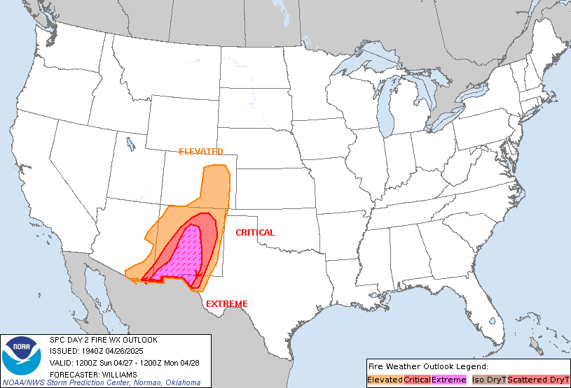
SPC Day 2 Fire Weather OutlookSPC Day 2 Fire Weather Outlook 
Day 2 Fire Weather Outlook
NWS Storm Prediction Center Norman OK
0120 PM CST Thu Jan 08 2026

Valid 091200Z - 101200Z

The Elevated area was expanded in the Big Bend and into northwest
Texas, while it was adjusted from Del Rio to Laredo into the western
Hill Country based on the latest high-resolution forecast guidance.
West-northwest sustained winds of 15-25 mph and minimum RH of 15-25%
are likely from the Big Bend into northwest Texas and the western
Hill Country during the afternoon and early evening. Winds will
shift to north-northwest as another cold front drops south across
Texas during the evening and overnight. Locally elevated to elevated
conditions are expected in the evening across the western Hill
Country/vicinity and shifting southwards into portions of south
Texas overnight, mostly focused closer to the Rio Grande.

Gusty and dry north-northeast winds are expected again across
southern California, but recent precipitation has left fuel moisture
above normal and well above critical thresholds.

..Nauslar.. 01/08/2026

.PREV DISCUSSION... /ISSUED 0153 AM CST Thu Jan 08 2026/

...Synopsis...
A mid-level trough will gradually traverse the central CONUS today,
supporting the development of a weak surface low over the Sabine
River Valley, with a surface cold front sweeping across the southern
Plains tomorrow (Friday). To the west of the aforementioned low and
ahead of the surface cold front, dry downslope flow is expected
across much of western Texas Friday afternoon for at least a few
hours. 15-25 mph sustained westerly surface winds will overlap with
15-20 percent RH. Elevated highlights have been added to account for
these conditions. There are questions regarding how appreciable
rainfall accumulations will be in west-central Texas, where Elevated
highlights may need adjustments in future outlooks.

...Please see www.spc.noaa.gov/fire for graphic product...
Read morehttps://www.spc.noaa.gov/products/fire_wx/fwdy2.html
|
|


CMS The Best Conveyancing solicitors conveyancing quotes throughout the UK
For any webhosting enquiries please email webmaster@aus-city.com
|
|
Forums60
Topics755,246
Posts789,945
Members2,958
| |
Most Online12,408
Dec 19th, 2025
|
|
|
|
|
Copyright 1996 - 2026 by David Cottle. Designed by David Bate Jr. All Rights Reserved.
By using this forum, the user agrees not to transfer any data or technical information received under the agreement, to any other entity without the express approval of the AUS-CITY Forum Admins and/or authors of individual posts (Forum Admins and DoD/USSPACECOM for the analysis of satellite tracking data).
Two-line elements (TLE) and all other satellite data presented and distributed via this forum and e-mail lists of AUS-CITY are distributed with permission from DoD/USSTRATCOM.


Reprise Hosting


|

|