|
|
|
0 members (),
1,593
guests, and
41
robots. |
|
Key:
Admin,
Global Mod,
Mod
|
|
S |
M |
T |
W |
T |
F |
S |
|
|
|
|
1
|
2
|
3
|
4
|
|
5
|
6
|
7
|
8
|
9
|
10
|
11
|
|
12
|
13
|
14
|
15
|
16
|
17
|
18
|
|
19
|
20
|
21
|
22
|
23
|
24
|
25
|
|
26
|
27
|
28
|
29
|
30
|
31
|
|
|
There are no members with birthdays on this day. |
|
|
|
|
|
|
|
|
|
|
|
|
|
|
|
|
Mini-Heap
by Alisa - Wed 22 Jul 2026 01:04:PM
|
|
|
|
|
|
|

Volcano earthquake report for Friday, 10 Jul 2026
• Moderate mag. 4.2 earthquake - 133 km northwest of Ternate, Kota Ternate, N...
• World Earthquake Report for Friday, 10 July 2026
• Moderate mag. 4.6 earthquake - 17 km southwest of Comalapa, Estado de Chiap...
• Moderate mag. 4.1 earthquake - Olyutorskiy Rayon, 47 km northwest of Tilich...
• Moderate mag. 4.0 earthquake - Hawke's Bay, New Zealand, on Saturday, Jul 1...
|

#792504
Mon 12 Jan 2026 07:25:PM
|
Joined: Feb 2001
Posts: 678,976
Launch Director
|
OP

Launch Director
Joined: Feb 2001
Posts: 678,976 |
Moderate 4.8 quake hits near Sentani, Kabupaten Jayapura, Provinsi Papua, Indonesia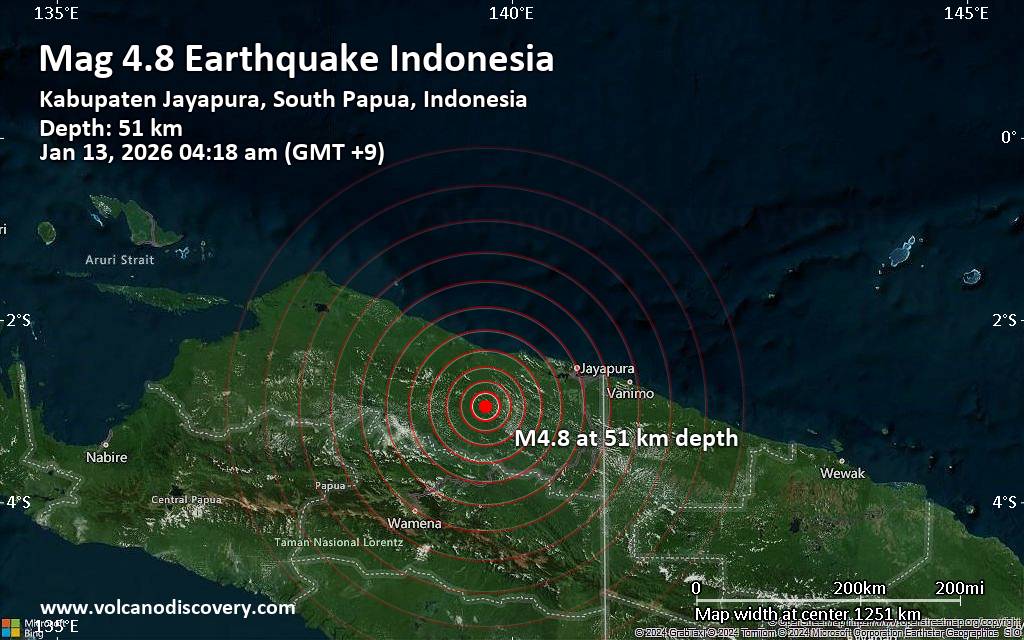 A moderately shallow magnitude 4.8 earthquake was reported early morning near Sentani, Kabupaten Jayapura, Provinsi Papua, Indonesia.
According to Indonesia's Meteorology, Climatology, and Geophysical Agency, the quake hit on Tuesday, January 13th, 2026, at 4:18 am local time at a moderately shallow depth of 51. km. The exact magnitude, epicenter, and depth of the quake might be revised within the next few hours or minutes as seismologists review data and refine their calculations, or as other agencies issue their report.
A second report was later issued by the citizen-seismograph network of RaspberryShake, which listed it as a magnitude 4.8 earthquake as well.
Towns or cities near the epicenter where the quake might have been felt as very weak shaking include Elelim (pop. 5,900) located 90 km from the epicenter, Sentani (pop. 44,800) 99 km away, Kobakma (pop. 13,100) 107 km away, and Abepura (pop. 62,200) 110 km away.
VolcanoDiscovery will automatically update magnitude and depth if these change and follow up if other significant news about the quake become available. If you’re in the area, please send us your experience through our reporting mechanism, either online or via our mobile app. This will help us provide more first-hand updates to anyone around the globe who wants to know more about this quake.
Earthquake data: Date & time: Jan 13, 2026 04:18 am (Jayapura time) local time (12 Jan 2026 19:18 GMT)Magnitude: 4.8 Depth: 51.00 km Epicenter latitude / longitude: 2.95°S / 139.71°E  ( Kabupaten Jayapura, South Papua, Indonesia) Primary data source: BMKGhttps://www.volcanodiscovery.com/earthquake/news/291789/Moderate-48-quake-hits-near-Sentani-Kabupaten-Jayapura-Provinsi-Papua-Indonesia.html
|
|


CMS The Best Conveyancing solicitors conveyancing quotes throughout the UK
For any webhosting enquiries please email webmaster@aus-city.com
|
|
Forums60
Topics790,239
Posts825,019
Members2,960
| |
Most Online102,106
Jul 10th, 2026
|
|
|
|
|
Copyright 1996 - 2026 by David Cottle. Designed by David Bate Jr. All Rights Reserved.
By using this forum, the user agrees not to transfer any data or technical information received under this agreement to any other entity without the express approval of the AUS-CITY Forum Admins and/or authors of individual posts (Forum Admins and DoD/USSPACECOM for the analysis of satellite tracking data).
Two-line elements (TLE) and all other satellite data presented and distributed via this forum and AUS-CITY mailing lists are distributed with permission from DoD/USSTRATCOM.

|

|


 - Click image for larger picture.")


