|
0 members (),
1,178
guests, and
24
robots. |
|
Key:
Admin,
Global Mod,
Mod
|
|
S |
M |
T |
W |
T |
F |
S |
|
|
|
|
|
|
|
1
|
|
2
|
3
|
4
|
5
|
6
|
7
|
8
|
|
9
|
10
|
11
|
12
|
13
|
14
|
15
|
|
16
|
17
|
18
|
19
|
20
|
21
|
22
|
|
23
|
24
|
25
|
26
|
27
|
28
|
29
|
|
30
|
31
|
|
|
|
|
|
|
There are no members with birthdays on this day. |
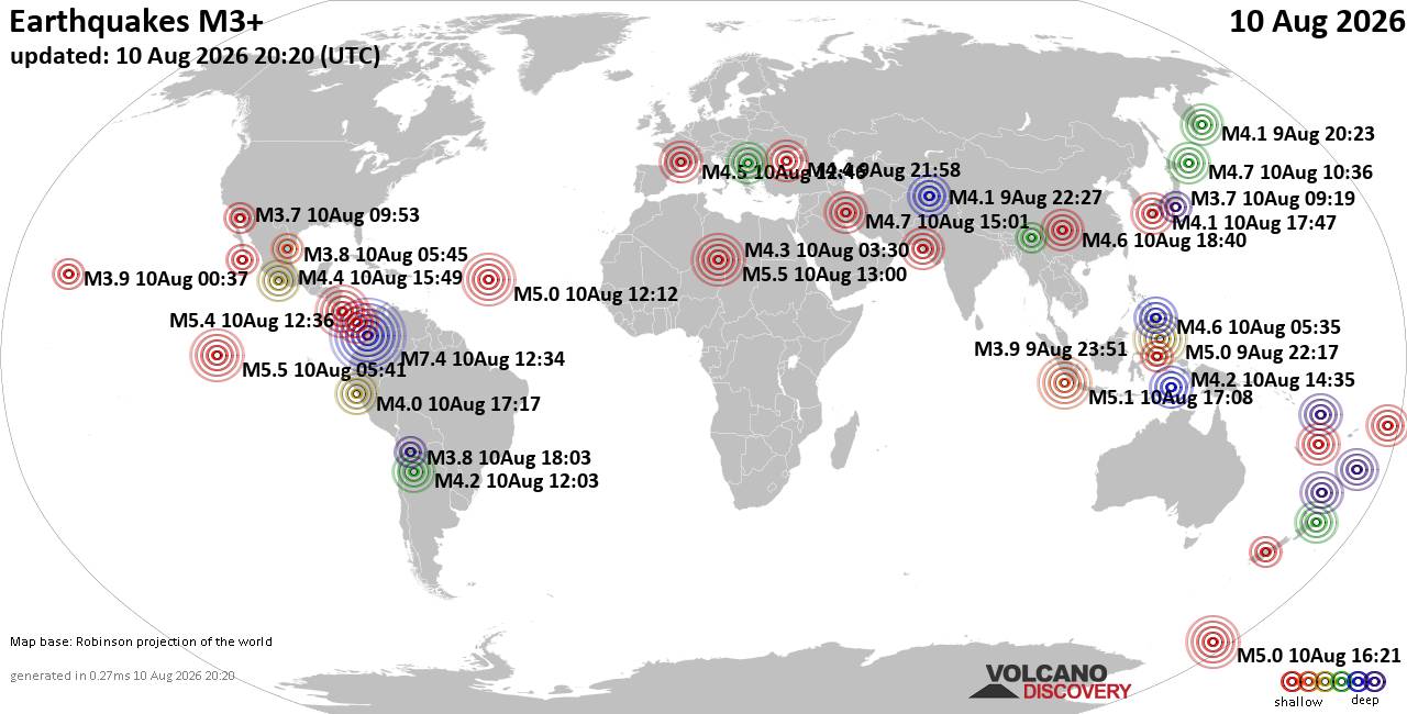
World Earthquake Report for Monday, 10 August 2026
• Volcano earthquake report for Monday, 10 Aug 2026
• Moderate mag. 4.0 earthquake - Zangilan Rayon, 58 km southwest of Ganja, Ga...
• Moderate mag. 4.6 earthquake - 31 km northeast of Xunchang, Sichuan, China,...
• Moderate mag. 4.2 earthquake - New Zealand on Tuesday, Aug 11, 2026, at 06:...
• World Earthquake Report for August 2026
|

#792524
Mon 12 Jan 2026 07:53:PM
|
Joined: Feb 2001
Posts: 678,976
Launch Director
|
OP

Launch Director
Joined: Feb 2001
Posts: 678,976 |
SPC Day 2 Fire Weather OutlookSPC Day 2 Fire Weather Outlook 
Day 2 Fire Weather Outlook
NWS Storm Prediction Center Norman OK
0152 PM CST Mon Jan 12 2026

Valid 131200Z - 141200Z

...Central High Plains...
North-northwesterly flow aloft attributed to a deepening upper-level
trough across the eastern U.S. will increase through Tuesday across
the Southern Rockies and adjacent High Plains. The upper-level
support along with ongoing lee troughing will promote breezy
northwest winds of 10-20 mph across portions of central High Plains
Tuesday. Increasing cloud cover will limit boundary layer mixing to
a degree but relative humidity should still fall to around 20%
across northeastern CO and vicinity. This coupled with breezy winds
and dry/dormant fuels will likely support elevated fire weather
threat for northeastern CO, far southeastern WY and southwestern NE
Panhandle, where Elevated highlights have been added.

...Southern Plains...
Limited magnitude of southwest winds associated with a surface
trough extending southwest from the Great Lakes region will be a
primary mitigating factor in a broader fire weather threat across
the Southern Plains on Tuesday. Localized elevated fire weather
conditions are still possible as afternoon RH falls below 20% across
northwestern Texas and southwestern OK where winds of up to 15 mph
amid drier fuels are expected.

...Southeast...
A residual dry air mass will persist across the Southeastern U.S.
Tuesday where RH will fall to as low as 20% on Tuesday. Although
limited recent rainfall has promoted drier fuels across portions of
southern GA and the Carolinas, a weak surface pressure gradient will
restrict winds to 10 mph or less across much of the region Tuesday
afternoon, limiting a broader fire weather concern across the
Southeast.

..Williams.. 01/12/2026

.PREV DISCUSSION... /ISSUED 0207 AM CST Mon Jan 12 2026/

...Synopsis...
Broad northwesterly flow will persist over much of the CONUS as
eastern US troughing continues to intensify. A stronger shortwave
within the broad troughing will move southward over the central US
Tuesday. An accompanying cold front will also move southward with
strong surface winds along and behind it.

..Central High Plains...
As the upper trough over the East deepens, flow aloft will turn more
northerly ahead of the strong shortwave trough. This, along with the
surface cold front will support strong northerly/northwesterly
surface winds across parts of WY northern CO and NE Tuesday. At
least brief dry and breezy conditions are possible in this region
owing to the downslope winds. Currently, RH values appear only
modest owing to cloud cover and rapidly decreasing temperatures.
However, very dry fine fuels and in some dry/breezy conditions could
support brief locally elevated fire-weather potential Tuesday
afternoon before diminishing overnight.

...Southern Plains...
A period of dry southwesterly flow is forecast to develop across the
southern Plains D2/Tuesday as upper troughing intensifies over the
northeastern US. Winds are not forecast to be overly strong, but
gusts around 15 mph are possible. These winds, overlapping with low
RH of 15-20% during the afternoon could support some localized
fire-weather concerns. However, recent rainfall should preclude
broader potential.

...Southeast...
Dry conditions will likely persist over the Southeast as surface
high pressure settles south of the deepening low in the wake of an
earlier cold front. While strong winds appear unlikely, RH values
below 35% and drier fuels could support some brief localized
fire-weather concerns, especially across parts of coastal GA and the
Carolinas where little rainfall has occurred recently.

...Please see www.spc.noaa.gov/fire for graphic product...
Read morehttps://www.spc.noaa.gov/products/fire_wx/fwdy2.html
|
|



CMS The Best Conveyancing solicitors conveyancing quotes throughout the UK
For any webhosting enquiries please email webmaster@aus-city.com
|
|
Forums60
Topics796,363
Posts831,153
Members2,960
| |
Most Online102,106
Jul 10th, 2026
|
|
|





































