|
|
|
0 members (),
1,746
guests, and
31
robots. |
|
Key:
Admin,
Global Mod,
Mod
|
|
S |
M |
T |
W |
T |
F |
S |
|
|
|
|
1
|
2
|
3
|
4
|
|
5
|
6
|
7
|
8
|
9
|
10
|
11
|
|
12
|
13
|
14
|
15
|
16
|
17
|
18
|
|
19
|
20
|
21
|
22
|
23
|
24
|
25
|
|
26
|
27
|
28
|
29
|
30
|
31
|
|
|
There are no members with birthdays on this day. |

Volcano earthquake report for Friday, 10 Jul 2026
• Moderate mag. 4.2 earthquake - 133 km northwest of Ternate, Kota Ternate, N...
• World Earthquake Report for Friday, 10 July 2026
• Moderate mag. 4.6 earthquake - 17 km southwest of Comalapa, Estado de Chiap...
• Moderate mag. 4.1 earthquake - Olyutorskiy Rayon, 47 km northwest of Tilich...
• Moderate mag. 4.0 earthquake - Hawke's Bay, New Zealand, on Saturday, Jul 1...
|

#793515
Fri 16 Jan 2026 10:25:PM
|
Joined: Feb 2001
Posts: 678,976
Launch Director
|
OP

Launch Director
Joined: Feb 2001
Posts: 678,976 |
Significant magnitude 5.2 quake hits 40 km south of Angoram, Papua New Guinea in the morning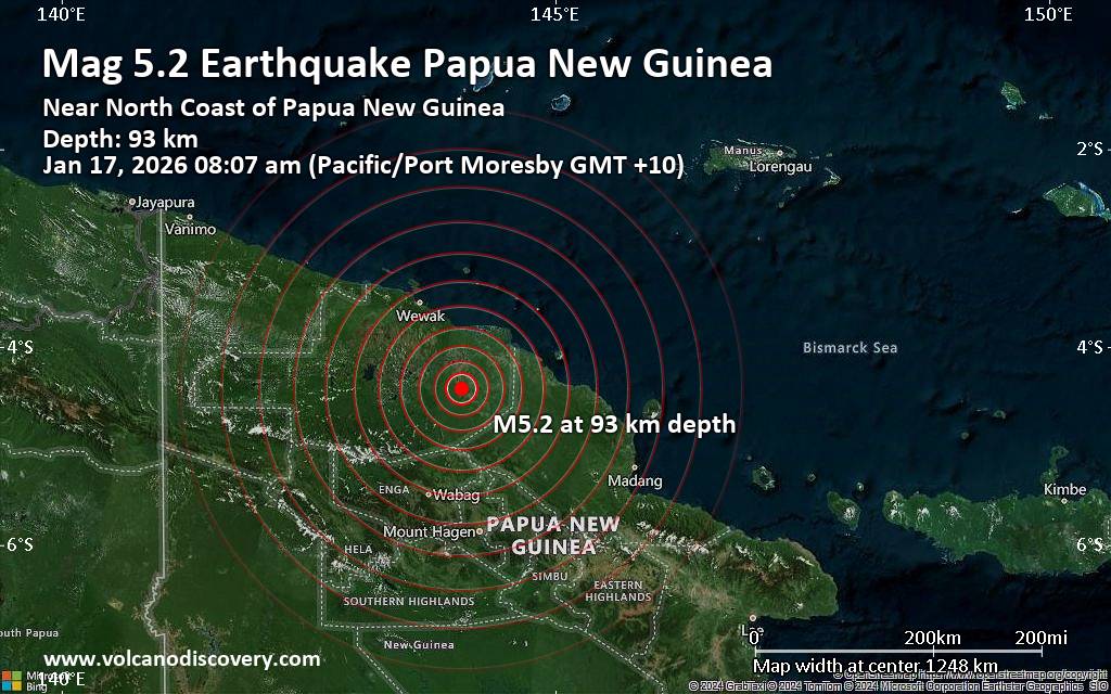 Just 17 minutes ago, a 5.2-magnitude earthquake struck near Angoram, East Sepik Province, Papua New Guinea. The tremor was recorded in the morning on Saturday, January 17th, 2026, at 8:07 am local time, at an intermediate depth of 93. km below the surface.
The event was filed by Indonesia's Meteorology, Climatology, and Geophysical Agency, the first seismological agency to report it.
Our monitoring service identified a second report from the citizen-seismograph network of RaspberryShake which listed the quake at magnitude 4.9. A third agency, the German Research Centre for Geosciences (GFZ), reported the same quake at magnitude 4.8.
Based on the preliminary seismic data, the quake should not have caused any significant damage, but was probably felt by many people as light vibration in the area of the epicenter.
Weak shaking might have been felt in Angoram (pop. 1,600) located 40 km from the epicenter, Wewak (pop. 18,200) 107 km away, and Wewak (pop. 18,200) 107 km away.
VolcanoDiscovery will automatically update magnitude and depth if these change and follow up if other significant news about the quake become available. If you’re in the area, please send us your experience through our reporting mechanism, either online or via our mobile app. This will help us provide more first-hand updates to anyone around the globe who wants to know more about this quake.
Earthquake data: Date & time: Jan 17, 2026 08:07 am (Port Moresby time) local time (16 Jan 2026 22:07 GMT)Magnitude: 5.2 Depth: 93.00 km Epicenter latitude / longitude: 4.42°S / 144.05°E  ( East Sepik Province, Papua New Guinea) Primary data source: BMKGhttps://www.volcanodiscovery.com/earthquake/news/292107/Significant-magnitude-52-quake-hits-40-km-south-of-Angoram-Papua-New-Guinea-in-the-morning-.html
|
|


CMS The Best Conveyancing solicitors conveyancing quotes throughout the UK
For any webhosting enquiries please email webmaster@aus-city.com
|
|
Forums60
Topics787,680
Posts822,454
Members2,960
| |
Most Online102,106
Yesterday at 06:57 PM
|
|
|
|
|
Copyright 1996 - 2026 by David Cottle. Designed by David Bate Jr. All Rights Reserved.
By using this forum, the user agrees not to transfer any data or technical information received under this agreement to any other entity without the express approval of the AUS-CITY Forum Admins and/or authors of individual posts (Forum Admins and DoD/USSPACECOM for the analysis of satellite tracking data).
Two-line elements (TLE) and all other satellite data presented and distributed via this forum and AUS-CITY mailing lists are distributed with permission from DoD/USSTRATCOM.

|

|


 - Click image for larger picture.")


