|
|
|
0 members (),
992
guests, and
24
robots. |
|
Key:
Admin,
Global Mod,
Mod
|
|
S |
M |
T |
W |
T |
F |
S |
|
|
|
|
|
1
|
2
|
3
|
|
4
|
5
|
6
|
7
|
8
|
9
|
10
|
|
11
|
12
|
13
|
14
|
15
|
16
|
17
|
|
18
|
19
|
20
|
21
|
22
|
23
|
24
|
|
25
|
26
|
27
|
28
|
29
|
30
|
31
|
|
There are no members with birthdays on this day. |
|
|
Joined: Feb 2001
Posts: 381,904
Launch Director
|
OP

Launch Director
Joined: Feb 2001
Posts: 381,904 |
Significant 5.3 quake hits near Ha'atu'a, 'Eua fo'ou, Eua, Tonga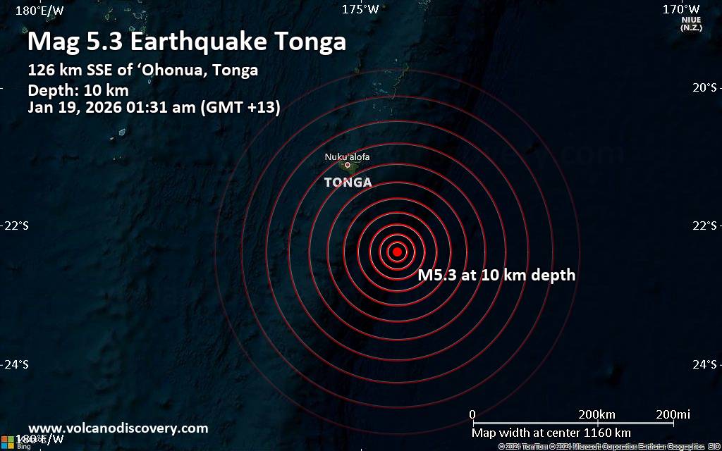 The United States Geological Survey reported a magnitude 5.3 quake in Tonga near Ha'atu'a, 'Eua fo'ou, Eua, 37 minutes ago. The earthquake hit early morning on Monday, January 19th, 2026, at 1:31 am local time at a shallow depth of 10. km. Magnitude and other quake parameters can still change in the coming hours as the agency continues to process seismic data.
A second report was later issued by Geoscience Australia (GeoAu), which listed it as a magnitude 5.3 earthquake as well. Other agencies reporting the same quake include The Incorporated Research Institutions for Seismology (IRIS) at magnitude 5.3, the European-Mediterranean Seismological Centre (EMSC) at magnitude 5.3, France's Réseau National de Surveillance Sismique (RéNaSS) at magnitude 5.1, the citizen-seismograph network of RaspberryShake at magnitude 5.3, and the German Research Centre for Geosciences (GFZ) at magnitude 5.3.
Based on the preliminary seismic data, the quake should not have caused any significant damage, but was probably felt by many people as light vibration in the area of the epicenter.
Weak shaking might have been felt in Ha'atu'a (pop. 490) located 124 km from the epicenter, and 'Ohonua (pop. 1,500) 127 km away.
VolcanoDiscovery will automatically update magnitude and depth if these change and follow up if other significant news about the quake become available. If you’re in the area, please send us your experience through our reporting mechanism, either online or via our mobile app. This will help us provide more first-hand updates to anyone around the globe who wants to know more about this quake.
Earthquake data: Date & time: Jan 19, 2026 01:31 am (GMT +13) local time (18 Jan 2026 12:31 GMT)Magnitude: 5.3 Depth: 10.00 km Epicenter latitude / longitude: 22.38°S / 174.44°W  ( Tonga) Primary data source: USGShttps://www.volcanodiscovery.com/earthquake/news/292256/Significant-53-quake-hits-near-Ha-atu-a-Eua-fo-ou-Eua-Tonga.html
|
|


CMS The Best Conveyancing solicitors conveyancing quotes throughout the UK
For any webhosting enquiries please email webmaster@aus-city.com
|
|
Forums60
Topics757,207
Posts791,913
Members2,958
| |
Most Online17,963
Jan 15th, 2026
|
|
|
|
|
Copyright 1996 - 2026 by David Cottle. Designed by David Bate Jr. All Rights Reserved.
By using this forum, the user agrees not to transfer any data or technical information received under the agreement, to any other entity without the express approval of the AUS-CITY Forum Admins and/or authors of individual posts (Forum Admins and DoD/USSPACECOM for the analysis of satellite tracking data).
Two-line elements (TLE) and all other satellite data presented and distributed via this forum and e-mail lists of AUS-CITY are distributed with permission from DoD/USSTRATCOM.

Reprise Hosting

|

|


 - Click image for larger picture.")


