|
|
|
1 members (Alisa),
1,117
guests, and
22
robots. |
|
Key:
Admin,
Global Mod,
Mod
|
|
S |
M |
T |
W |
T |
F |
S |
|
|
|
|
1
|
2
|
3
|
4
|
|
5
|
6
|
7
|
8
|
9
|
10
|
11
|
|
12
|
13
|
14
|
15
|
16
|
17
|
18
|
|
19
|
20
|
21
|
22
|
23
|
24
|
25
|
|
26
|
27
|
28
|
29
|
30
|
31
|
|
|
There are no members with birthdays on this day. |
|
|
|
|
|
|
|
|
|
|
by Webmaster - Thu 02 Jul 2026 06:04:PM
|
by Webmaster - Thu 02 Jul 2026 06:04:PM
|
by Webmaster - Thu 02 Jul 2026 06:04:PM
|
|
|
|
|
|
|
|
|

World Earthquake Report for July 2026
• World Earthquake Report for Thursday, 2 July 2026
• Volcano earthquake report for Thursday, 2 Jul 2026
• Small magnitude 3.2 quake hits 31 km west of Bergen, Norway early evening
• Moderate mag. 4.0 earthquake - 44 km northwest of Ancud, Provincia de Chilo...
• Moderate mag. 4.7 earthquake - Philippine Sea, 50 km northwest of Yonaguni-...
|

#794112
Tue 20 Jan 2026 03:58:PM
|
Joined: Feb 2001
Posts: 678,976
Launch Director
|
OP

Launch Director
Joined: Feb 2001
Posts: 678,976 |
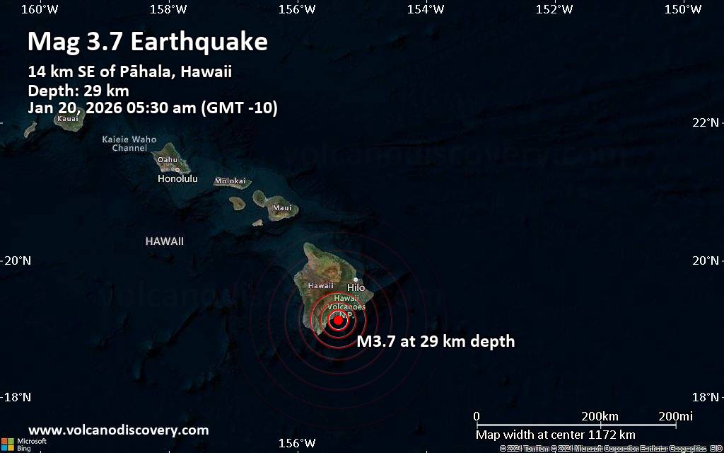
Magnitude 3.7 earthquake strikes near Hilo, Hawaii County, Hawaii, USAJust 27 minutes ago, a 3.7-magnitude earthquake struck near Hilo, Hawaii County, Hawaii, USA. The tremor was recorded early morning on Tuesday, January 20th, 2026, at 5:30 am local time, at a shallow depth of 18 miles below the surface.
The event was filed by the United States Geological Survey, the first seismological agency to report it.
Towns or cities near the epicenter where the quake might have been felt as very weak shaking include Pāhala (pop. 1,400) located 9 miles from the epicenter, Discovery Harbor (pop. 1,200) 18 miles away, Volcano (pop. 2,600) 24 miles away, Hawaiian Ocean View (pop. 4,400) 26 miles away, Fern Forest (pop. 1,200) 28 miles away, Eden Roc (pop. 1,400) 31 miles away, and Mountain View (pop. 3,900) 34 miles away. In Hawaiian Paradise Park (pop. 11,400, 41 miles away), and Hilo (pop. 43,300, 45 miles away), the quake was probably not felt.
Earthquake data: Date & time: Jan 20, 2026 05:30 am (GMT -10) local time (20 Jan 2026 15:30 GMT)Magnitude: 3.7 Depth: 29.01 km Epicenter latitude / longitude: 19.13°N / 155.37°W  (Hawaii, Hawaii, United States) Primary data source: USGShttps://www.volcanodiscovery.com/earthquake/news/292439/Magnitude-37-earthquake-strikes-near-Hilo-Hawaii-County-Hawaii-USA.html
|
|


CMS The Best Conveyancing solicitors conveyancing quotes throughout the UK
For any webhosting enquiries please email webmaster@aus-city.com
|
|
Forums60
Topics785,957
Posts820,727
Members2,960
| |
Most Online22,463
May 9th, 2026
|
|
|
|
|
Copyright 1996 - 2026 by David Cottle. Designed by David Bate Jr. All Rights Reserved.
By using this forum, the user agrees not to transfer any data or technical information received under this agreement to any other entity without the express approval of the AUS-CITY Forum Admins and/or authors of individual posts (Forum Admins and DoD/USSPACECOM for the analysis of satellite tracking data).
Two-line elements (TLE) and all other satellite data presented and distributed via this forum and AUS-CITY mailing lists are distributed with permission from DoD/USSTRATCOM.

|

|


 - Click image for larger picture.")


