|
|
|
0 members (),
3,386
guests, and
26
robots. |
|
Key:
Admin,
Global Mod,
Mod
|
|
S |
M |
T |
W |
T |
F |
S |
|
|
|
|
|
1
|
2
|
3
|
|
4
|
5
|
6
|
7
|
8
|
9
|
10
|
|
11
|
12
|
13
|
14
|
15
|
16
|
17
|
|
18
|
19
|
20
|
21
|
22
|
23
|
24
|
|
25
|
26
|
27
|
28
|
29
|
30
|
31
|
|
|
Joined: Feb 2001
Posts: 381,904
Launch Director
|
OP

Launch Director
Joined: Feb 2001
Posts: 381,904 |
Magnitude 6.0 earthquake strikes near Dinaig, Maguindanao del Norte, Autonomous Region in Muslim Mindanao, Philippines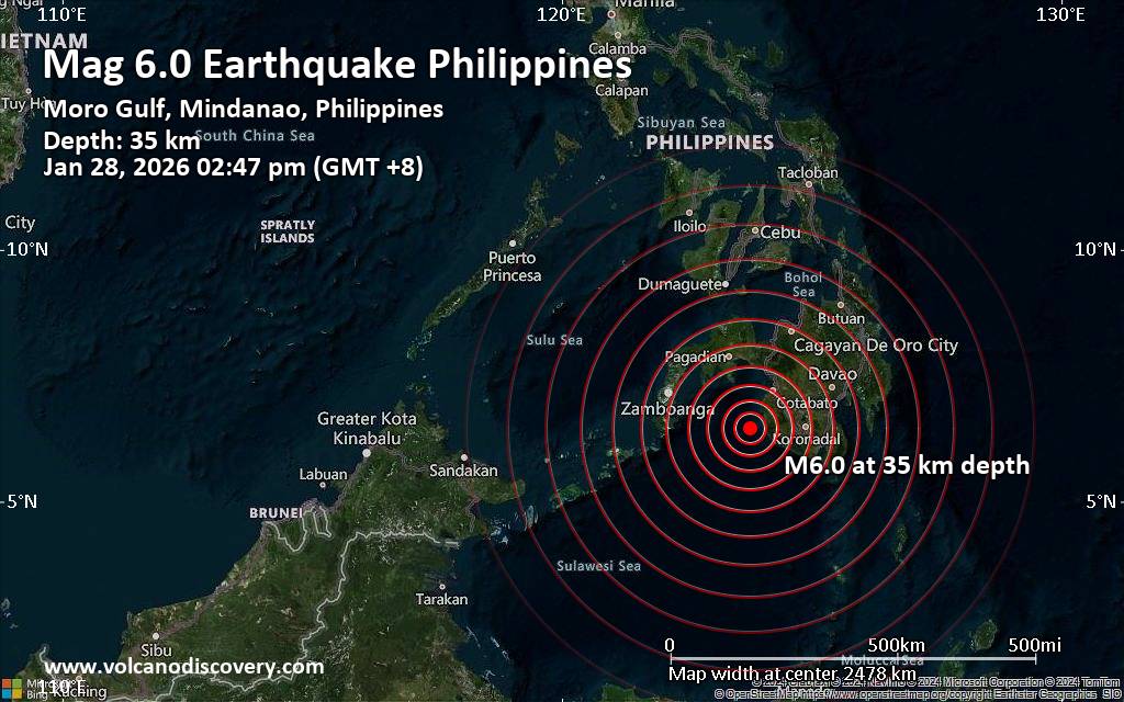 Just 7 minutes ago, a 6.0-magnitude earthquake struck near Dinaig, Maguindanao del Norte, Autonomous Region in Muslim Mindanao, Philippines. The tremor was recorded early afternoon on Wednesday, January 28th, 2026, at 2:47 pm local time, at a moderately shallow depth of 35. km below the surface.
The event was filed by the European-Mediterranean Seismological Centre (EMSC), the first seismological agency to report it.
Our monitoring service identified a second report from the citizen-seismograph network of RaspberryShake which listed the quake at magnitude 6.0 as well. A third agency, the German Research Centre for Geosciences (GFZ), reported the same quake at magnitude 6.0.
Based on the preliminary seismic data, the quake was probably felt by many people in the area of the epicenter. It should not have caused significant damage, other than objects falling from shelves, broken windows, etc.
In Kalamansig (pop. 12,800) located 34 km from the epicenter, Maganoy (pop. 17,400) 88 km away, Laguilayan (pop. 17,800) 88 km away, Dinaig (pop. 116,800) 93 km away, Isulan (pop. 101,500) 95 km away, Norala (pop. 48,500) 100 km away, Cotabato (pop. 383,400) 100 km away, and Koronadal (pop. 201,800) 120 km away, the quake should have been felt as light shaking.
VolcanoDiscovery will automatically update magnitude and depth if these change and follow up if other significant news about the quake become available. If you’re in the area, please send us your experience through our reporting mechanism, either online or via our mobile app. This will help us provide more first-hand updates to anyone around the globe who wants to know more about this quake.
Earthquake data: Date & time: Jan 28, 2026 06:47 am (Universal Time) local time (28 Jan 2026 06:47 GMT)Magnitude: 6.0 Depth: 35.00 km Epicenter latitude / longitude: 6.42°N / 123.78°E  (Sultan Kudarat, Soccsksargen, Philippines) Primary data source: EMSChttps://www.volcanodiscovery.com/earthquake/news/293173/Magnitude-60-earthquake-strikes-near-Dinaig-Maguindanao-del-Norte-Autonomous-Region-in-Muslim-Mindan.html
|
|


CMS The Best Conveyancing solicitors conveyancing quotes throughout the UK
For any webhosting enquiries please email webmaster@aus-city.com
|
|
Forums60
Topics759,367
Posts794,082
Members2,958
| |
Most Online17,963
Jan 15th, 2026
|
|
|
|
|
Copyright 1996 - 2026 by David Cottle. Designed by David Bate Jr. All Rights Reserved.
By using this forum, the user agrees not to transfer any data or technical information received under the agreement, to any other entity without the express approval of the AUS-CITY Forum Admins and/or authors of individual posts (Forum Admins and DoD/USSPACECOM for the analysis of satellite tracking data).
Two-line elements (TLE) and all other satellite data presented and distributed via this forum and e-mail lists of AUS-CITY are distributed with permission from DoD/USSTRATCOM.

Reprise Hosting

|

|


 - Click image for larger picture.")


