|
|
|
0 members (),
1,180
guests, and
28
robots. |
|
Key:
Admin,
Global Mod,
Mod
|
|
S |
M |
T |
W |
T |
F |
S |
|
|
1
|
2
|
3
|
4
|
5
|
6
|
|
7
|
8
|
9
|
10
|
11
|
12
|
13
|
|
14
|
15
|
16
|
17
|
18
|
19
|
20
|
|
21
|
22
|
23
|
24
|
25
|
26
|
27
|
|
28
|
29
|
30
|
|
|
|
|
|
There are no members with birthdays on this day. |

World Earthquake Report for Monday, 22 June 2026
• Moderate mag. 4.9 earthquake - Fiji Islands Region on Monday, Jun 22, 2026,...
• Moderate mag. 4.1 earthquake - South Pacific Ocean, 491 km northeast of Tau...
• Volcano earthquake report for Monday, 22 Jun 2026
• Moderate mag. 4.6 earthquake - 42 km south of Tocopilla, Provincia de Tocop...
• Moderate mag. 4.9 earthquake - South Pacific Ocean, 277 km south of Nuku'al...
|

#796355
Sat 31 Jan 2026 12:52:AM
|
Joined: Feb 2001
Posts: 678,976
Launch Director
|
OP

Launch Director
Joined: Feb 2001
Posts: 678,976 |
Magnitude 5.0 earthquake strikes near Tahuna, Kabupaten Kepulauan Sangihe, Sulawesi Utara, Indonesia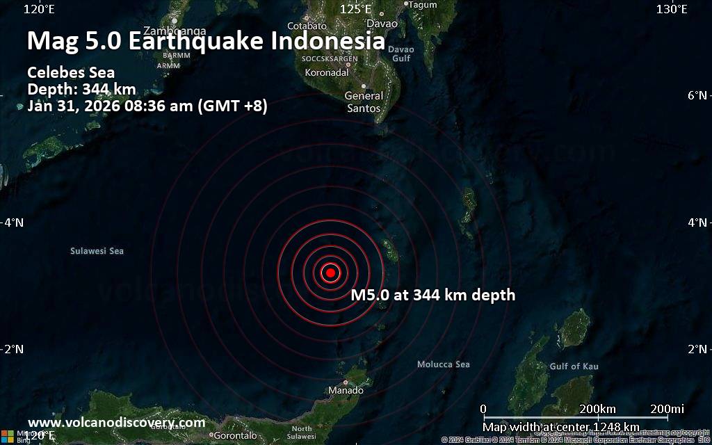 A very deep magnitude 5.0 earthquake was reported in the morning near Tahuna, Kabupaten Kepulauan Sangihe, Sulawesi Utara, Indonesia.
According to the European-Mediterranean Seismological Centre (EMSC), the quake hit on Saturday, January 31st, 2026, at 8:36 am local time at a great depth of 344. km. The strength of the earthquake may have been tempered by its relative great depth below the surface, which makes it feel weaker in absolute terms. The exact magnitude, epicenter, and depth of the quake might be revised within the next few hours or minutes as seismologists review data and refine their calculations, or as other agencies issue their report.
A second report was later issued by the Philippine Institute of Volcanology and Seismology (PHIVOLCS), which listed it as a magnitude 4.4 earthquake. Other agencies reporting the same quake include Indonesia's Meteorology, Climatology, and Geophysical Agency at magnitude 4.9, the German Research Centre for Geosciences (GFZ) at magnitude 4.9, and the citizen-seismograph network of RaspberryShake at magnitude 5.0.
Generally quakes of this magnitude are recorded by more than one agency and the results can vary, with subsequent reports that come in after the first one often showing more accuracy.
According to preliminary calculations, we do not expect that the quake was felt by many people and did not cause any damage. In Tahuna (pop. 35,300, 108 km away), the quake was probably not felt.
VolcanoDiscovery will automatically update magnitude and depth if these change and follow up if other significant news about the quake become available. If you’re in the area, please send us your experience through our reporting mechanism, either online or via our mobile app. This will help us provide more first-hand updates to anyone around the globe who wants to know more about this quake.
Earthquake data: Date & time: Jan 31, 2026 08:36 am (GMT +8) local time (31 Jan 2026 00:36 GMT)Magnitude: 5.0 Depth: 344.00 km Epicenter latitude / longitude: 3.21°N / 124.6°E  ( Indonesia) Primary data source: EMSChttps://www.volcanodiscovery.com/earthquake/news/293471/Magnitude-50-earthquake-strikes-near-Tahuna-Kabupaten-Kepulauan-Sangihe-Sulawesi-Utara-Indonesia.html
|
|


CMS The Best Conveyancing solicitors conveyancing quotes throughout the UK
For any webhosting enquiries please email webmaster@aus-city.com
|
|
Forums60
Topics783,598
Posts818,360
Members2,960
| |
Most Online22,463
May 9th, 2026
|
|
|
|
|
Copyright 1996 - 2026 by David Cottle. Designed by David Bate Jr. All Rights Reserved.
By using this forum, the user agrees not to transfer any data or technical information received under this agreement to any other entity without the express approval of the AUS-CITY Forum Admins and/or authors of individual posts (Forum Admins and DoD/USSPACECOM for the analysis of satellite tracking data).
Two-line elements (TLE) and all other satellite data presented and distributed via this forum and AUS-CITY mailing lists are distributed with permission from DoD/USSTRATCOM.

|

|


 - Click image for larger picture.")


