|
|
|
0 members (),
2,211
guests, and
25
robots. |
|
Key:
Admin,
Global Mod,
Mod
|
|
S |
M |
T |
W |
T |
F |
S |
|
1
|
2
|
3
|
4
|
5
|
6
|
7
|
|
8
|
9
|
10
|
11
|
12
|
13
|
14
|
|
15
|
16
|
17
|
18
|
19
|
20
|
21
|
|
22
|
23
|
24
|
25
|
26
|
27
|
28
|
|
There are no members with birthdays on this day. |
SPC MD 102
by Webmaster - Fri 20 Feb 2026 12:15:AM
|
SPC MD 103
by Webmaster - Fri 20 Feb 2026 12:15:AM
|
SPC MD 104
by Webmaster - Fri 20 Feb 2026 12:15:AM
|
|
|
|
|
|
|
|
|
|
|
|
|
|
|
|
|
Joined: Feb 2001
Posts: 381,904
Launch Director
|
OP

Launch Director
Joined: Feb 2001
Posts: 381,904 |
SPC Tornado Watch 10WW 10 TORNADO IL IN KY 191815Z - 200200Z 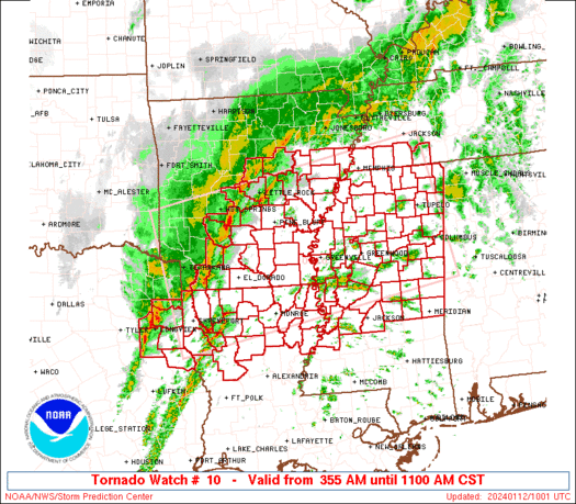
URGENT - IMMEDIATE BROADCAST REQUESTED
Tornado Watch Number 10
NWS Storm Prediction Center Norman OK
115 PM EST Thu Feb 19 2026

The NWS Storm Prediction Center has issued a

* Tornado Watch for portions of
  Southeast Illinois
  Southern Indiana
  Western and Central Kentucky

* Effective this Thursday afternoon and evening from 115 PM until
  900 PM EST.

* Primary threats include...
  A few tornadoes and a couple intense tornadoes possible
  Scattered large hail and isolated very large hail events to 2
    inches in diameter possible
  Scattered damaging wind gusts to 70 mph possible

SUMMARY...Thunderstorm development is anticipated this afternoon
from southeast Illinois into southern Indiana and western/central
Kentucky. In these areas, increasing low-level moisture will lead to
airmass destabilization. Strong vertical shear is in place,
supporting the potential for some of these storms to organize into
supercells. All severe hazards are possible with any supercells that
develop, including very large hail greater than 2" in diameter and
tornadoes. Low-level shear is strong enough to support the potential
for a strong (EF2+) tornado.

The tornado watch area is approximately along and 75 statute miles
north and south of a line from 50 miles west of Evansville IN to 50
miles east northeast of Louisville KY. For a complete depiction of
the watch see the associated watch outline update (WOUS64 KWNS
WOU0).

PRECAUTIONARY/PREPAREDNESS ACTIONS...

REMEMBER...A Tornado Watch means conditions are favorable for
tornadoes and severe thunderstorms in and close to the watch
area. Persons in these areas should be on the lookout for
threatening weather conditions and listen for later statements
and possible warnings.

&&

AVIATION...Tornadoes and a few severe thunderstorms with hail
surface and aloft to 2 inches. Extreme turbulence and surface wind
gusts to 60 knots. A few cumulonimbi with maximum tops to 500. Mean
storm motion vector 24035.

...Mosier
Read morehttps://www.spc.noaa.gov/products/watch/ww0010.html
|
|


CMS The Best Conveyancing solicitors conveyancing quotes throughout the UK
For any webhosting enquiries please email webmaster@aus-city.com
|
|
Forums60
Topics762,306
Posts797,036
Members2,957
| |
Most Online17,963
Jan 15th, 2026
|
|
|
|
|
Copyright 1996 - 2026 by David Cottle. Designed by David Bate Jr. All Rights Reserved.
By using this forum, the user agrees not to transfer any data or technical information received under the agreement, to any other entity without the express approval of the AUS-CITY Forum Admins and/or authors of individual posts (Forum Admins and DoD/USSPACECOM for the analysis of satellite tracking data).
Two-line elements (TLE) and all other satellite data presented and distributed via this forum and e-mail lists of AUS-CITY are distributed with permission from DoD/USSTRATCOM.

Reprise Hosting

|

|


 - Click image for larger picture.")


