|
|
|
0 members (),
1,618
guests, and
31
robots. |
|
Key:
Admin,
Global Mod,
Mod
|
|
S |
M |
T |
W |
T |
F |
S |
|
|
|
|
1
|
2
|
3
|
4
|
|
5
|
6
|
7
|
8
|
9
|
10
|
11
|
|
12
|
13
|
14
|
15
|
16
|
17
|
18
|
|
19
|
20
|
21
|
22
|
23
|
24
|
25
|
|
26
|
27
|
28
|
29
|
30
|
31
|
|
|
There are no members with birthdays on this day. |

Volcano earthquake report for Friday, 10 Jul 2026
• Moderate mag. 4.2 earthquake - 133 km northwest of Ternate, Kota Ternate, N...
• World Earthquake Report for Friday, 10 July 2026
• Moderate mag. 4.6 earthquake - 17 km southwest of Comalapa, Estado de Chiap...
• Moderate mag. 4.1 earthquake - Olyutorskiy Rayon, 47 km northwest of Tilich...
• Moderate mag. 4.0 earthquake - Hawke's Bay, New Zealand, on Saturday, Jul 1...
|

#801312
Fri 06 Mar 2026 10:50:PM
|
Joined: Feb 2001
Posts: 678,976
Launch Director
|
OP

Launch Director
Joined: Feb 2001
Posts: 678,976 |
Volcano earthquake report for Friday, 6 Mar 2026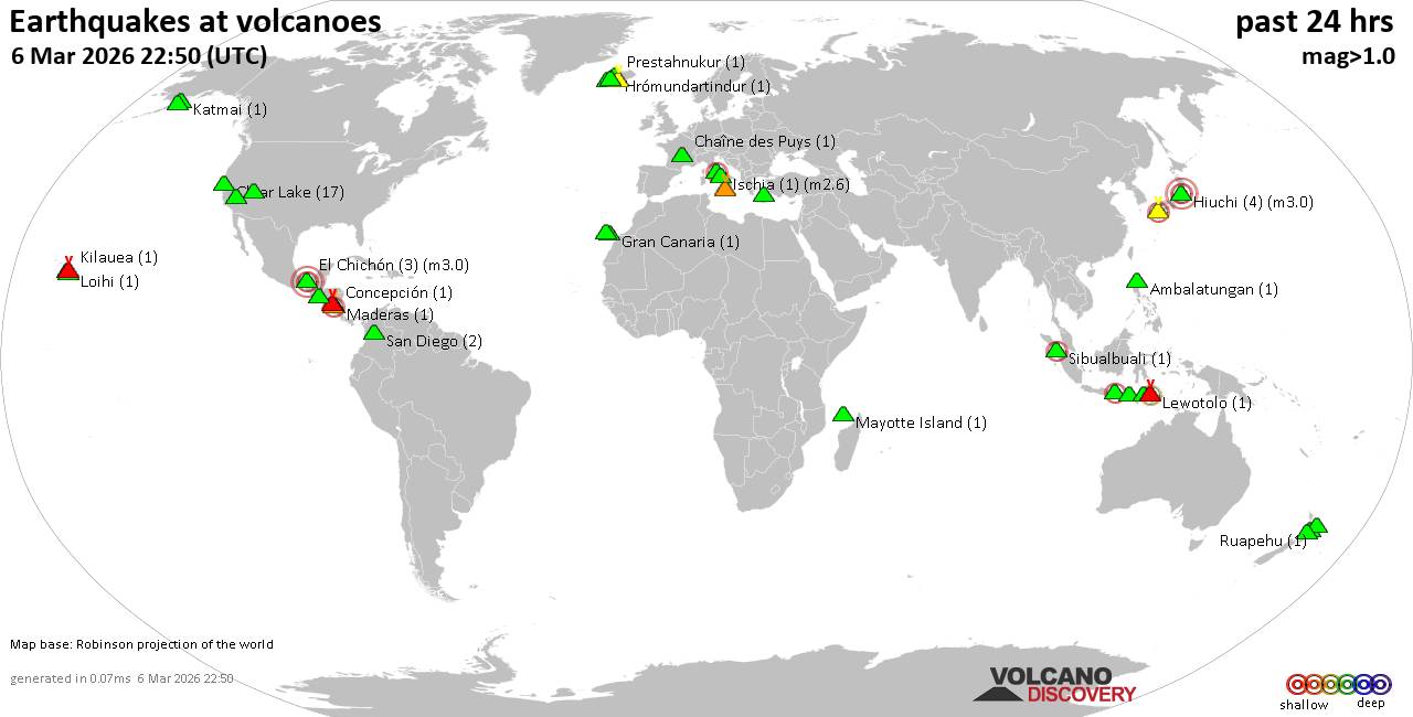 World map showing volcanoes with shallow (less than 50 km) earthquakes within 20 km radius during the past 24 hours on 6 Mar 2026 Number in brackets indicate nr of quakes. Quakes detected near: Ambalatungan (1 quake mag 1.6), Apaneca Range (8 quakes between mag 1.4-2.1), Aso (1 quake mag 2.8), Baluran (1 quake mag 2.6), Brennisteinsfjöll (3 quakes between mag 0.2-1.0), Chaîne des Puys (1 quake mag 1.3)
Clear Lake (17 quakes between mag 0.2-1.9), Colli Albani (3 quakes between mag 1.3-2.1), Concepción (1 quake mag 2.0), Coso (5 quakes between mag 0.8-1.4), El Chichón (3 quakes between mag 2.3-3.0), Eldey (3 quakes between mag 1.4-1.7), Etna (2 quakes between mag 0.9-1.1), Gran Canaria (1 quake mag 1.9), Hiuchi (4 quakes between mag 3.0-3.0), Hrómundartindur (1 quake mag 1.2), Ischia (1 quake mag 2.6), Katla (1 quake mag 1.4), Katmai (1 quake mag 1.0), Kilauea (1 quake mag 1.7), Kolumbo (1 quake mag 1.0), Lewotolo (1 quake mag 2.4), Loihi (1 quake mag 2.2), Maderas (1 quake mag 1.6), Masaya (2 quakes between mag 1.6-1.9), Maunaloa (1 quake mag 2.6), Mayotte Island (1 quake mag 1.0), Paluweh (1 quake mag 2.5), Prestahnukur (1 quake mag 1.4), Ruapehu (1 quake mag 1.2), San Diego (2 quakes between mag 0.9-1.2), Santa Clara (1 quake mag 1.4), Sibualbuali (1 quake mag 2.4), Tambora (1 quake mag 2.0), Taupo (1 quake mag 1.2), Tenerife (33 quakes between mag 0.3-1.8), Whale Island (1 quake mag 1.9) (updated 22h50)
Note: Earthquakes within 20 km from and at depths less than 50 km under active volcanoes are reported. The list is not complete because many volcanoes are not monitored and/or seismic data in high resolution is not available publicly.
Volcanoes with recent earthquakes above magnitude 2 or more than 10 quakes are listed below:
Apaneca Range volcano (El Salvador): 8 earthquakes up to magnitude 2.18 earthquakes occurred near (under) the volcano during 16 hours, the last being recorded quake 8 hours ago. Hypocenter depths ranged between 23.00 and 5.00 km. Earthquake details: (only 5 largest) 2.1 quake 18 km north of Sonsonate, Departamento de Sonsonate, El Salvador, Mar 6, 2026 09:01 am (GMT -6) (6 km E) 1.9 quake 19 km north of Sonsonate, Departamento de Sonsonate, El Salvador, Mar 6, 2026 09:04 am (GMT -6) (7 km E) 1.7 quake 18 km north of Sonsonate, Departamento de Sonsonate, El Salvador, Mar 5, 2026 04:52 pm (GMT -6) (6 km ESE) 1.6 quake 18 km north of Sonsonate, Departamento de Sonsonate, El Salvador, Mar 6, 2026 09:10 am (GMT -6) (4 km ESE) 1.6 quake 17 km north of Sonsonate, Departamento de Sonsonate, El Salvador, Mar 6, 2026 08:59 am (GMT -6) (6 km ESE) All earthquakes at Apaneca RangeAso volcano (Kyushu): magnitude 2.8 earthquakeA magnitude 2.8 earthquake occurred at the volcano 9 hours ago. The quake, which might be volcanic in origin, was located at a depth of 7.70 km depth at 11 km distance N from the volcano. Earthquake details: 2.8 quake 5.3 km north of Aso, Kumamoto, Japan, Mar 6, 2026 11:19 pm (GMT +9) (11 km N) All earthquakes at AsoBaluran volcano (East Java): magnitude 2.6 earthquakeA magnitude 2.6 earthquake occurred at the volcano 6 hours ago. The quake, which might be volcanic in origin, was located at a depth of 5.00 km depth at 2 km distance E from the volcano. Earthquake details: 2.6 quake Kabupaten Situbondo, 16 km north of Wongsorejo, Indonesia, Mar 6, 2026 11:22 pm (GMT +7) (2 km E) All earthquakes at BaluranClear Lake volcano (California): 17 earthquakes up to magnitude 1.9Possible earthquake swarm: 17 earthquakes occurred near (under) the volcano during 23 hours, the last being recorded quake 1 hour 15 minutes ago. Hypocenter depths ranged between 13.92 and 1.16 km. Earthquake details: (only 5 largest) 1.9 quake Sonoma County, 13 mi southwest of Clearlake, Lake County, California, United States, Mar 6, 2026 06:43 am (GMT -8) (16 km SSW) 1.8 quake Sonoma County, 13 mi southwest of Clearlake, Lake County, California, United States, Mar 6, 2026 06:44 am (GMT -8) (16 km SSW) 1.5 quake 27 mi north of Santa Rosa, Sonoma County, California, United States, Mar 6, 2026 05:20 am (GMT -8) (18 km SSW) 1.2 quake 27 mi north of Santa Rosa, Sonoma County, California, United States, Mar 6, 2026 12:10 pm (GMT -8) (16 km SSW) 1.2 quake 27 mi north of Santa Rosa, Sonoma County, California, United States, Mar 6, 2026 05:20 am (GMT -8) (18 km SSW) All earthquakes at Clear LakeColli Albani volcano (Italy): 3 earthquakes up to magnitude 2.13 earthquakes occurred near (under) the volcano during 8 minutes, the last being recorded quake 23 hours ago. Hypocenter depths ranged between 11.00 and 9.80 km. Earthquake details: 2.1 quake 8.7 km northeast of Velletri, Citta metropolitana di Roma Capitale, Lazio, Italy, Mar 6, 2026 12:23 am (GMT +1) (14 km ESE) 1.8 quake 7.7 km east of Velletri, Citta metropolitana di Roma Capitale, Lazio, Italy, Mar 6, 2026 12:16 am (GMT +1) (14 km ESE) 1.3 quake Provincia di Latina, 6.8 km east of Velletri, Italy, Mar 6, 2026 12:20 am (GMT +1) (13 km ESE) All earthquakes at Colli AlbaniEl Chichón volcano (Southern Mexico): 3 earthquakes up to magnitude 3.03 earthquakes occurred near (under) the volcano during 1 hour 20 minutes, the last being recorded quake 13 hours ago. Hypocenter depths ranged between 3.00 and 3.00 km. Earthquake details: 3.0 quake Estado de Chiapas, 37 km southwest of Teapa, Estado de Tabasco, Mexico, Mar 6, 2026 03:29 am (GMT -6) (0 km WNW) 2.3 quake Estado de Chiapas, 36 km southwest of Teapa, Estado de Tabasco, Mexico, Mar 6, 2026 02:09 am (GMT -6) (1 km NNW) 2.3 quake Estado de Chiapas, 36 km southwest of Teapa, Estado de Tabasco, Mexico, Mar 6, 2026 03:20 am (GMT -6) (1 km N) All earthquakes at El ChichónHiuchi volcano (Honshu): 4 earthquakes up to magnitude 3.04 earthquakes occurred near (under) the volcano during 13 hours, the last being recorded quake 8 hours ago. Hypocenter depths ranged between 10.00 and 10.00 km. Earthquake details: Unconfirmed earthquake or seismic-like event: Fukushima, 36 km southeast of Uonuma, Niigata, Japan, Mar 7, 2026 12:12 am (GMT +9) (10 km N) Unconfirmed earthquake or seismic-like event: Fukushima, 32 km northwest of Nikko, Tochigi, Japan, Mar 6, 2026 11:14 pm (GMT +9) (2 km E) Reported seismic-like event (likely no quake): 38 km northwest of Nikko, Tochigi, Japan, Mar 6, 2026 12:19 pm (GMT +9) (3 km NNE) Reported seismic-like event (likely no quake): 24 km south of Ichihara, Chiba, Japan, Mar 6, 2026 11:40 am (GMT +9) (9 km SSE) All earthquakes at HiuchiIschia volcano (Italy): magnitude 2.6 earthquakeA magnitude 2.6 earthquake occurred at the volcano 8 hours ago. The quake, which might be volcanic in origin, was located at a depth of 1.40 km depth at 1 km distance NE from the volcano. Earthquake details: 2.6 quake 3.3 km east of Forio, Napoli, Campania, Italy, Mar 6, 2026 03:26 pm (GMT +1) (1 km NE) All earthquakes at IschiaLewotolo volcano (Lesser Sunda Islands): magnitude 2.4 earthquakeA magnitude 2.4 earthquake occurred at the volcano 16 hours ago. The quake, which might be volcanic in origin, was located at a depth of 39.00 km depth at 14 km distance SW from the volcano. Earthquake details: 2.4 quake 1.3 km east of Lewoleba, Kabupaten Lembata, East Nusa Tenggara, Indonesia, Mar 6, 2026 02:23 pm (GMT +8) (14 km SW) All earthquakes at LewotoloLoihi volcano (Hawai'i (Big Island)): magnitude 2.2 earthquakeA magnitude 2.2 earthquake occurred at the volcano 23 hours ago. The quake, which might be volcanic in origin, was located at a depth of 35.98 km depth at 16 km distance NW from the volcano. Earthquake details: 2.2 quake North Pacific Ocean, 41 mi southeast of of Hawai‘i Island, Hawaii County, Hawaii, United States, Mar 5, 2026 01:21 pm (GMT -10) (16 km NW) All earthquakes at LoihiMaunaloa volcano (Hawai'i (Big Island)): magnitude 2.6 earthquakeA magnitude 2.6 earthquake occurred at the volcano 21 hours ago. The quake, which might be volcanic in origin, was located at a depth of 1.52 km depth at 6 km distance S from the volcano. Earthquake details: 2.6 quake 40 mi southwest of Hilo, Hawaii County, Hawaii, United States, Mar 5, 2026 03:27 pm (GMT -10) (6 km S) All earthquakes at MaunaloaPaluweh volcano (Lesser Sunda Islands): magnitude 2.5 earthquakeA magnitude 2.5 earthquake occurred at the volcano 16 hours ago. The quake, which might be volcanic in origin, was located at a depth of 10.00 km depth at 17 km distance W from the volcano. Earthquake details: 2.5 quake Flores Sea, 61 km north of Ende, Kabupaten Ende, East Nusa Tenggara, Indonesia, Mar 6, 2026 02:35 pm (GMT +8) (17 km W) All earthquakes at PaluwehSibualbuali volcano (Sumatra): magnitude 2.4 earthquakeA magnitude 2.4 earthquake occurred at the volcano 10 hours ago. The quake, which might be volcanic in origin, was located at a depth of 3.00 km depth at 18 km distance NNW from the volcano. Earthquake details: 2.4 quake Kabupaten Tapanuli Utara, 36 km north of Padangsidempuan, Indonesia, Mar 6, 2026 08:07 pm (GMT +7) (18 km NNW) All earthquakes at SibualbualiTenerife volcano (Canary Islands): 33 earthquakes up to magnitude 1.8Possible earthquake swarm: 33 earthquakes occurred near (under) the volcano during 16 hours, the last being recorded quake 6 hours ago. Hypocenter depths ranged between 27.30 and 4.00 km. Earthquake details: (only 5 largest) 1.8 quake 6.8 km northeast of Guia de Isora, Santa Cruz de Tenerife, Canary Islands, Spain, Mar 6, 2026 07:59 am (Universal Time) (11 km W) 1.5 quake 16 km north of Arona, Santa Cruz de Tenerife, Canary Islands, Spain, Mar 6, 2026 05:07 pm (Universal Time) (4 km SSW) 1.4 quake 13 km north of Arona, Santa Cruz de Tenerife, Canary Islands, Spain, Mar 6, 2026 11:00 am (Universal Time) (8 km SSW) 1.4 quake 13 km south of Realejo Alto, Santa Cruz de Tenerife, Canary Islands, Spain, Mar 6, 2026 10:44 am (Universal Time) (5 km ESE) 1.4 quake 14 km north of Adeje, Santa Cruz de Tenerife, Canary Islands, Spain, Mar 6, 2026 02:29 am (Universal Time) (5 km SW) All earthquakes at Tenerifehttps://www.volcanodiscovery.com/earthquakes-volcanoes/news/296776/Volcano-earthquake-report-for-Friday-6-Mar-2026.html
|
|


CMS The Best Conveyancing solicitors conveyancing quotes throughout the UK
For any webhosting enquiries please email webmaster@aus-city.com
|
|
Forums60
Topics787,740
Posts822,514
Members2,960
| |
Most Online102,106
Jul 10th, 2026
|
|
|
|
|
Copyright 1996 - 2026 by David Cottle. Designed by David Bate Jr. All Rights Reserved.
By using this forum, the user agrees not to transfer any data or technical information received under this agreement to any other entity without the express approval of the AUS-CITY Forum Admins and/or authors of individual posts (Forum Admins and DoD/USSPACECOM for the analysis of satellite tracking data).
Two-line elements (TLE) and all other satellite data presented and distributed via this forum and AUS-CITY mailing lists are distributed with permission from DoD/USSTRATCOM.

|

|


 - Click image for larger picture.")


