|
|
|
0 members (),
1,095
guests, and
21
robots. |
|
Key:
Admin,
Global Mod,
Mod
|
|
S |
M |
T |
W |
T |
F |
S |
|
1
|
2
|
3
|
4
|
5
|
6
|
7
|
|
8
|
9
|
10
|
11
|
12
|
13
|
14
|
|
15
|
16
|
17
|
18
|
19
|
20
|
21
|
|
22
|
23
|
24
|
25
|
26
|
27
|
28
|
|
29
|
30
|
31
|
|
|
|
|
|
There are no members with birthdays on this day. |
|
|
Joined: Feb 2001
Posts: 381,904
Launch Director
|
OP

Launch Director
Joined: Feb 2001
Posts: 381,904 |
Moderate magnitude 4.2 quake hits 45 miles southwest of Hilo, Hawaii, United States in the afternoon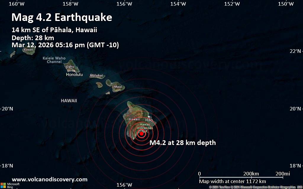 A shallow magnitude 4.2 earthquake was reported in the afternoon near Hilo, Hawaii County, Hawaii, USA.
According to the United States Geological Survey, the quake hit on Thursday, March 12th, 2026, at 5:16 pm local time at a shallow depth of 18 miles. Shallow earthquakes are felt more strongly than deeper ones as they are closer to the surface. The exact magnitude, epicenter, and depth of the quake might be revised within the next few hours or minutes as seismologists review data and refine their calculations, or as other agencies issue their report.
Based on the preliminary seismic data, the quake should not have caused any significant damage, but was probably felt by many people as light vibration in the area of the epicenter.
Weak shaking might have been felt in Pāhala (pop. 1,400) located 9 miles from the epicenter, and Discovery Harbor (pop. 1,200) 18 miles away.
Other towns or cities near the epicenter where the quake might have been felt as very weak shaking include Volcano (pop. 2,600) located 24 miles from the epicenter, Hawaiian Ocean View (pop. 4,400) 26 miles away, Fern Forest (pop. 1,200) 28 miles away, Eden Roc (pop. 1,400) 31 miles away, Mountain View (pop. 3,900) 34 miles away, Hawaiian Paradise Park (pop. 11,400) 41 miles away, and Hilo (pop. 43,300) 45 miles away.
Earthquake data: Date & time: Mar 13, 2026 03:16 am (Universal Time) local time (13 Mar 2026 03:16 GMT)Magnitude: 4.2 Depth: 31.30 km Epicenter latitude / longitude: 19.13°N / 155.37°W  (Hawaii, Hawaii, United States) Primary data source: USGShttps://www.volcanodiscovery.com/earthquake/news/297488/Moderate-magnitude-42-quake-hits-45-miles-southwest-of-Hilo-Hawaii-United-States-in-the-afternoon-.html
|
|


CMS The Best Conveyancing solicitors conveyancing quotes throughout the UK
For any webhosting enquiries please email webmaster@aus-city.com
|
|
Forums60
Topics765,641
Posts800,393
Members2,958
| |
Most Online17,963
Jan 15th, 2026
|
|
|
|
|
Copyright 1996 - 2026 by David Cottle. Designed by David Bate Jr. All Rights Reserved.
By using this forum, the user agrees not to transfer any data or technical information received under the agreement, to any other entity without the express approval of the AUS-CITY Forum Admins and/or authors of individual posts (Forum Admins and DoD/USSPACECOM for the analysis of satellite tracking data).
Two-line elements (TLE) and all other satellite data presented and distributed via this forum and e-mail lists of AUS-CITY are distributed with permission from DoD/USSTRATCOM.

Reprise Hosting

|

|


 - Click image for larger picture.")


