|
|
|
0 members (),
1,746
guests, and
31
robots. |
|
Key:
Admin,
Global Mod,
Mod
|
|
S |
M |
T |
W |
T |
F |
S |
|
|
|
|
1
|
2
|
3
|
4
|
|
5
|
6
|
7
|
8
|
9
|
10
|
11
|
|
12
|
13
|
14
|
15
|
16
|
17
|
18
|
|
19
|
20
|
21
|
22
|
23
|
24
|
25
|
|
26
|
27
|
28
|
29
|
30
|
31
|
|
|
There are no members with birthdays on this day. |

Volcano earthquake report for Friday, 10 Jul 2026
• Moderate mag. 4.2 earthquake - 133 km northwest of Ternate, Kota Ternate, N...
• World Earthquake Report for Friday, 10 July 2026
• Moderate mag. 4.6 earthquake - 17 km southwest of Comalapa, Estado de Chiap...
• Moderate mag. 4.1 earthquake - Olyutorskiy Rayon, 47 km northwest of Tilich...
• Moderate mag. 4.0 earthquake - Hawke's Bay, New Zealand, on Saturday, Jul 1...
|

#804531
Mon 06 Apr 2026 01:50:PM
|
Joined: Feb 2001
Posts: 678,976
Launch Director
|
OP

Launch Director
Joined: Feb 2001
Posts: 678,976 |
Volcano earthquake report for Monday, 6 Apr 2026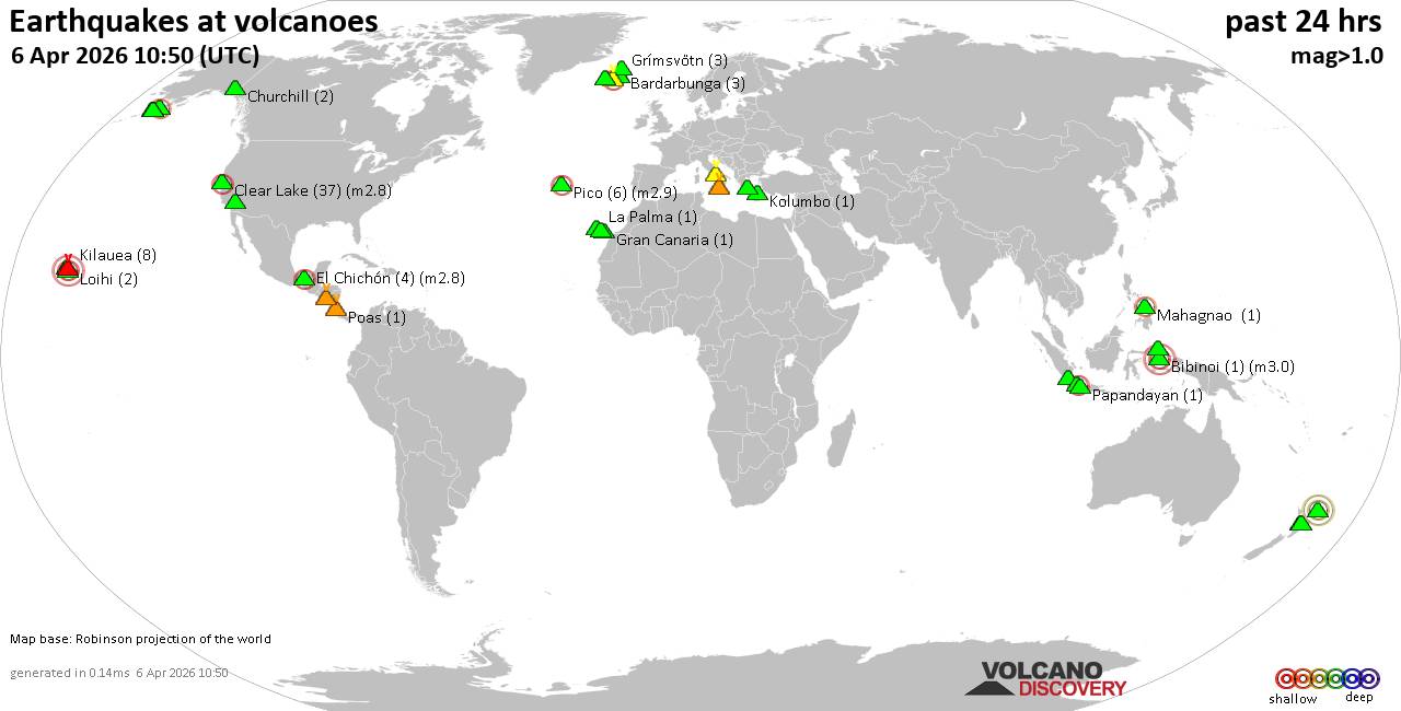 World map showing volcanoes with shallow (less than 50 km) earthquakes within 20 km radius during the past 24 hours on 6 Apr 2026 Number in brackets indicate nr of quakes. Quakes detected near: Bardarbunga (5 quakes between mag 0.0-1.1), Bibinoi (1 quake mag 3.0), Black Peak (1 quake mag 2.0), Brennisteinsfjöll (2 quakes between mag 0.0-1.2), Campi Flegrei (Phlegrean Fields) (10 quakes between mag 0.1-2.1), Churchill (2 quakes between mag 1.1-1.2)
Clear Lake (37 quakes between mag 0.2-2.8), El Chichón (2 quakes between mag 2.1-2.2), Gede-Pangrango (1 quake mag 2.1), Grímsvötn (3 quakes between mag 0.5-1.2), Hualalai (1 quake mag 3.9), Katla (11 quakes between mag 0.1-2.1), Kilauea (6 quakes between mag 1.7-1.8), Kolumbo (2 quakes between mag 1.3-1.9), Kupreanof (1 quake mag 1.1), La Palma (1 quake mag 1.6), Lavic Lake (1 quake mag 1.4), Loihi (2 quakes between mag 1.7-1.7), Mahagnao (1 quake mag 2.1), Maroa (2 quakes between mag 1.3-1.9), Papandayan (1 quake mag 2.0), Parker (1 quake mag 1.7), Poas (1 quake mag 1.7), San Cristobal (1 quake mag 1.8), Sousaki (1 quake mag 1.6), Stepovak Bay 2 (1 quake mag 1.3), Stepovak Bay 4 (1 quake mag 1.9), Tenerife (12 quakes between mag 0.4-1.4), Tjörnes Fracture Zone (5 quakes between mag 0.3-1.0), Todoko-Ranu (1 quake mag 2.2), Turrialba (1 quake mag 1.4) (updated 13h50)
Note: Earthquakes within 20 km from and at depths less than 50 km under active volcanoes are reported. The list is not complete because many volcanoes are not monitored and/or seismic data in high resolution is not available publicly.
Volcanoes with recent earthquakes above magnitude 2 or more than 10 quakes are listed below:
Bibinoi volcano (Halmahera): magnitude 3.0 earthquakeA magnitude 3.0 earthquake occurred at the volcano 3 hours ago. The quake, which might be volcanic in origin, was located at a depth of 9.00 km depth at 19 km distance SSW from the volcano. Earthquake details: 3.0 quake Maluku Sea, 42 km southeast of Labuha, Indonesia, Apr 6, 2026 07:23 pm (GMT +9) (19 km SSW) All earthquakes at BibinoiCampi Flegrei (Phlegrean Fields) volcano (Italy): 10 earthquakes up to magnitude 2.110 earthquakes occurred near (under) the volcano during 16 hours, the last being recorded quake 7 hours ago. Hypocenter depths ranged between 8.25 and 0.25 km. Earthquake details: (only 5 largest) 2.1 quake 5 km southeast of Pozzuoli, Napoli, Campania, Italy, Apr 5, 2026 04:33 pm (GMT +2) (1 km SSE) 1.8 quake 4.6 km west of Fuorigrotta, Napoli, Campania, Italy, Apr 6, 2026 04:51 am (GMT +2) (1 km SE) 1.7 quake 5 km southeast of Pozzuoli, Napoli, Campania, Italy, Apr 5, 2026 04:34 pm (GMT +2) (1 km SE) 1.5 quake 4.5 km southeast of Pozzuoli, Napoli, Campania, Italy, Apr 6, 2026 04:52 am (GMT +2) (1 km S) 0.1 quake 3.1 km south of Pianura, Napoli, Campania, Italy, Apr 6, 2026 08:47 am (GMT +2) (2 km ENE) All earthquakes at Campi Flegrei (Phlegrean Fields)Clear Lake volcano (California): 37 earthquakes up to magnitude 2.8Possible earthquake swarm: 37 earthquakes occurred near (under) the volcano during 21 hours, the last being recorded quake 2 hours ago. Hypocenter depths ranged between 19.51 and 0.46 km. Earthquake details: (only 5 largest) 2.8 quake 25 mi north of Santa Rosa, Sonoma County, California, United States, Apr 5, 2026 10:48 am (GMT -7) (19 km S) 1.5 quake 12 mi southwest of Clearlake, Lake County, California, United States, Apr 6, 2026 12:48 am (GMT -7) (15 km S) 1.4 quake 27 mi north of Santa Rosa, Sonoma County, California, United States, Apr 6, 2026 04:40 am (GMT -7) (16 km S) 1.3 quake 27 mi north of Santa Rosa, Sonoma County, California, United States, Apr 5, 2026 09:27 pm (GMT -7) (18 km SSW) 1.3 quake 27 mi north of Santa Rosa, Sonoma County, California, United States, Apr 5, 2026 07:18 am (GMT -7) (16 km S) All earthquakes at Clear LakeEl Chichón volcano (Southern Mexico): 2 earthquakes up to magnitude 2.22 earthquakes occurred near (under) the volcano during 51 minutes, the last being recorded quake 17 hours ago. Hypocenter depths ranged between 3.00 and 3.00 km. Earthquake details: 2.2 quake Estado de Chiapas, 37 km southwest of Teapa, Estado de Tabasco, Mexico, Apr 5, 2026 01:37 pm (GMT -6) (1 km NNW) 2.1 quake Estado de Chiapas, 36 km southwest of Teapa, Estado de Tabasco, Mexico, Apr 5, 2026 02:28 pm (GMT -6) (1 km NNW) All earthquakes at El ChichónGede-Pangrango volcano (West Java): magnitude 2.1 earthquakeA magnitude 2.1 earthquake occurred at the volcano 4 hours ago. The quake, which might be volcanic in origin, was located at a depth of 6.00 km depth at 15 km distance E from the volcano. Earthquake details: 2.1 quake 5.1 km northwest of Cianjur, Kabupaten Cianjur, Jawa Barat, Indonesia, Apr 6, 2026 04:30 pm (GMT +7) (15 km E) All earthquakes at Gede-PangrangoHualalai volcano (Hawai'i (Big Island)): magnitude 3.9 earthquakeA magnitude 3.9 earthquake occurred at the volcano 16 hours ago. The quake, which might be volcanic in origin, was located at a depth of 2.42 km depth at 18 km distance SE from the volcano. Earthquake details: 3.9 quake 47 mi southeast of Kailua-Kona, Hawaii County, Hawaii, United States, Apr 5, 2026 11:41 am (Honolulu time) (18 km SE) All earthquakes at HualalaiKatla volcano (Iceland): 11 earthquakes up to magnitude 2.1Possible earthquake swarm: 11 earthquakes occurred near (under) the volcano during 9 hours, the last being recorded quake 12 hours ago. Hypocenter depths ranged between 5.20 and 0.00 km. Earthquake details: (only 5 largest) 2.1 quake 2.2 km ESE of Goðabunga Apr 5, 2026 11:21 pm (Universal Time) (8 km W) 1.9 quake 2.1 km ESE of Goðabunga Apr 5, 2026 05:24 pm (Universal Time) (8 km W) 1.4 quake 2.2 km SE of Goðabunga Apr 5, 2026 11:33 pm (Universal Time) (8 km W) 1.0 quake 3.6 km E of Goðabunga Apr 5, 2026 11:38 pm (Universal Time) (6 km WNW) 1.0 quake Iceland: 7.3 km N of Hábunga Apr 5, 2026 06:46 pm (Reykjavik time) (3 km NW) All earthquakes at KatlaMahagnao volcano (Central Philippines): magnitude 2.1 earthquakeA magnitude 2.1 earthquake occurred at the volcano 7 hours ago. The quake, which might be volcanic in origin, was located at a depth of 24.00 km depth at 13 km distance N from the volcano. Earthquake details: 2.1 quake 5.2 km northwest of Burauen, Province of Leyte, Eastern Visayas, Philippines, Apr 6, 2026 03:03 pm (GMT +8) (13 km N) All earthquakes at Mahagnao Tenerife volcano (Canary Islands): 12 earthquakes up to magnitude 1.4Possible earthquake swarm: 12 earthquakes occurred near (under) the volcano during 13 hours, the last being recorded quake 10 hours ago. Hypocenter depths ranged between 18.00 and 9.00 km. Earthquake details: (only 5 largest) 1.4 quake 13 km north of Adeje, Santa Cruz de Tenerife, Canary Islands, Spain, Apr 5, 2026 03:31 pm (GMT +1) (5 km SW) 1.3 quake 4.6 km northwest of Granadilla de Abona, Spain, Apr 5, 2026 10:56 pm (GMT +1) (14 km SSE) 1.3 quake 15 km north of Arona, Santa Cruz de Tenerife, Canary Islands, Spain, Apr 5, 2026 09:25 pm (GMT +1) (5 km SSW) 1.2 quake 17 km north of Arona, Santa Cruz de Tenerife, Canary Islands, Spain, Apr 5, 2026 09:10 pm (GMT +1) (4 km WSW) 1.2 quake 15 km north of Arona, Santa Cruz de Tenerife, Canary Islands, Spain, Apr 5, 2026 08:59 pm (GMT +1) (6 km SW) All earthquakes at TenerifeTodoko-Ranu volcano (Halmahera): magnitude 2.2 earthquakeA magnitude 2.2 earthquake occurred at the volcano 23 hours ago. The quake, which might be volcanic in origin, was located at a depth of 7.00 km depth at 6 km distance N from the volcano. Earthquake details: 2.2 quake Kabupaten Halmahera Barat, 57 km north of Ternate, Indonesia, Apr 5, 2026 11:28 pm (GMT +9) (6 km N) All earthquakes at Todoko-Ranu https://www.volcanodiscovery.com/earthquakes-volcanoes/news/299350/Volcano-earthquake-report-for-Monday-6-Apr-2026.html
|
|


CMS The Best Conveyancing solicitors conveyancing quotes throughout the UK
For any webhosting enquiries please email webmaster@aus-city.com
|
|
Forums60
Topics787,680
Posts822,454
Members2,960
| |
Most Online102,106
Yesterday at 06:57 PM
|
|
|
|
|
Copyright 1996 - 2026 by David Cottle. Designed by David Bate Jr. All Rights Reserved.
By using this forum, the user agrees not to transfer any data or technical information received under this agreement to any other entity without the express approval of the AUS-CITY Forum Admins and/or authors of individual posts (Forum Admins and DoD/USSPACECOM for the analysis of satellite tracking data).
Two-line elements (TLE) and all other satellite data presented and distributed via this forum and AUS-CITY mailing lists are distributed with permission from DoD/USSTRATCOM.

|

|


 - Click image for larger picture.")


