|
|
|
0 members (),
2,855
guests, and
24
robots. |
|
Key:
Admin,
Global Mod,
Mod
|
|
S |
M |
T |
W |
T |
F |
S |
|
|
|
|
1
|
2
|
3
|
4
|
|
5
|
6
|
7
|
8
|
9
|
10
|
11
|
|
12
|
13
|
14
|
15
|
16
|
17
|
18
|
|
19
|
20
|
21
|
22
|
23
|
24
|
25
|
|
26
|
27
|
28
|
29
|
30
|
|
|
|
There are no members with birthdays on this day. |
|
|
Joined: Feb 2001
Posts: 381,904
Launch Director
|
OP

Launch Director
Joined: Feb 2001
Posts: 381,904 |
Moderate magnitude 4.6 earthquake 114 km north of Daruba, Indonesia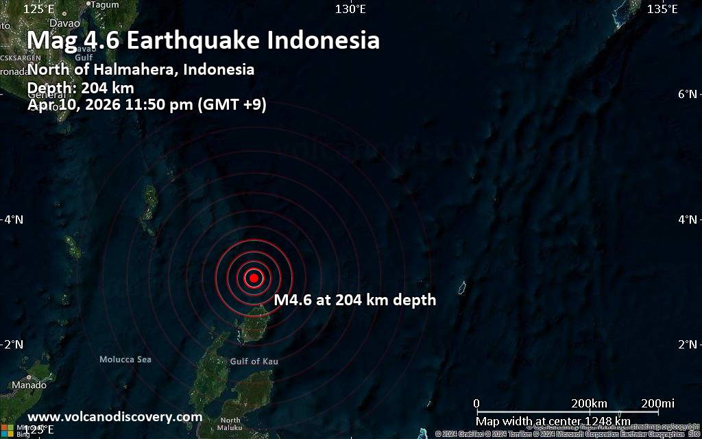 Indonesia's Meteorology, Climatology, and Geophysical Agency reported a magnitude 4.6 quake in Indonesia near Daruba, Morotai Island Regency, North Maluku, only 18 minutes ago. The earthquake hit late at night on Friday, April 10th, 2026, at 11:50 pm local time at an intermediate to considerable depth of 204. km. The exact magnitude, epicenter, and depth of the quake might be revised within the next few hours or minutes as seismologists review data and refine their calculations, or as other agencies issue their report.
Our monitoring service identified a second report from the European-Mediterranean Seismological Centre (EMSC) which listed the quake at magnitude 3.8. A third agency, the citizen-seismograph network of RaspberryShake, reported the same quake at magnitude 4.6.
According to preliminary calculations, we do not expect that the quake was felt by many people and did not cause any damage. In Daruba (pop. 23,600, 114 km away), the quake was probably not felt.
VolcanoDiscovery will automatically update magnitude and depth if these change and follow up if other significant news about the quake become available. If you’re in the area, please send us your experience through our reporting mechanism, either online or via our mobile app. This will help us provide more first-hand updates to anyone around the globe who wants to know more about this quake.
Earthquake data: Date & time: Apr 10, 2026 11:50 pm (GMT +9) local time (10 Apr 2026 14:50 GMT)Magnitude: 4.6 Depth: 204.00 km Epicenter latitude / longitude: 3.06°N / 128.45°E  ( North Maluku, Indonesia) Primary data source: BMKGhttps://www.volcanodiscovery.com/earthquake/news/299683/Moderate-magnitude-46-earthquake-114-km-north-of-Daruba-Indonesia.html
|
|


CMS The Best Conveyancing solicitors conveyancing quotes throughout the UK
For any webhosting enquiries please email webmaster@aus-city.com
|
|
Forums60
Topics768,733
Posts803,498
Members2,958
| |
Most Online17,963
Jan 15th, 2026
|
|
|
|
|
Copyright 1996 - 2026 by David Cottle. Designed by David Bate Jr. All Rights Reserved.
By using this forum, the user agrees not to transfer any data or technical information received under the agreement, to any other entity without the express approval of the AUS-CITY Forum Admins and/or authors of individual posts (Forum Admins and DoD/USSPACECOM for the analysis of satellite tracking data).
Two-line elements (TLE) and all other satellite data presented and distributed via this forum and e-mail lists of AUS-CITY are distributed with permission from DoD/USSTRATCOM.

Reprise Hosting

|

|


 - Click image for larger picture.")


