|
0 members (),
1,551
guests, and
101
robots. |
|
Key:
Admin,
Global Mod,
Mod
|
|
S |
M |
T |
W |
T |
F |
S |
|
|
|
|
1
|
2
|
3
|
4
|
|
5
|
6
|
7
|
8
|
9
|
10
|
11
|
|
12
|
13
|
14
|
15
|
16
|
17
|
18
|
|
19
|
20
|
21
|
22
|
23
|
24
|
25
|
|
26
|
27
|
28
|
29
|
30
|
31
|
|
|
There are no members with birthdays on this day. |

Volcano earthquake report for Friday, 3 Jul 2026
• World Earthquake Report for Friday, 3 July 2026
• Light mag. 3.9 earthquake - South Pacific Ocean, 14 km southwest of Huasco,...
• Significant magnitude 5.5 earthquake 38 km northwest of Valparaiso, Chile
• Strong mag. 5.5 earthquake - South Pacific Ocean, 38 km north of Valparaiso...
• Strong mag. 5.3 earthquake - Balleny Islands Region on Saturday, Jul 4, 202...
|

#805287
Fri 10 Apr 2026 09:52:PM
|
Joined: Feb 2001
Posts: 678,976
Launch Director
|
OP

Launch Director
Joined: Feb 2001
Posts: 678,976 |
SPC MD 376MD 0376 CONCERNING SEVERE POTENTIAL...WATCH UNLIKELY FOR EASTERN NEW MEXICO INTO THE TEXAS/OKLAHOMA PANHANDLES 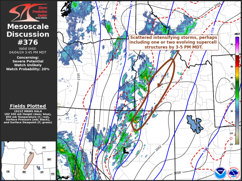
Mesoscale Discussion 0376
NWS Storm Prediction Center Norman OK
0451 PM CDT Fri Apr 10 2026

Areas affected...Eastern New Mexico into the Texas/Oklahoma
Panhandles

Concerning...Severe potential...Watch unlikely

Valid 102151Z - 102345Z

Probability of Watch Issuance...20 percent

SUMMARY...Marginally severe thunderstorms across portions of eastern
New Mexico into the Texas and Oklahoma Panhandles will persist late
this afternoon into the evening hours. These storms will primarily
be capable of damaging wind gusts and 1.00-1.25 inch hail. No
weather watch issuance is anticipated at this time.

DISCUSSION...Thunderstorms have developed in the vicinity and south
of a surface cold front currently oriented east-west across portions
of the Oklahoma and Texas Panhandles. Storms along and immediately
south of the boundary will have support for at least some convective
organization due to modest deep-layer shear of 35-40 kts, while
further to the south and into eastern New Mexico, storms have
primarily developed in deep/dry boundary layers with steep low-level
lapse rates. All storms will be capable of some severe wind gusts
and 1.00-1.25 in hail, with the greatest threat for organized severe
storms being along and immediately south of the surface cold front.
Thunderstorms in the deep/dry boundary layers further south are more
likely to remain disorganized, but are capable of downbursts owing
to the steep low-level lapse rates and tall LCL heights in excess of
2 km. No WW issuance is anticipated at this time.

..Halbert/Thompson.. 04/10/2026

...Please see www.spc.noaa.gov for graphic product...

ATTN...WFO...LUB...AMA...MAF...ABQ...EPZ...

LAT...LON   35130532 35530527 36070488 36450336 36650154 36560058
            36370020 35860023 35340101 34520268 33970339 33270399
            32970463 32940513 33290552 33700550 34060547 35130532

MOST PROBABLE PEAK WIND GUST...UP TO 60 MPH
MOST PROBABLE PEAK HAIL SIZE...UP TO 1.25 IN
Read morehttps://www.spc.noaa.gov/products/md/md0376.html
|
|


CMS The Best Conveyancing solicitors conveyancing quotes throughout the UK
For any webhosting enquiries please email webmaster@aus-city.com
|
|
Forums60
Topics786,727
Posts821,499
Members2,960
| |
Most Online22,463
May 9th, 2026
|
|
|


 - Click image for larger picture.")


