|
|
|
0 members (),
2,282
guests, and
24
robots. |
|
Key:
Admin,
Global Mod,
Mod
|
|
S |
M |
T |
W |
T |
F |
S |
|
|
|
|
1
|
2
|
3
|
4
|
|
5
|
6
|
7
|
8
|
9
|
10
|
11
|
|
12
|
13
|
14
|
15
|
16
|
17
|
18
|
|
19
|
20
|
21
|
22
|
23
|
24
|
25
|
|
26
|
27
|
28
|
29
|
30
|
|
|
|
There are no members with birthdays on this day. |
|
|
Joined: Feb 2001
Posts: 381,904
Launch Director
|
OP

Launch Director
Joined: Feb 2001
Posts: 381,904 |
Volcano earthquake report for Saturday, 11 Apr 2026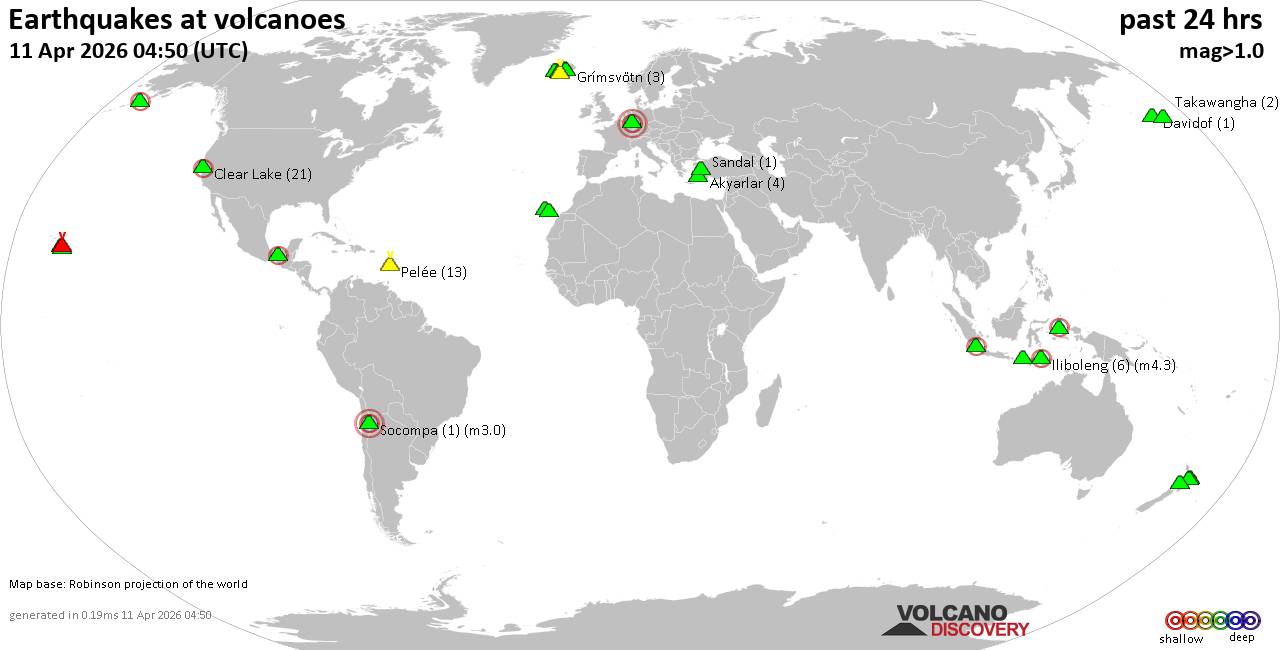 World map showing volcanoes with shallow (less than 50 km) earthquakes within 20 km radius during the past 24 hours on 11 Apr 2026 Number in brackets indicate nr of quakes. Quakes detected near: Bardarbunga (8 quakes between mag 0.5-1.7), Barva (2 quakes between mag 1.9-2.4), Clear Lake (13 quakes between mag 0.7-2.1), Coso (4 quakes between mag 0.3-1.3), El Chichón (3 quakes between mag 2.7-2.9), Etna (2 quakes between mag 1.1-1.2)
Grímsnes (6 quakes between mag 0.1-1.2), Hekla (1 quake mag 1.0), Iliboleng (10 quakes between mag 2.1-2.9), Isla San Luis (2 quakes between mag 3.7-4.0), Jailolo (1 quake mag 2.2), Katla (8 quakes between mag 0.1-1.6), Katmai (1 quake mag 1.7), Kilauea (5 quakes between mag 1.7-2.6), Krísuvík (5 quakes between mag 0.0-1.4), Latukan (2 quakes between mag 1.6-2.2), Loihi (2 quakes between mag 1.9-1.9), Mammoth Mountain (1 quake mag 1.3), Maroa (5 quakes between mag 1.6-2.4), Maunaloa (1 quake mag 2.2), Ndete Napu (1 quake mag 2.7), Nisyros (1 quake mag 2.0), Piton de la Fournaise (7 quakes between mag 0.3-1.8), Reporoa (1 quake mag 1.5), Sanbe (1 quake mag 4.0), Svartsengi (3 quakes between mag 0.5-1.0), Tambora (1 quake mag 2.2), Taupo (1 quake mag 1.9), Tenerife (12 quakes between mag 1.0-2.0), Tjörnes Fracture Zone (4 quakes between mag 0.2-1.3), Torfajökull (7 quakes between mag 0.1-1.0) (updated 23h50)
Note: Earthquakes within 20 km from and at depths less than 50 km under active volcanoes are reported. The list is not complete because many volcanoes are not monitored and/or seismic data in high resolution is not available publicly.
Volcanoes with recent earthquakes above magnitude 2 or more than 10 quakes are listed below:
Barva volcano (Costa Rica): 2 earthquakes up to magnitude 2.42 earthquakes occurred near (under) the volcano during 36 minutes, the last being recorded quake 6 hours ago. Hypocenter depths ranged between 18.00 and 13.00 km. Earthquake details: 2.4 quake Provincia de Heredia, 27 km northeast of San Jose, Costa Rica, Apr 11, 2026 11:42 am (Costa_Rica time) (13 km E) 1.9 quake Provincia de Heredia, 30 km northeast of San Jose, Costa Rica, Apr 11, 2026 12:18 pm (Costa_Rica time) (16 km ENE) All earthquakes at BarvaClear Lake volcano (California): 13 earthquakes up to magnitude 2.1Possible earthquake swarm: 13 earthquakes occurred near (under) the volcano during 23 hours, the last being recorded quake 39 minutes ago. Hypocenter depths ranged between 3.82 and 0.33 km. Earthquake details: (only 5 largest) 2.1 quake Sonoma County, 13 mi southwest of Clearlake, Lake County, California, United States, Apr 11, 2026 12:54 am (GMT -7) (16 km SSW) 1.6 quake Sonoma County, 13 mi southwest of Clearlake, Lake County, California, United States, Apr 11, 2026 11:53 am (GMT -7) (19 km S) 1.5 quake 27 mi north of Santa Rosa, Sonoma County, California, United States, Apr 10, 2026 08:43 pm (GMT -7) (17 km S) 1.3 quake 25 mi north of Santa Rosa, Sonoma County, California, United States, Apr 11, 2026 04:10 pm (GMT -7) (19 km S) 1.2 quake 25 mi north of Santa Rosa, Sonoma County, California, United States, Apr 11, 2026 11:55 am (GMT -7) (19 km S) All earthquakes at Clear LakeEl Chichón volcano (Southern Mexico): 3 earthquakes up to magnitude 2.93 earthquakes occurred near (under) the volcano during 6 hours, the last being recorded quake 16 hours ago. Hypocenter depths ranged between 3.00 and 3.00 km. Earthquake details: 2.9 quake Estado de Chiapas, 36 km southwest of Teapa, Estado de Tabasco, Mexico, Apr 11, 2026 01:32 am (GMT -6) (2 km ESE) 2.8 quake Estado de Chiapas, 36 km southwest of Teapa, Estado de Tabasco, Mexico, Apr 10, 2026 07:19 pm (GMT -6) (1 km N) 2.7 quake Estado de Chiapas, 36 km southwest of Teapa, Estado de Tabasco, Mexico, Apr 11, 2026 12:10 am (GMT -6) (1 km NNE) All earthquakes at El ChichónIliboleng volcano (Lesser Sunda Islands): 10 earthquakes up to magnitude 2.910 earthquakes occurred near (under) the volcano during 18 hours, the last being recorded quake 3 hours ago. Hypocenter depths ranged between 7.00 and 3.00 km. Earthquake details: (only 5 largest) 2.9 quake Kabupaten Flores Timur, 32 km west of Lewoleba, Indonesia, Apr 11, 2026 08:42 pm (GMT +8) (17 km SW) 2.6 quake Kabupaten Flores Timur, 31 km west of Lewoleba, Indonesia, Apr 11, 2026 01:07 pm (GMT +8) (14 km WSW) 2.5 quake Savu Sea, 18 km south of Pulau Adonara Island, East Nusa Tenggara, Indonesia, Apr 11, 2026 01:19 pm (GMT +8) (18 km SSW) 2.4 quake Savu Sea, 16 km south of Pulau Adonara Island, East Nusa Tenggara, Indonesia, Apr 12, 2026 05:10 am (GMT +8) (16 km SSW) 2.4 quake Kabupaten Flores Timur, 31 km west of Lewoleba, Indonesia, Apr 11, 2026 01:59 pm (GMT +8) (16 km SW) All earthquakes at IlibolengIsla San Luis volcano (Baja California, NW Mexico & Mexican Islands): 2 earthquakes up to magnitude 4.02 earthquakes occurred near (under) the volcano during 4 hours, the last being recorded quake 15 hours ago. Hypocenter depths ranged between 3.00 and 2.10 km. Earthquake details: 4.0 quake 140 km south of San Felipe, Estado de Baja California, Mexico, Apr 11, 2026 01:44 am (GMT -7) (16 km SE) 3.7 quake 128 km southeast of San Felipe, Estado de Baja California, Mexico, Apr 10, 2026 09:45 pm (GMT -7) (17 km ENE) All earthquakes at Isla San LuisJailolo volcano (Halmahera): magnitude 2.2 earthquakeA magnitude 2.2 earthquake occurred at the volcano 3 hours ago. The quake, which might be volcanic in origin, was located at a depth of 9.00 km depth at 9 km distance E from the volcano. Earthquake details: 2.2 quake Kabupaten Halmahera Barat, 34 km north of Ternate, Indonesia, Apr 12, 2026 05:22 am (GMT +9) (9 km E) All earthquakes at JailoloKilauea volcano (Hawai'i (Big Island)): 5 earthquakes up to magnitude 2.65 earthquakes occurred near (under) the volcano during 5 hours, the last being recorded quake 2 hours ago. Hypocenter depths ranged between 29.17 and 5.90 km. Earthquake details: 2.6 quake 35 mi southwest of Hilo, Hawaii County, Hawaii, United States, Apr 11, 2026 11:49 am (GMT -10) (16 km SW) 2.6 quake 36 mi southwest of Hilo, Hawaii County, Hawaii, United States, Apr 11, 2026 11:49 am (GMT -10) (18 km SW) 1.7 quake 36 mi southwest of Hilo, Hawaii County, Hawaii, United States, Apr 11, 2026 08:35 am (GMT -10) (17 km SW) 1.7 quake 36 mi southwest of Hilo, Hawaii County, Hawaii, United States, Apr 11, 2026 08:03 am (GMT -10) (17 km SW) 1.7 quake 28 mi southwest of Hilo, Hawaii County, Hawaii, United States, Apr 11, 2026 06:43 am (GMT -10) (18 km WNW) All earthquakes at KilaueaLatukan volcano (Mindanao): 2 earthquakes up to magnitude 2.22 earthquakes occurred near (under) the volcano during 7 minutes, the last being recorded quake 6 hours ago. Hypocenter depths ranged between 8.00 and 8.00 km. Earthquake details: 2.2 quake 44 km north of Midsayap, Cotabato, Soccsksargen, Philippines, Apr 12, 2026 01:44 am (GMT +8) (8 km SSE) 1.6 quake 41 km north of Midsayap, Cotabato, Soccsksargen, Philippines, Apr 12, 2026 01:51 am (GMT +8) (11 km SSE) All earthquakes at LatukanMaroa volcano (New Zealand): 5 earthquakes up to magnitude 2.45 earthquakes occurred near (under) the volcano during 3 hours, the last being recorded quake 7 hours ago. Hypocenter depths ranged between 4.70 and 3.60 km. Earthquake details: 2.4 quake 18 km northeast of Taupo, Waikato, New Zealand, Apr 12, 2026 02:17 am (GMT +12) (16 km SE) 2.0 quake 19 km northeast of Taupo, Waikato, New Zealand, Apr 12, 2026 01:24 am (GMT +12) (15 km SE) 1.7 quake 19 km northeast of Taupo, Waikato, New Zealand, Apr 12, 2026 04:25 am (GMT +12) (17 km SE) 1.6 quake 18 km northeast of Taupo, Waikato, New Zealand, Apr 12, 2026 01:42 am (GMT +12) (16 km SE) 1.6 quake 18 km northeast of Taupo, Waikato, New Zealand, Apr 12, 2026 01:23 am (GMT +12) (17 km SE) All earthquakes at MaroaMaunaloa volcano (Hawai'i (Big Island)): magnitude 2.2 earthquakeA magnitude 2.2 earthquake occurred at the volcano 20 hours ago. The quake, which might be volcanic in origin, was located at a depth of 5.78 km depth at 16 km distance ESE from the volcano. Earthquake details: 2.2 quake 33 mi southwest of Hilo, Hawaii County, Hawaii, United States, Apr 10, 2026 05:54 pm (GMT -10) (16 km ESE) All earthquakes at MaunaloaNdete Napu volcano (Flores): magnitude 2.7 earthquakeA magnitude 2.7 earthquake occurred at the volcano 17 hours ago. The quake, which might be volcanic in origin, was located at a depth of 10.00 km depth at 18 km distance WNW from the volcano. Earthquake details: 2.7 quake 24 km north of Ende, Kabupaten Ende, East Nusa Tenggara, Indonesia, Apr 11, 2026 02:20 pm (GMT +8) (18 km WNW) All earthquakes at Ndete NapuSanbe volcano (Honshu): magnitude 4.0 earthquakeA magnitude 4.0 earthquake occurred at the volcano 7 hours ago. The quake, which might be volcanic in origin, was located at a depth of 10.00 km depth at 8 km distance ESE from the volcano. Earthquake details: 4.0 quake 30 km south of Izumo, Shimane, Japan, Apr 12, 2026 01:30 am (GMT +9) (8 km ESE) All earthquakes at SanbeTambora volcano (Sumbawa): magnitude 2.2 earthquakeA magnitude 2.2 earthquake occurred at the volcano 21 hours ago. The quake, which might be volcanic in origin, was located at a depth of 26.00 km depth at 10 km distance WNW from the volcano. Earthquake details: 2.2 quake Kabupaten Dompu, 61 km northeast of Sumbawa Besar, Indonesia, Apr 11, 2026 10:21 am (GMT +8) (10 km WNW) All earthquakes at TamboraTenerife volcano (Canary Islands): 12 earthquakes up to magnitude 2.0Possible earthquake swarm: 12 earthquakes occurred near (under) the volcano during 11 hours, the last being recorded quake 5 hours ago. Hypocenter depths ranged between 11.00 and 2.00 km. Earthquake details: (only 5 largest) 2.0 quake 8.4 km southeast of La Orotava, Santa Cruz de Tenerife, Canary Islands, Spain, Apr 11, 2026 07:55 pm (GMT +1) (18 km ENE) 1.6 quake 8.3 km southeast of La Orotava, Santa Cruz de Tenerife, Canary Islands, Spain, Apr 11, 2026 07:08 pm (GMT +1) (17 km ENE) 1.6 quake 7.9 km southeast of La Orotava, Santa Cruz de Tenerife, Canary Islands, Spain, Apr 11, 2026 06:41 pm (GMT +1) (17 km ENE) 1.6 quake 8.3 km southeast of La Orotava, Santa Cruz de Tenerife, Canary Islands, Spain, Apr 11, 2026 05:59 pm (GMT +1) (17 km ENE) 1.3 quake 7.6 km southeast of La Orotava, Santa Cruz de Tenerife, Canary Islands, Spain, Apr 11, 2026 07:57 pm (GMT +1) (19 km ENE) All earthquakes at Tenerifehttps://www.volcanodiscovery.com/earthquakes-volcanoes/news/299714/Volcano-earthquake-report-for-Saturday-11-Apr-2026.html
|
|


CMS The Best Conveyancing solicitors conveyancing quotes throughout the UK
For any webhosting enquiries please email webmaster@aus-city.com
|
|
Forums60
Topics768,769
Posts803,535
Members2,958
| |
Most Online17,963
Jan 15th, 2026
|
|
|
|
|
Copyright 1996 - 2026 by David Cottle. Designed by David Bate Jr. All Rights Reserved.
By using this forum, the user agrees not to transfer any data or technical information received under the agreement, to any other entity without the express approval of the AUS-CITY Forum Admins and/or authors of individual posts (Forum Admins and DoD/USSPACECOM for the analysis of satellite tracking data).
Two-line elements (TLE) and all other satellite data presented and distributed via this forum and e-mail lists of AUS-CITY are distributed with permission from DoD/USSTRATCOM.

Reprise Hosting

|

|


 - Click image for larger picture.")


