|
|
|
0 members (),
4,764
guests, and
23
robots. |
|
Key:
Admin,
Global Mod,
Mod
|
|
S |
M |
T |
W |
T |
F |
S |
|
|
|
|
1
|
2
|
3
|
4
|
|
5
|
6
|
7
|
8
|
9
|
10
|
11
|
|
12
|
13
|
14
|
15
|
16
|
17
|
18
|
|
19
|
20
|
21
|
22
|
23
|
24
|
25
|
|
26
|
27
|
28
|
29
|
30
|
31
|
|
|
There are no members with birthdays on this day. |

Volcano earthquake report for Friday, 10 Jul 2026
• Moderate mag. 4.2 earthquake - 133 km northwest of Ternate, Kota Ternate, N...
• World Earthquake Report for Friday, 10 July 2026
• Moderate mag. 4.6 earthquake - 17 km southwest of Comalapa, Estado de Chiap...
• Moderate mag. 4.1 earthquake - Olyutorskiy Rayon, 47 km northwest of Tilich...
• Moderate mag. 4.0 earthquake - Hawke's Bay, New Zealand, on Saturday, Jul 1...
|

#805475
Sun 12 Apr 2026 07:21:PM
|
Joined: Feb 2001
Posts: 678,976
Launch Director
|
OP

Launch Director
Joined: Feb 2001
Posts: 678,976 |
SPC MD 388MD 0388 CONCERNING SEVERE POTENTIAL...WATCH UNLIKELY FOR PORTIONS OF NORTHERN UTAH INTO EASTERN IDAHO...FAR WESTERN WYOMING...EXTREME SOUTHWESTERN MONTANA 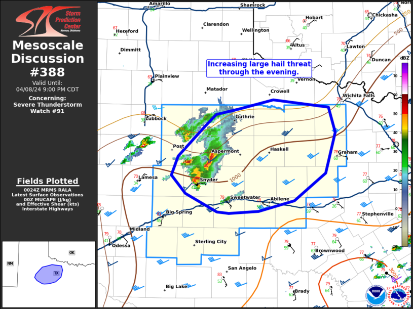
Mesoscale Discussion 0388
NWS Storm Prediction Center Norman OK
0140 PM CDT Sun Apr 12 2026

Areas affected...portions of northern Utah into eastern Idaho...far
western Wyoming...extreme southwestern Montana

Concerning...Severe potential...Watch unlikely

Valid 121840Z - 122045Z

Probability of Watch Issuance...5 percent

SUMMARY...A few severe gusts may occur with the strongest storms
that can mature over the next several hours. The severe threat
should remain isolated.

DISCUSSION...Clearing skies are supporting boundary-layer
mixing/destabilization amid the approach of a 500 mb vort max,
resulting in increased lift for convective development. Visible
satellite imagery depicts deepening CU, with NLDN lightning data
already showing a few lightning flashes in spots. Storms should
continue to increase in coverage and intensity through the afternoon
given 8+ C/km mid-level lapse rates amid 30 kts of effective bulk
shear. Storms should be mainly multicellular, the strongest of which
may be accompanied by occasional strong wind gusts (a few of which
may be severe, especially in higher-terrain areas), and perhaps an
instance or two of hail. Given the modest speed shear, the severe
threat should remain isolated at best, so a WW issuance is not
expected.

..Squitieri/Mosier.. 04/12/2026

...Please see www.spc.noaa.gov for graphic product...

ATTN...WFO...RIW...TFX...SLC...PIH...MSO...BOI...LKN...

LAT...LON   41451373 41571385 42281435 42551434 43131422 44151393
            44961322 45031241 44951142 44651061 44171030 42791005
            41641001 40751026 40321090 40091188 40131251 40511325
            41451373

MOST PROBABLE PEAK WIND GUST...55-70 MPH
MOST PROBABLE PEAK HAIL SIZE...UP TO 1.25 IN
Read morehttps://www.spc.noaa.gov/products/md/md0388.html
|
|


CMS The Best Conveyancing solicitors conveyancing quotes throughout the UK
For any webhosting enquiries please email webmaster@aus-city.com
|
|
Forums60
Topics789,765
Posts824,543
Members2,960
| |
Most Online102,106
Jul 10th, 2026
|
|
|
|
|
Copyright 1996 - 2026 by David Cottle. Designed by David Bate Jr. All Rights Reserved.
By using this forum, the user agrees not to transfer any data or technical information received under this agreement to any other entity without the express approval of the AUS-CITY Forum Admins and/or authors of individual posts (Forum Admins and DoD/USSPACECOM for the analysis of satellite tracking data).
Two-line elements (TLE) and all other satellite data presented and distributed via this forum and AUS-CITY mailing lists are distributed with permission from DoD/USSTRATCOM.

|

|


 - Click image for larger picture.")


