|
1 members (Webmaster),
5,897
guests, and
22
robots. |
|
Key:
Admin,
Global Mod,
Mod
|
|
S |
M |
T |
W |
T |
F |
S |
|
|
|
|
|
|
1
|
2
|
|
3
|
4
|
5
|
6
|
7
|
8
|
9
|
|
10
|
11
|
12
|
13
|
14
|
15
|
16
|
|
17
|
18
|
19
|
20
|
21
|
22
|
23
|
|
24
|
25
|
26
|
27
|
28
|
29
|
30
|
|
31
|
|
|
|
|
|
|
|
There are no members with birthdays on this day. |
|
|
|
|
SPC MD 657
by Webmaster - Thu 07 May 2026 12:00:AM
|
|
|
|
|
|
|
|
|
|
|
|
|
|
|
|
|
Joined: Feb 2001
Posts: 381,904
Launch Director
|
OP

Launch Director
Joined: Feb 2001
Posts: 381,904 |
SPC MD 657MD 0657 CONCERNING TORNADO WATCH 186... FOR SOUTHERN MISSISSIPPI 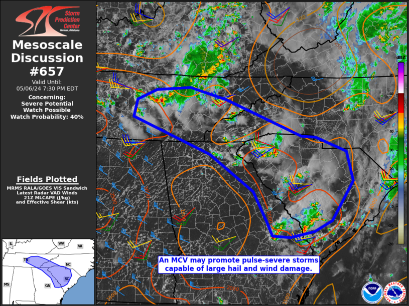
Mesoscale Discussion 0657
NWS Storm Prediction Center Norman OK
0607 PM CDT Wed May 06 2026

Areas affected...southern Mississippi

Concerning...Tornado Watch 186...

Valid 062307Z - 070030Z

The severe weather threat for Tornado Watch 186 continues.

SUMMARY...Supercells showing signs of intensification and increasing
tornado potential.

DISCUSSION...Supercells crossing the LA/MS border and across
southern MS have shown an uptick in intensity over the last 30
minutes. VAD profiles from HDC (Hammond,LA) show increasing the
850-700 mb flow beginning to be analyzed just south of the MS
border. This increase in the low to mid-level flow will aid in
increasing low level shear and thusly an increase in the tornado
threat this evening.

The cell moving into Walthall County MS has had a tornado reported
with it over the last 30 minutes. This cell will continue into a
favorable thermodynamic environment across southern MS, where
moderate to strong MLCAPE overlaps strong deep layer shear around
50-65 kts. This shows signs of cycling and strengthening. This will
continue to pose a risk for tornadoes including potential for a
strong tornado.

Two other supercells across Concordia County LA and across Copiah
County in MS are also become better organized in the low-levels.
These are also moving within a very favorable thermodynamic
environment and may also pose a risk for tornadoes over the next few
hours.

..Thornton.. 05/06/2026

...Please see www.spc.noaa.gov for graphic product...

ATTN...WFO...JAN...LIX...LCH...SHV...

LAT...LON   31509204 31729168 32239065 32379041 32558996 32528956
            32388919 32208908 32018908 31838910 31488919 31208934
            30849017 30799075 31219188 31509204

MOST PROBABLE PEAK TORNADO INTENSITY...120-145 MPH
MOST PROBABLE PEAK WIND GUST...55-70 MPH
MOST PROBABLE PEAK HAIL SIZE...1.50-2.50 IN
Read morehttps://www.spc.noaa.gov/products/md/md0657.html
|
|


CMS The Best Conveyancing solicitors conveyancing quotes throughout the UK
For any webhosting enquiries please email webmaster@aus-city.com
|
|
Forums60
Topics772,014
Posts806,802
Members2,958
| |
Most Online17,963
Jan 15th, 2026
|
|
|


 - Click image for larger picture.")


