|
|
|
0 members (),
2,260
guests, and
25
robots. |
|
Key:
Admin,
Global Mod,
Mod
|
|
S |
M |
T |
W |
T |
F |
S |
|
|
|
|
1
|
2
|
3
|
4
|
|
5
|
6
|
7
|
8
|
9
|
10
|
11
|
|
12
|
13
|
14
|
15
|
16
|
17
|
18
|
|
19
|
20
|
21
|
22
|
23
|
24
|
25
|
|
26
|
27
|
28
|
29
|
30
|
31
|
|
|
There are no members with birthdays on this day. |

Volcano earthquake report for Friday, 10 Jul 2026
• Moderate mag. 4.2 earthquake - 133 km northwest of Ternate, Kota Ternate, N...
• World Earthquake Report for Friday, 10 July 2026
• Moderate mag. 4.6 earthquake - 17 km southwest of Comalapa, Estado de Chiap...
• Moderate mag. 4.1 earthquake - Olyutorskiy Rayon, 47 km northwest of Tilich...
• Moderate mag. 4.0 earthquake - Hawke's Bay, New Zealand, on Saturday, Jul 1...
|

#811680
Mon 18 May 2026 12:40:AM
|
Joined: Feb 2001
Posts: 678,976
Launch Director
|
OP

Launch Director
Joined: Feb 2001
Posts: 678,976 |
SPC Tornado Watch 217WW 217 TORNADO KS 180040Z - 180400Z 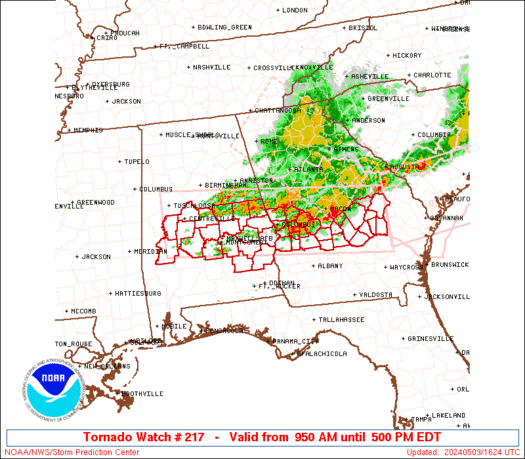
URGENT - IMMEDIATE BROADCAST REQUESTED
Tornado Watch Number 217
NWS Storm Prediction Center Norman OK
740 PM CDT Sun May 17 2026

The NWS Storm Prediction Center has issued a

* Tornado Watch for portions of
  Southwest Kansas

* Effective this Sunday evening from 740 PM until 1100 PM CDT.

* Primary threats include...
  A couple tornadoes possible
  Scattered large hail and isolated very large hail events to 2.5
    inches in diameter possible
  Isolated damaging wind gusts to 70 mph possible

SUMMARY...Intensifying thunderstorms will likely pose a risk for
large to very large hail this evening as storms develop near a cold
front and retreating dryline.  A couple of tornadoes are possible,
especially if a supercell can become established as low-level wind
shear strengthens this evening.

The tornado watch area is approximately along and 45 statute miles
east and west of a line from 30 miles northeast of Russell KS to 35
miles southeast of Dodge City KS. For a complete depiction of the
watch see the associated watch outline update (WOUS64 KWNS WOU7).

PRECAUTIONARY/PREPAREDNESS ACTIONS...

REMEMBER...A Tornado Watch means conditions are favorable for
tornadoes and severe thunderstorms in and close to the watch
area. Persons in these areas should be on the lookout for
threatening weather conditions and listen for later statements
and possible warnings.

&&

OTHER WATCH INFORMATION...CONTINUE...WW 213...WW 214...WW
215...WW 216...

AVIATION...Tornadoes and a few severe thunderstorms with hail
surface and aloft to 2.5 inches. Extreme turbulence and surface wind
gusts to 60 knots. A few cumulonimbi with maximum tops to 500. Mean
storm motion vector 23025.

...Smith
Read morehttps://www.spc.noaa.gov/products/watch/ww0217.html
|
|


CMS The Best Conveyancing solicitors conveyancing quotes throughout the UK
For any webhosting enquiries please email webmaster@aus-city.com
|
|
Forums60
Topics790,436
Posts825,218
Members2,960
| |
Most Online102,106
Jul 10th, 2026
|
|
|
|
|
Copyright 1996 - 2026 by David Cottle. Designed by David Bate Jr. All Rights Reserved.
By using this forum, the user agrees not to transfer any data or technical information received under this agreement to any other entity without the express approval of the AUS-CITY Forum Admins and/or authors of individual posts (Forum Admins and DoD/USSPACECOM for the analysis of satellite tracking data).
Two-line elements (TLE) and all other satellite data presented and distributed via this forum and AUS-CITY mailing lists are distributed with permission from DoD/USSTRATCOM.

|

|


 - Click image for larger picture.")


