|
0 members (),
1,593
guests, and
41
robots. |
|
Key:
Admin,
Global Mod,
Mod
|
|
S |
M |
T |
W |
T |
F |
S |
|
|
|
|
1
|
2
|
3
|
4
|
|
5
|
6
|
7
|
8
|
9
|
10
|
11
|
|
12
|
13
|
14
|
15
|
16
|
17
|
18
|
|
19
|
20
|
21
|
22
|
23
|
24
|
25
|
|
26
|
27
|
28
|
29
|
30
|
31
|
|
|
There are no members with birthdays on this day. |
|
|
|
|
|
|
|
|
|
|
|
|
|
|
|
|
Mini-Heap
by Alisa - Wed 22 Jul 2026 01:04:PM
|
|
|
|
|
|
|

Volcano earthquake report for Friday, 10 Jul 2026
• Moderate mag. 4.2 earthquake - 133 km northwest of Ternate, Kota Ternate, N...
• World Earthquake Report for Friday, 10 July 2026
• Moderate mag. 4.6 earthquake - 17 km southwest of Comalapa, Estado de Chiap...
• Moderate mag. 4.1 earthquake - Olyutorskiy Rayon, 47 km northwest of Tilich...
• Moderate mag. 4.0 earthquake - Hawke's Bay, New Zealand, on Saturday, Jul 1...
|

#811980
Tue 19 May 2026 02:44:AM
|
Joined: Feb 2001
Posts: 678,976
Launch Director
|
OP

Launch Director
Joined: Feb 2001
Posts: 678,976 |
SPC Tornado Watch 227WW 227 TORNADO KS MO 182310Z - 190600Z 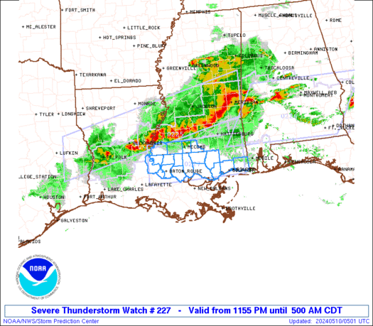
URGENT - IMMEDIATE BROADCAST REQUESTED
Tornado Watch Number 227
NWS Storm Prediction Center Norman OK
610 PM CDT Mon May 18 2026

The NWS Storm Prediction Center has issued a

* Tornado Watch for portions of
  East-Central and Southeast Kansas
  West-Central Missouri

* Effective this Monday night and Tuesday morning from 610 PM
  until 100 AM CDT.

* Primary threats include...
  A few tornadoes and a couple intense tornadoes possible
  Scattered damaging winds and isolated significant gusts to 75
    mph likely
  Scattered large hail and isolated very large hail events to 2
    inches in diameter possible

SUMMARY...A line of supercell thunderstorms is currently ongoing
along and ahead of a cold front that extends from northeast into
central KS. This line of storms is expected to continue
eastward/southeastward this evening, into an environment that will
remain supportive of a continued risk for all severe hazards. Any
discrete storms ahead of the line could pose a risk for a strong
tornado, with line-embedded tornadoes possible as well. There is
some potential for the development of several embedded bowing
clusters, which could result in corridors of 65 to 75 mph wind
gusts.

The tornado watch area is approximately along and 60 statute miles
north and south of a line from 5 miles west of Wichita KS to 25
miles north northeast of Knob Noster MO. For a complete depiction of
the watch see the associated watch outline update (WOUS64 KWNS
WOU7).

PRECAUTIONARY/PREPAREDNESS ACTIONS...

REMEMBER...A Tornado Watch means conditions are favorable for
tornadoes and severe thunderstorms in and close to the watch
area. Persons in these areas should be on the lookout for
threatening weather conditions and listen for later statements
and possible warnings.

&&

OTHER WATCH INFORMATION...CONTINUE...WW 222...WW 224...WW
225...WW 226...

AVIATION...Tornadoes and a few severe thunderstorms with hail
surface and aloft to 2 inches. Extreme turbulence and surface wind
gusts to 65 knots. A few cumulonimbi with maximum tops to 500. Mean
storm motion vector 24035.

...Mosier
Read morehttps://www.spc.noaa.gov/products/watch/ww0227.html
|
|


CMS The Best Conveyancing solicitors conveyancing quotes throughout the UK
For any webhosting enquiries please email webmaster@aus-city.com
|
|
Forums60
Topics790,239
Posts825,019
Members2,960
| |
Most Online102,106
Jul 10th, 2026
|
|
|


 - Click image for larger picture.")


