|
2 members (Webmaster, Alisa),
2,355
guests, and
27
robots. |
|
Key:
Admin,
Global Mod,
Mod
|
|
S |
M |
T |
W |
T |
F |
S |
|
|
|
|
|
|
1
|
2
|
|
3
|
4
|
5
|
6
|
7
|
8
|
9
|
|
10
|
11
|
12
|
13
|
14
|
15
|
16
|
|
17
|
18
|
19
|
20
|
21
|
22
|
23
|
|
24
|
25
|
26
|
27
|
28
|
29
|
30
|
|
31
|
|
|
|
|
|
|
|
There are no members with birthdays on this day. |
|
|
|
|
|
|
|
|
|
|
|
|
|
|
by Webmaster - Tue 19 May 2026 09:22:PM
|
by Webmaster - Tue 19 May 2026 09:22:PM
|
by Webmaster - Tue 19 May 2026 09:22:PM
|

World Earthquake Report for Tuesday, 19 May 2026
• Volcano earthquake report for Tuesday, 19 May 2026
• Significant magnitude 5.5 quake hits 83 km southeast of Uchkuduk, Uzbekista...
• Strong mag. 5.0 earthquake - 90 km south of Uchkuduk, Bukhara Region, Uzbek...
• Moderate tremor of magnitude 4.0 just reported 25 km southwest of Puerto Va...
• Seismic-like event, possible earthquake, reported few minutes ago near Puer...
|
|
|
Joined: Feb 2001
Posts: 381,904
Launch Director
|
OP

Launch Director
Joined: Feb 2001
Posts: 381,904 |
SPC Severe Thunderstorm Watch 230WW 230 SEVERE TSTM IN MI OH LE LH 191800Z - 192300Z 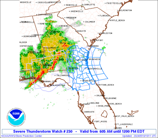
URGENT - IMMEDIATE BROADCAST REQUESTED
Severe Thunderstorm Watch Number 230
NWS Storm Prediction Center Norman OK
200 PM EDT Tue May 19 2026

The NWS Storm Prediction Center has issued a

* Severe Thunderstorm Watch for portions of
  Northeast Indiana
  Southeast Lower Michigan
  Northwest Ohio
  Lake Erie
  Lake Huron

* Effective this Tuesday afternoon and evening from 200 PM until
  700 PM EDT.

* Primary threats include...
  Scattered damaging wind gusts to 70 mph possible
  Isolated large hail events to 1 inch in diameter possible

SUMMARY...Thunderstorms are beginning to develop across
south-central Lower Michigan and northeast Indiana.  This activity
will spread northeastward across the watch area through the
afternoon, posing a risk of locally damaging wind gusts and hail.

The severe thunderstorm watch area is approximately along and 60
statute miles east and west of a line from 60 miles north northeast
of Mount Clemens MI to 40 miles east southeast of Fort Wayne IN. For
a complete depiction of the watch see the associated watch outline
update (WOUS64 KWNS WOU0).

PRECAUTIONARY/PREPAREDNESS ACTIONS...

REMEMBER...A Severe Thunderstorm Watch means conditions are
favorable for severe thunderstorms in and close to the watch area.
Persons in these areas should be on the lookout for threatening
weather conditions and listen for later statements and possible
warnings. Severe thunderstorms can and occasionally do produce
tornadoes.

&&

AVIATION...A few severe thunderstorms with hail surface and aloft to
1 inch. Extreme turbulence and surface wind gusts to 60 knots. A few
cumulonimbi with maximum tops to 500. Mean storm motion vector
24035.

...Hart
Read morehttps://www.spc.noaa.gov/products/watch/ww0230.html
|
|


CMS The Best Conveyancing solicitors conveyancing quotes throughout the UK
For any webhosting enquiries please email webmaster@aus-city.com
|
|
Forums60
Topics775,511
Posts810,303
Members2,960
| |
Most Online22,463
May 9th, 2026
|
|
|


 - Click image for larger picture.")


