|
|
|
0 members (),
1,211
guests, and
107
robots. |
|
Key:
Admin,
Global Mod,
Mod
|
|
S |
M |
T |
W |
T |
F |
S |
|
|
|
|
1
|
2
|
3
|
4
|
|
5
|
6
|
7
|
8
|
9
|
10
|
11
|
|
12
|
13
|
14
|
15
|
16
|
17
|
18
|
|
19
|
20
|
21
|
22
|
23
|
24
|
25
|
|
26
|
27
|
28
|
29
|
30
|
31
|
|
|
There are no members with birthdays on this day. |

World Earthquake Report for Sunday, 26 July 2026
• Moderate mag. 4.5 earthquake - Estado de Veracruz-Llave, Mexico, on 2026-07...
• Volcano earthquake report for Sunday, 26 Jul 2026
• Moderate mag. 4.0 earthquake - Kabupaten Kepulauan Talaud, 148 km northeast...
• Light mag. 3.9 earthquake - North Pacific Ocean, 65 km south of Puerto San ...
• Strong mag. 5.4 earthquake - Northern Mid-Atlantic Ridge on Sunday, Jul 26,...
|

#817458
Fri 12 Jun 2026 04:50:AM
|
Joined: Feb 2001
Posts: 678,976
Launch Director
|
OP

Launch Director
Joined: Feb 2001
Posts: 678,976 |
Volcano earthquake report for Friday, 12 Jun 2026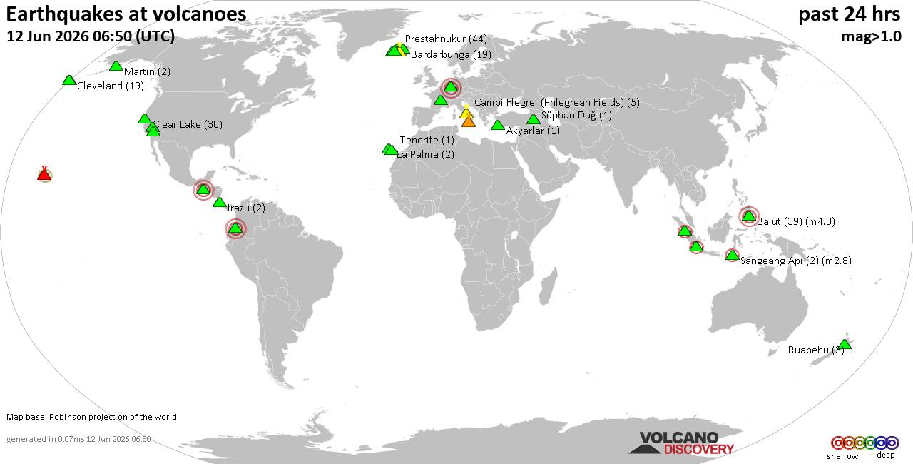 World map showing volcanoes with shallow (less than 50 km) earthquakes within 20 km radius during the past 24 hours on 12 Jun 2026 Number in brackets indicate nr of quakes. Quakes detected near: Agua (2 quakes between mag 3.0-3.0), Akyarlar (1 quake mag 1.4), Balut (40 quakes between mag 1.3-4.3), Bardarbunga (18 quakes between mag 0.0-1.1), Brennisteinsfjöll (6 quakes between mag 0.2-1.4), Campi Flegrei (Phlegrean Fields) (6 quakes between mag 0.1-1.7)
Chaîne des Puys (1 quake mag 1.2), Clear Lake (28 quakes between mag 0.2-1.3), Cleveland (19 quakes between mag 0.0-1.5), Coso (1 quake mag 1.4), Eldey (8 quakes between mag 0.4-1.4), Etna (2 quakes between mag 1.6-2.0), Galeras (1 quake mag 3.0), Hulubelu (2 quakes between mag 2.2-2.3), Irazu (2 quakes between mag 1.1-1.4), Katla (4 quakes between mag 0.0-1.3), Kilauea (3 quakes between mag 1.7-2.7), La Palma (2 quakes between mag 0.7-1.5), Laacher See (1 quake mag 3.0), Lavic Lake (1 quake mag 1.2), Martin (2 quakes between mag 0.5-1.1), Prestahnukur (34 quakes between mag 0.7-2.0), Ruapehu (3 quakes between mag 0.4-1.0), Sangeang Api (2 quakes between mag 2.5-2.8), Süphan Dağ (1 quake mag 1.5), Talakmau (1 quake mag 2.5), Tana (4 quakes between mag 0.3-1.1), Vatnafjöll (1 quake mag 2.1) (updated 04h50)
Note: Earthquakes within 20 km from and at depths less than 50 km under active volcanoes are reported. The list is not complete because many volcanoes are not monitored and/or seismic data in high resolution is not available publicly.
Volcanoes with recent earthquakes above magnitude 2 or more than 10 quakes are listed below:
Agua volcano (Guatemala): 2 earthquakes up to magnitude 3.02 earthquakes occurred near (under) the volcano during 22 hours, the last being recorded quake 44 minutes ago. Hypocenter depths ranged between 10.00 and 1.00 km. Earthquake details: Unconfirmed quake or seismic-like event reported: 28 km southwest of Guatemala City, Departamento de Guatemala, Guatemala, Jun 11, 2026 10:06 pm (GMT -6) (6 km N) 3.0 quake 2.3 km northwest of Palin, Departamento de Escuintla, Guatemala, Jun 10, 2026 11:59 pm (GMT -6) (6 km SE) All earthquakes at AguaBalut volcano (Mindanao): 40 earthquakes up to magnitude 4.3Possible earthquake swarm: 40 earthquakes occurred near (under) the volcano during 24 hours, the last being recorded quake 23 minutes ago. Hypocenter depths ranged between 46.00 and 2.00 km. Earthquake details: (only 5 largest) 4.3 quake Philippine Sea, 12 km southwest of Sarangani Island, Philippines, Jun 12, 2026 12:43 am (GMT +8) (5 km SSE) 4.0 quake Philippine Sea, 26 km southwest of Sarangani Island, Philippines, Jun 11, 2026 12:50 pm (GMT +8) (19 km S) 3.9 quake Philippine Sea, 17 km south of Sarangani Island, Philippines, Jun 12, 2026 05:19 am (GMT +8) (17 km SE) 3.9 quake Province of Davao del Sur, 0.9 km northwest of Sarangani, Philippines, Jun 12, 2026 05:57 am (GMT +8) (9 km E) 3.8 quake Philippine Sea, 18 km northwest of Sarangani Island, Philippines, Jun 12, 2026 09:50 am (GMT +8) (13 km NNW) All earthquakes at BalutBardarbunga volcano (Iceland): 18 earthquakes up to magnitude 1.1Possible earthquake swarm: 18 earthquakes occurred near (under) the volcano during 18 hours, the last being recorded quake 3 hours ago. Hypocenter depths ranged between 7.80 and 0.00 km. Earthquake details: (only 5 largest) 1.1 quake Iceland: 5.8 km ESE of Bárðarbunga Jun 11, 2026 03:35 pm (Reykjavik time) (6 km E) 1.0 quake 5.3 km ESE of Bárðarbunga Jun 12, 2026 01:44 am (Universal Time) (5 km E) 1.0 quake Iceland: 3.6 km SSE of Bárðarbunga Jun 11, 2026 08:04 pm (Reykjavik time) (3 km SE) 1.0 quake 2.6 km SSE of Bárðarbunga Jun 11, 2026 09:53 am (Universal Time) (2 km ESE) 0.6 quake 4.1 km SE of Bárðarbunga Jun 11, 2026 11:17 am (Universal Time) (3 km ESE) All earthquakes at BardarbungaClear Lake volcano (California): 28 earthquakes up to magnitude 1.3Possible earthquake swarm: 28 earthquakes occurred near (under) the volcano during 22 hours, the last being recorded quake 49 minutes ago. Hypocenter depths ranged between 8.92 and 1.01 km. Earthquake details: (only 5 largest) 1.3 quake 27 mi north of Santa Rosa, Sonoma County, California, United States, Jun 11, 2026 07:52 am (GMT -7) (17 km S) 1.3 quake 27 mi north of Santa Rosa, Sonoma County, California, United States, Jun 11, 2026 04:15 am (GMT -7) (18 km SSW) 1.3 quake 28 mi north of Santa Rosa, Sonoma County, California, United States, Jun 11, 2026 05:41 am (GMT -7) (16 km SSW) 1.2 quake Mendocino County, 30 mi north of Santa Rosa, Sonoma County, California, United States, Jun 11, 2026 01:40 pm (GMT -7) (14 km SSW) 1.2 quake 26 mi north of Santa Rosa, Sonoma County, California, United States, Jun 11, 2026 12:20 pm (GMT -7) (18 km SSW) All earthquakes at Clear LakeCleveland volcano (Aleutian Islands): 19 earthquakes up to magnitude 1.5Possible earthquake swarm: 19 earthquakes occurred near (under) the volcano during 12 hours, the last being recorded quake 11 hours ago. Hypocenter depths ranged between 9.73 and 2.32 km. Earthquake details: (only 5 largest) 1.5 quake 43 mi west of Nikolski, Aleutians West Census Area, Alaska, United States, Jun 11, 2026 05:25 am (GMT -9) (4 km E) 1.5 quake 44 mi west of Nikolski, Aleutians West Census Area, Alaska, United States, Jun 11, 2026 05:25 am (GMT -9) (4 km E) 1.0 quake Bering Sea, 3.2 mi southwest of Chuginadak Island, Aleutians West Census Area, Alaska, United States, Jun 10, 2026 09:57 pm (GMT -9) (5 km ESE) 0.6 quake 45 mi west of Nikolski, Aleutians West Census Area, Alaska, United States, Jun 11, 2026 06:23 am (GMT -9) (2 km NE) 0.5 quake 43 mi west of Nikolski, Aleutians West Census Area, Alaska, United States, Jun 10, 2026 08:27 pm (GMT -9) (5 km E) All earthquakes at ClevelandGaleras volcano (Colombia): magnitude 3.0 earthquakeA magnitude 3.0 earthquake occurred at the volcano 15 hours ago. The quake, which might be volcanic in origin, was located at a depth of 10.00 km depth at 9 km distance E from the volcano. Earthquake details: Reported seismic-like event (likely no quake): 1.7 km northwest of Pasto, Departamento de Narino, Colombia, Jun 11, 2026 09:10 am (GMT -5) (9 km E) All earthquakes at GalerasHulubelu volcano (Sumatra): 2 earthquakes up to magnitude 2.32 earthquakes occurred near (under) the volcano during 6 minutes, the last being recorded quake 12 hours ago. Hypocenter depths ranged between 5.00 and 3.00 km. Earthquake details: 2.3 quake Kabupaten Tanggamus, 70 km west of Bandar Lampung, Indonesia, Jun 11, 2026 11:14 pm (GMT +7) (7 km SE) 2.2 quake Kabupaten Tanggamus, 69 km west of Bandar Lampung, Indonesia, Jun 11, 2026 11:20 pm (GMT +7) (8 km SE) All earthquakes at HulubeluKilauea volcano (Hawai'i (Big Island)): 3 earthquakes up to magnitude 2.73 earthquakes occurred near (under) the volcano during 5 hours, the last being recorded quake 15 hours ago. Hypocenter depths ranged between 30.83 and 0.29 km. Earthquake details: 2.7 quake 21 mi southwest of Hilo, Hawaii County, Hawaii, United States, Jun 11, 2026 03:33 am (GMT -10) (8 km NNE) 2.6 quake 22 mi southwest of Hilo, Hawaii County, Hawaii, United States, Jun 11, 2026 03:34 am (GMT -10) (6 km NE) 1.7 quake 37 mi southwest of Hilo, Hawaii County, Hawaii, United States, Jun 10, 2026 10:57 pm (GMT -10) (19 km SSW) All earthquakes at KilaueaLaacher See volcano (Germany): magnitude 3.0 earthquakeA magnitude 3.0 earthquake occurred at the volcano 9 hours ago. The quake, which might be volcanic in origin, was located at a depth of 10.00 km depth at 16 km distance S from the volcano. Earthquake details: Reported seismic-like event (likely no quake): 22 km southwest of Koblenz, Kreisfreie Stadt Pirmasens, Rheinland-Pfalz, Germany, Jun 11, 2026 10:17 pm (GMT +2) (16 km S) All earthquakes at Laacher SeePrestahnukur volcano (Iceland): 34 earthquakes up to magnitude 2.0Possible earthquake swarm: 34 earthquakes occurred near (under) the volcano during 18 hours, the last being recorded quake 29 minutes ago. Hypocenter depths ranged between 20.90 and 0.00 km. Earthquake details: (only 5 largest) 2.0 quake Iceland: 14.8 km SSE of Húsafell Jun 11, 2026 09:32 pm (Reykjavik time) (11 km WSW) 1.9 quake 15.4 km SSE of Húsafell Jun 11, 2026 09:29 pm (Universal Time) (12 km WSW) 1.7 quake Iceland: 15.0 km SSE of Húsafell Jun 11, 2026 09:28 pm (Reykjavik time) (10 km WSW) 1.6 quake Iceland: 16.1 km SSE of Húsafell Jun 11, 2026 07:50 pm (Reykjavik time) (11 km WSW) 1.5 quake 15.5 km SSE of Húsafell Jun 11, 2026 11:19 pm (Universal Time) (10 km WSW) All earthquakes at PrestahnukurSangeang Api volcano (Lesser Sunda Islands): 2 earthquakes up to magnitude 2.82 earthquakes occurred near (under) the volcano during 1 hour 39 minutes, the last being recorded quake 9 hours ago. Hypocenter depths ranged between 12.00 and 11.00 km. Earthquake details: 2.8 quake Flores Sea, 16 km northwest of Pulau Sangeang Island, Indonesia, Jun 12, 2026 01:51 am (GMT +8) (17 km NW) 2.5 quake Flores Sea, 17 km northwest of Pulau Sangeang Island, Indonesia, Jun 12, 2026 03:29 am (GMT +8) (17 km NNW) All earthquakes at Sangeang ApiTalakmau volcano (Sumatra): magnitude 2.5 earthquakeA magnitude 2.5 earthquake occurred at the volcano 19 hours ago. The quake, which might be volcanic in origin, was located at a depth of 6.00 km depth at 5 km distance NE from the volcano. Earthquake details: 2.5 quake Kabupaten Pasaman, 62 km northwest of Bukittinggi, Indonesia, Jun 11, 2026 04:35 pm (GMT +7) (5 km NE) All earthquakes at TalakmauVatnafjöll volcano (Iceland): magnitude 2.1 earthquakeA magnitude 2.1 earthquake occurred at the volcano 5 hours ago. The quake, which might be volcanic in origin, was located at a depth of 4.50 km depth at 10 km distance W from the volcano. Earthquake details: 2.1 quake 11.1 km W of Vatnafjöll Jun 12, 2026 12:03 am (Universal Time) (10 km W) All earthquakes at Vatnafjöllhttps://www.volcanodiscovery.com/earthquakes-volcanoes/news/305230/Volcano-earthquake-report-for-Friday-12-Jun-2026.html
|
|


CMS The Best Conveyancing solicitors conveyancing quotes throughout the UK
For any webhosting enquiries please email webmaster@aus-city.com
|
|
Forums60
Topics793,270
Posts828,053
Members2,960
| |
Most Online102,106
Jul 10th, 2026
|
|
|
|
|
Copyright 1996 - 2026 by David Cottle. Designed by David Bate Jr. All Rights Reserved.
By using this forum, the user agrees not to transfer any data or technical information received under this agreement to any other entity without the express approval of the AUS-CITY Forum Admins and/or authors of individual posts (Forum Admins and DoD/USSPACECOM for the analysis of satellite tracking data).
Two-line elements (TLE) and all other satellite data presented and distributed via this forum and AUS-CITY mailing lists are distributed with permission from DoD/USSTRATCOM.

|

|


 - Click image for larger picture.")


