|
|
|
0 members (),
1,997
guests, and
27
robots. |
|
Key:
Admin,
Global Mod,
Mod
|
|
S |
M |
T |
W |
T |
F |
S |
|
|
1
|
2
|
3
|
4
|
5
|
6
|
|
7
|
8
|
9
|
10
|
11
|
12
|
13
|
|
14
|
15
|
16
|
17
|
18
|
19
|
20
|
|
21
|
22
|
23
|
24
|
25
|
26
|
27
|
|
28
|
29
|
30
|
|
|
|
|

World Earthquake Report for Saturday, 13 June 2026
• Moderate mag. 4.0 earthquake - 12 km south of Baukau, Baucau, Timor-Leste, ...
• Volcano earthquake report for Saturday, 13 Jun 2026
• Moderate mag. 4.1 earthquake - Indian Ocean, 149 km south of Yogyakarta, In...
• Moderate mag. 4.3 earthquake - Provincia de Cardenal Caro, Region del Liber...
• Moderate mag. 4.0 earthquake - 29 km southwest of Huetamo de Nunez, Estado ...
|

#818021
Fri 12 Jun 2026 11:50:PM
|
Joined: Feb 2001
Posts: 678,976
Launch Director
|
OP

Launch Director
Joined: Feb 2001
Posts: 678,976 |
Volcano earthquake report for Friday, 12 Jun 2026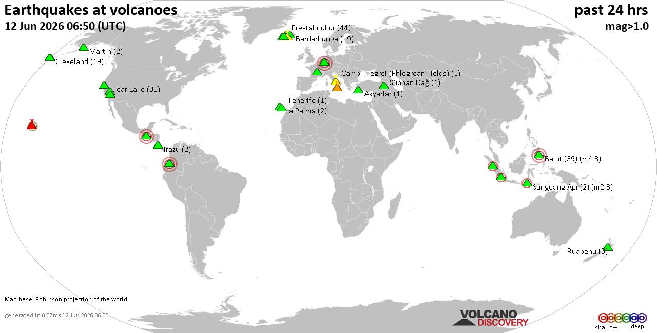 World map showing volcanoes with shallow (less than 50 km) earthquakes within 20 km radius during the past 24 hours on 12 Jun 2026 Number in brackets indicate nr of quakes. Quakes detected near: Agua (1 quake mag 3.0), Agung (1 quake mag 2.1), Balut (53 quakes between mag 1.4-4.1), Canlaon (1 quake mag 1.9), Clear Lake (21 quakes between mag 0.7-2.0), Cleveland (6 quakes between mag 0.0-1.5)
Coso (1 quake mag 1.0), El Hierro (1 quake mag 1.5), Eldey (3 quakes between mag 1.1-1.6), Etna (1 quake mag 1.9), Hulubelu (1 quake mag 2.1), Itasy Volcanic Field (1 quake mag 1.8), Kagamil (1 quake mag 1.9), Katla (3 quakes between mag 0.2-1.0), La Palma (4 quakes between mag 0.7-1.5), Masaya (1 quake mag 2.1), Maunaloa (1 quake mag 1.2), Methana (1 quake mag 1.5), Ontake-san (1 quake mag 2.7), Parker (2 quakes between mag 1.6-2.6), Pelée (9 quakes between mag 0.1-1.7), Poas (1 quake mag 1.3), Prestahnukur (45 quakes between mag 0.4-1.8), Reporoa (1 quake mag 1.6), Rinjani (1 quake mag 3.2), Ruang (1 quake mag 2.7), Ruapehu (2 quakes between mag 0.7-1.0), Soda Lakes (1 quake mag 4.0), Stepovak Bay 4 (1 quake mag 2.1), Tambora (1 quake mag 2.1), Tenerife (3 quakes between mag 1.1-3.0), Tenorio (1 quake mag 2.1), Thordarhyrna (1 quake mag 1.0), Uliaga (1 quake mag 2.1), Vatnafjöll (1 quake mag 2.1) (updated 23h50)
Note: Earthquakes within 20 km from and at depths less than 50 km under active volcanoes are reported. The list is not complete because many volcanoes are not monitored and/or seismic data in high resolution is not available publicly.
Volcanoes with recent earthquakes above magnitude 2 or more than 10 quakes are listed below:
Agua volcano (Guatemala): magnitude 3.0 earthquakeA magnitude 3.0 earthquake occurred at the volcano 20 hours ago. The quake, which might be volcanic in origin, was located at a depth of 10.00 km depth at 6 km distance N from the volcano. Earthquake details: Reported seismic-like event (likely no quake): 28 km southwest of Guatemala City, Departamento de Guatemala, Guatemala, Jun 11, 2026 10:06 pm (GMT -6) (6 km N) All earthquakes at AguaAgung volcano (Bali): magnitude 2.1 earthquakeA magnitude 2.1 earthquake occurred at the volcano 5 hours ago. The quake, which might be volcanic in origin, was located at a depth of 11.00 km depth at 15 km distance SW from the volcano. Earthquake details: 2.1 quake Kabupaten Karang Asem, 19 km northeast of Ubud, Indonesia, Jun 13, 2026 02:35 am (GMT +8) (15 km SW) All earthquakes at AgungBalut volcano (Mindanao): 53 earthquakes up to magnitude 4.1Possible earthquake swarm: 53 earthquakes occurred near (under) the volcano during 22 hours, the last being recorded quake 24 minutes ago. Hypocenter depths ranged between 44.00 and 2.00 km. Earthquake details: (only 5 largest) 4.1 quake Celebes Sea, 15 km south of Sarangani Island, Philippines, Jun 13, 2026 12:48 am (Manila time) (17 km SE) 4.0 quake Philippine Sea, 7.6 km southeast of Sarangani Island, Philippines, Jun 12, 2026 11:28 pm (Manila time) (17 km E) 4.0 quake Davao, 98 km southeast of General Santos, Philippines, Jun 12, 2026 11:57 pm (Manila time) (19 km SE) 4.0 quake Philippine Sea, 8.1 km south of Sarangani, Davao Occidental, Davao, Philippines, Jun 13, 2026 05:21 am (Manila time) (12 km SE) 4.0 quake Celebes Sea, 23 km southwest of Sarangani Island, Philippines, Jun 12, 2026 04:39 pm (Manila time) (13 km SSW) All earthquakes at BalutClear Lake volcano (California): 21 earthquakes up to magnitude 2.0Possible earthquake swarm: 21 earthquakes occurred near (under) the volcano during 23 hours, the last being recorded quake 58 minutes ago. Hypocenter depths ranged between 3.80 and 1.01 km. Earthquake details: (only 5 largest) 2.0 quake Sonoma County, 13 mi southwest of Clearlake, Lake County, California, United States, Jun 12, 2026 03:51 pm (GMT -7) (15 km SSW) 1.4 quake 27 mi north of Santa Rosa, Sonoma County, California, United States, Jun 11, 2026 11:18 pm (GMT -7) (18 km SSW) 1.3 quake 27 mi north of Santa Rosa, Sonoma County, California, United States, Jun 12, 2026 10:14 am (GMT -7) (17 km S) 1.3 quake 26 mi north of Santa Rosa, Sonoma County, California, United States, Jun 12, 2026 09:25 am (GMT -7) (18 km S) 1.2 quake 27 mi north of Santa Rosa, Sonoma County, California, United States, Jun 11, 2026 09:46 pm (GMT -7) (16 km SSW) All earthquakes at Clear LakeHulubelu volcano (Sumatra): magnitude 2.1 earthquakeA magnitude 2.1 earthquake occurred at the volcano 4 hours ago. The quake, which might be volcanic in origin, was located at a depth of 6.00 km depth at 7 km distance SSE from the volcano. Earthquake details: 2.1 quake Kabupaten Tanggamus, 72 km west of Bandar Lampung, Indonesia, Jun 13, 2026 02:44 am (GMT +7) (7 km SSE) All earthquakes at HulubeluMasaya volcano (Nicaragua): magnitude 2.1 earthquakeA magnitude 2.1 earthquake occurred at the volcano 6 hours ago. The quake, which might be volcanic in origin, was located at a depth of 35.00 km depth at 9 km distance N from the volcano. Earthquake details: 2.1 quake Departamento de Masaya, 12 km southeast of Managua, Nicaragua, Jun 12, 2026 11:59 am (GMT -6) (9 km N) All earthquakes at MasayaOntake-san volcano (Honshu): magnitude 2.7 earthquakeA magnitude 2.7 earthquake occurred at the volcano 5 hours ago. The quake, which might be volcanic in origin, was located at a depth of 10.40 km depth at 10 km distance WSW from the volcano. Earthquake details: 2.7 quake Nagano, 15 km northeast of Gero, Gifu, Japan, Jun 13, 2026 04:11 am (GMT +9) (10 km WSW) All earthquakes at Ontake-sanParker volcano (Mindanao): 2 earthquakes up to magnitude 2.62 earthquakes occurred near (under) the volcano during 10 hours, the last being recorded quake 32 minutes ago. Hypocenter depths ranged between 13.00 and 3.00 km. Earthquake details: 2.6 quake Province of Sarangani, 30 km southwest of General Santos, Philippines, Jun 12, 2026 09:34 pm (GMT +8) (18 km SSE) 1.6 quake 32 km west of General Santos, Philippines, Jun 13, 2026 07:18 am (GMT +8) (10 km S) All earthquakes at ParkerPrestahnukur volcano (Iceland): 45 earthquakes up to magnitude 1.8Possible earthquake swarm: 45 earthquakes occurred near (under) the volcano during 21 hours, the last being recorded quake 2 hours ago. Hypocenter depths ranged between 19.20 and 0.00 km. Earthquake details: (only 5 largest) 1.8 quake 15.9 km SSE of Húsafell Jun 12, 2026 06:44 am (Universal Time) (11 km WSW) 1.7 quake Iceland: 15.7 km SSE of Húsafell Jun 12, 2026 04:37 pm (Reykjavik time) (10 km WSW) 1.7 quake Iceland: 15.5 km SSE of Húsafell Jun 12, 2026 04:32 pm (Reykjavik time) (10 km WSW) 1.6 quake 15.6 km SSE of Húsafell Jun 12, 2026 06:03 am (Universal Time) (12 km WSW) 1.6 quake Iceland: 15.9 km NNW of Skjaldbreið Jun 12, 2026 06:33 pm (Reykjavik time) (16 km WSW) All earthquakes at PrestahnukurRinjani volcano (Lombok): magnitude 3.2 earthquakeA magnitude 3.2 earthquake occurred at the volcano 6 hours ago. The quake, which might be volcanic in origin, was located at a depth of 10.00 km depth at 19 km distance NNW from the volcano. Earthquake details: 3.2 quake Kabupaten Lombok Utara, 45 km north of Selong, Indonesia, Jun 13, 2026 01:46 am (GMT +8) (19 km NNW) All earthquakes at RinjaniRuang volcano (Sulawesi & Sangihe Islands): magnitude 2.7 earthquakeA magnitude 2.7 earthquake occurred at the volcano 26 minutes ago. The quake, which might be volcanic in origin, was located at a depth of 5.00 km depth at 6 km distance NE from the volcano. Earthquake details: 2.7 quake Kabupaten Siau Tagulandang Biaro, 141 km south of Tahuna, Indonesia, Jun 13, 2026 07:24 am (GMT +8) (6 km NE) All earthquakes at RuangSoda Lakes volcano (Nevada): magnitude 4.0 earthquakeA magnitude 4.0 earthquake occurred at the volcano 12 hours ago. The quake, which might be volcanic in origin, was located at a depth of 2.00 km depth at 12 km distance SSW from the volcano. Earthquake details: 4.0 quake 15 mi southwest of Fallon, Churchill County, Nevada, United States, Jun 12, 2026 05:12 am (Los Angeles time) (12 km SSW) All earthquakes at Soda LakesStepovak Bay 4 volcano (Alaska Peninsula): magnitude 2.1 earthquakeA magnitude 2.1 earthquake occurred at the volcano 16 hours ago. The quake, which might be volcanic in origin, was located at a depth of 10.30 km depth at 6 km distance SSE from the volcano. Earthquake details: 2.1 quake 46 mi northeast of Sand Point, Aleutians East Borough, Alaska, United States, Jun 11, 2026 11:29 pm (GMT -8) (6 km SSE) All earthquakes at Stepovak Bay 4Tambora volcano (Sumbawa): magnitude 2.1 earthquakeA magnitude 2.1 earthquake occurred at the volcano 4 hours ago. The quake, which might be volcanic in origin, was located at a depth of 10.00 km depth at 6 km distance SSE from the volcano. Earthquake details: 2.1 quake Kabupaten Dompu, 80 km west of Bima, Kota Bima, West Nusa Tenggara, Indonesia, Jun 13, 2026 03:31 am (GMT +8) (6 km SSE) All earthquakes at TamboraTenerife volcano (Canary Islands): 3 earthquakes up to magnitude 3.03 earthquakes occurred near (under) the volcano during 16 hours, the last being recorded quake 2 hours ago. Hypocenter depths ranged between 17.00 and 10.00 km. Earthquake details: Reported seismic-like event (likely no quake): 29 km north of Adeje, Santa Cruz de Tenerife, Canary Islands, Spain, Jun 12, 2026 10:37 pm (GMT +1) (12 km N) 1.2 quake 15 km north of Arona, Santa Cruz de Tenerife, Canary Islands, Spain, Jun 12, 2026 11:41 am (GMT +1) (4 km SSW) 1.1 quake 2.8 km east of Icod de los Vinos, Santa Cruz de Tenerife, Canary Islands, Spain, Jun 12, 2026 06:21 am (GMT +1) (12 km NNW) All earthquakes at TenerifeTenorio volcano (Costa Rica): magnitude 2.1 earthquakeA magnitude 2.1 earthquake occurred at the volcano 5 hours ago. The quake, which might be volcanic in origin, was located at a depth of 8.00 km depth at 2 km distance SSW from the volcano. Earthquake details: 2.1 quake 26 km north of Canas, Provincia de Guanacaste, Costa Rica, Jun 12, 2026 12:20 pm (Costa_Rica time) (2 km SSW) All earthquakes at TenorioUliaga volcano (Aleutian Islands): magnitude 2.1 earthquakeA magnitude 2.1 earthquake occurred at the volcano 13 hours ago. The quake, which might be volcanic in origin, was located at a depth of 2.30 km depth at 2 km distance ENE from the volcano. Earthquake details: 2.1 quake Bering Sea, 5.4 mi north of Kagamil Island, Aleutians West Census Area, Alaska, United States, Jun 12, 2026 02:14 am (GMT -9) (2 km ENE) All earthquakes at UliagaVatnafjöll volcano (Iceland): magnitude 2.1 earthquakeA magnitude 2.1 earthquake occurred at the volcano 24 hours ago. The quake, which might be volcanic in origin, was located at a depth of 6.10 km depth at 10 km distance W from the volcano. Earthquake details: 2.1 quake 10.6 km W of Vatnafjöll Jun 12, 2026 12:03 am (Universal Time) (10 km W) All earthquakes at Vatnafjöllhttps://www.volcanodiscovery.com/earthquakes-volcanoes/news/305230/Volcano-earthquake-report-for-Friday-12-Jun-2026.html
|
|


CMS The Best Conveyancing solicitors conveyancing quotes throughout the UK
For any webhosting enquiries please email webmaster@aus-city.com
|
|
Forums60
Topics781,627
Posts816,385
Members2,960
| |
Most Online22,463
May 9th, 2026
|
|
|
|
|
Copyright 1996 - 2026 by David Cottle. Designed by David Bate Jr. All Rights Reserved.
By using this forum, the user agrees not to transfer any data or technical information received under this agreement to any other entity without the express approval of the AUS-CITY Forum Admins and/or authors of individual posts (Forum Admins and DoD/USSPACECOM for the analysis of satellite tracking data).
Two-line elements (TLE) and all other satellite data presented and distributed via this forum and AUS-CITY mailing lists are distributed with permission from DoD/USSTRATCOM.

|

|


 - Click image for larger picture.")


