|
0 members (),
1,755
guests, and
24
robots. |
|
Key:
Admin,
Global Mod,
Mod
|
|
S |
M |
T |
W |
T |
F |
S |
|
|
1
|
2
|
3
|
4
|
5
|
6
|
|
7
|
8
|
9
|
10
|
11
|
12
|
13
|
|
14
|
15
|
16
|
17
|
18
|
19
|
20
|
|
21
|
22
|
23
|
24
|
25
|
26
|
27
|
|
28
|
29
|
30
|
|
|
|
|
|
There are no members with birthdays on this day. |

World Earthquake Report for Sunday, 14 June 2026
• Moderate mag. 4.2 earthquake - 30 km west of Meulaboh, Indonesia, on Sunday...
• Volcano earthquake report for Sunday, 14 Jun 2026
• The 10 most powerful earthquakes in the world since 1900
• Moderate mag. 4.4 earthquake - 82 km ENE of Loikaw, Burma (Myanmar), on Mon...
• Moderate magnitude 4.8 quake hits 26 km southwest of Volos, Greece in the e...
|
|
|
Joined: Feb 2001
Posts: 678,976
Launch Director
|
OP

Launch Director
Joined: Feb 2001
Posts: 678,976 |
SPC Tornado Watch 336WW 336 TORNADO PA 142140Z - 150200Z 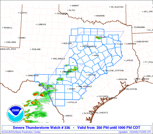
URGENT - IMMEDIATE BROADCAST REQUESTED
Tornado Watch Number 336
NWS Storm Prediction Center Norman OK
540 PM EDT Sun Jun 14 2026

The NWS Storm Prediction Center has issued a

* Tornado Watch for portions of
  Western and Central Pennsylvania

* Effective this Sunday afternoon and evening from 540 PM until
  1000 PM EDT.

* Primary threats include...
  A couple tornadoes possible
  Scattered damaging wind gusts to 70 mph likely
  Isolated large hail events to 1 inch in diameter possible

SUMMARY...Ongoing supercells and a broken line of thunderstorms
should pose a threat for a couple of tornadoes and scattered
severe/damaging winds late this afternoon and continuing into the
evening as they move eastward across parts of western and central
Pennsylvania.

The tornado watch area is approximately along and 60 statute miles
north and south of a line from 50 miles west southwest of Dubois PA
to 5 miles north of Williamsport PA. For a complete depiction of the
watch see the associated watch outline update (WOUS64 KWNS WOU6).

PRECAUTIONARY/PREPAREDNESS ACTIONS...

REMEMBER...A Tornado Watch means conditions are favorable for
tornadoes and severe thunderstorms in and close to the watch
area. Persons in these areas should be on the lookout for
threatening weather conditions and listen for later statements
and possible warnings.

&&

OTHER WATCH INFORMATION...CONTINUE...WW 333...WW 334...WW 335...

AVIATION...Tornadoes and a few severe thunderstorms with hail
surface and aloft to 1 inch. Extreme turbulence and surface wind
gusts to 60 knots. A few cumulonimbi with maximum tops to 500. Mean
storm motion vector 27035.

...Gleason
Read morehttps://www.spc.noaa.gov/products/watch/ww0336.html
|
|


CMS The Best Conveyancing solicitors conveyancing quotes throughout the UK
For any webhosting enquiries please email webmaster@aus-city.com
|
|
Forums60
Topics781,721
Posts816,479
Members2,960
| |
Most Online22,463
May 9th, 2026
|
|
|


 - Click image for larger picture.")


