|
|
|
0 members (),
2,032
guests, and
24
robots. |
|
Key:
Admin,
Global Mod,
Mod
|
|
S |
M |
T |
W |
T |
F |
S |
|
|
1
|
2
|
3
|
4
|
5
|
6
|
|
7
|
8
|
9
|
10
|
11
|
12
|
13
|
|
14
|
15
|
16
|
17
|
18
|
19
|
20
|
|
21
|
22
|
23
|
24
|
25
|
26
|
27
|
|
28
|
29
|
30
|
|
|
|
|
|
There are no members with birthdays on this day. |

Magnitude 5.3 earthquake strikes near Palu, Kota Palu, Sulawesi Tengah, Indonesia
• Strong mag. 5.2 earthquake - Kabupaten Sigi, 25 km southeast of Palu, Kota ...
• Strong mag. 5.2 earthquake - Kabupaten Sigi, 25 km southeast of Palu, Kota ...
• Volcano earthquake report for Tuesday, 16 Jun 2026
• Volcano earthquake report for Tuesday, 16 Jun 2026
|
|
|
Joined: Feb 2001
Posts: 678,976
Launch Director
|
OP

Launch Director
Joined: Feb 2001
Posts: 678,976 |
Volcano earthquake report for Tuesday, 16 Jun 2026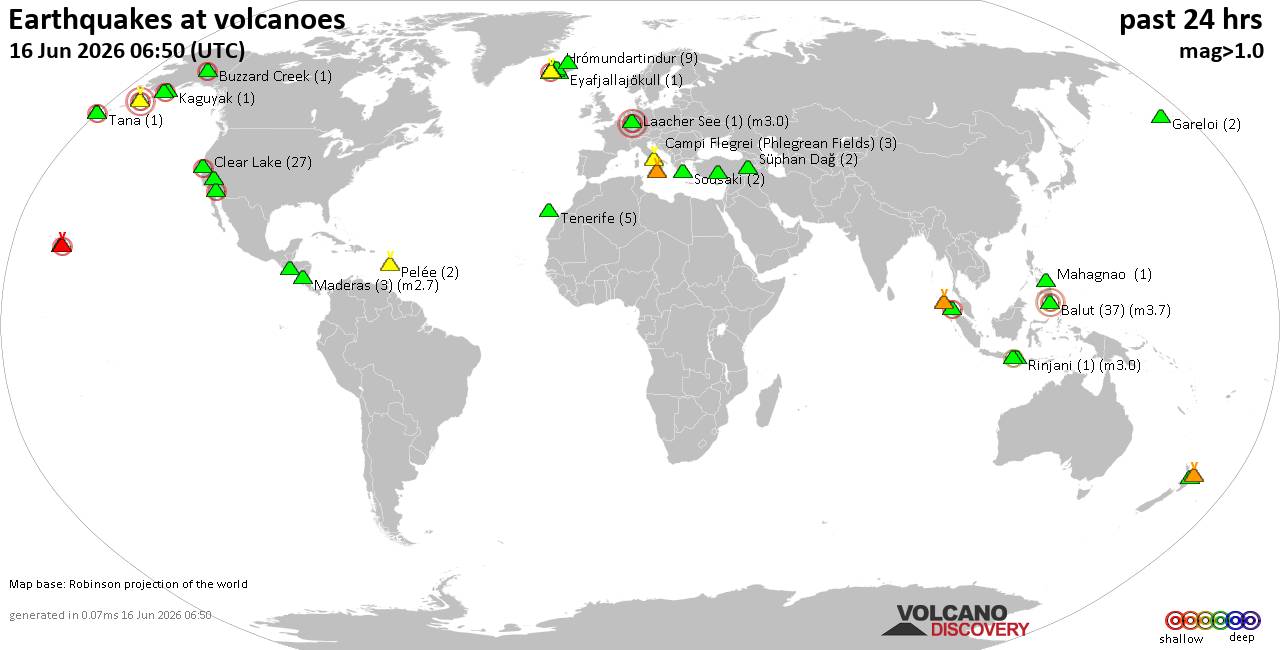 World map showing volcanoes with shallow (less than 50 km) earthquakes within 20 km radius during the past 24 hours on 16 Jun 2026 Number in brackets indicate nr of quakes. Quakes detected near: Balut (45 quakes between mag 1.3-3.9), Bratan (1 quake mag 2.2), Buzzard Creek (1 quake mag 2.0), Clear Lake (23 quakes between mag 0.2-2.3), Cleveland (9 quakes between mag 0.8-2.2), Coso (4 quakes between mag 0.8-1.0)
Eldey (15 quakes between mag 0.0-2.0), Esjufjöll (1 quake mag 1.0), Etna (1 quake mag 1.5), Eyafjallajökull (1 quake mag 1.0), Gareloi (3 quakes between mag 0.5-1.2), Hrómundartindur (11 quakes between mag 0.0-1.3), Izalco (1 quake mag 3.0), Kaguyak (1 quake mag 1.2), Karapinar (1 quake mag 1.1), Katmai (3 quakes between mag 0.8-2.2), Kembar (1 quake mag 2.8), Kilauea (9 quakes between mag 0.9-2.2), Krísuvík (2 quakes between mag 0.6-1.8), Kupreanof (3 quakes between mag 0.9-3.7), Laacher See (1 quake mag 3.0), Ljósufjöll (7 quakes between mag 0.1-1.0), Maderas (2 quakes between mag 1.7-2.7), Mahagnao (1 quake mag 1.8), Maunaloa (1 quake mag 1.9), Miravalles (2 quakes between mag 1.0-1.6), Okataina (Tarawera) (2 quakes between mag 1.6-1.6), Pelée (2 quakes between mag 0.2-1.3), Prestahnukur (17 quakes between mag 0.5-2.0), Rinjani (1 quake mag 3.0), Salton Buttes (7 quakes between mag 0.9-2.3), San Salvador (1 quake mag 1.9), Seulawah Agam (1 quake mag 2.3), Sousaki (2 quakes between mag 1.6-1.9), Stepovak Bay 4 (2 quakes between mag 1.8-1.8), Svartsengi (51 quakes between mag 0.0-2.8), Süphan Dağ (1 quake mag 1.1), Tana (1 quake mag 2.0), Tenerife (6 quakes between mag 1.0-1.4), Tenorio (2 quakes between mag 1.4-1.6), Tjörnes Fracture Zone (1 quake mag 1.2), White Island (2 quakes between mag 2.2-2.5) (updated 03h50)
Note: Earthquakes within 20 km from and at depths less than 50 km under active volcanoes are reported. The list is not complete because many volcanoes are not monitored and/or seismic data in high resolution is not available publicly.
Volcanoes with recent earthquakes above magnitude 2 or more than 10 quakes are listed below:
Balut volcano (Mindanao): 45 earthquakes up to magnitude 3.9Possible earthquake swarm: 45 earthquakes occurred near (under) the volcano during 23 hours, the last being recorded quake 1 hour 6 minutes ago. Hypocenter depths ranged between 43.00 and 2.00 km. Earthquake details: (only 5 largest) 3.9 quake Philippine Sea, 13 km south of Sarangani Island, Philippines, Jun 15, 2026 12:13 pm (Manila time) (18 km ESE) 3.9 quake Philippine Sea, 16 km southwest of Sarangani Island, Philippines, Jun 15, 2026 01:03 pm (Manila time) (11 km SSE) 3.8 quake Philippine Sea, 3 km west of Sarangani Island, Philippines, Jun 15, 2026 01:20 pm (Manila time) (10 km NE) 3.7 quake Celebes Sea, 25 km southwest of Sarangani Island, Philippines, Jun 16, 2026 03:15 am (Manila time) (13 km WSW) 3.5 quake Davao, 53 km southeast of Malapatan, Philippines, Jun 16, 2026 06:00 am (Manila time) (19 km NE) All earthquakes at BalutBratan volcano (Bali): magnitude 2.2 earthquakeA magnitude 2.2 earthquake occurred at the volcano 19 hours ago. The quake, which might be volcanic in origin, was located at a depth of 28.00 km depth at 7 km distance NNE from the volcano. Earthquake details: 2.2 quake 14 km southeast of Singaraja, Kabupaten Buleleng, Provinsi Bali, Indonesia, Jun 15, 2026 04:52 pm (GMT +8) (7 km NNE) All earthquakes at BratanClear Lake volcano (California): 23 earthquakes up to magnitude 2.3Possible earthquake swarm: 23 earthquakes occurred near (under) the volcano during 22 hours, the last being recorded quake 1 hour 49 minutes ago. Hypocenter depths ranged between 4.73 and 1.07 km. Earthquake details: (only 5 largest) 2.3 quake 27 mi north of Santa Rosa, Sonoma County, California, United States, Jun 15, 2026 03:03 am (GMT -7) (18 km SSW) 1.7 quake 13 mi southwest of Clearlake, Lake County, California, United States, Jun 15, 2026 12:54 am (GMT -7) (15 km S) 1.4 quake 27 mi north of Santa Rosa, Sonoma County, California, United States, Jun 15, 2026 04:53 am (GMT -7) (18 km SSW) 1.2 quake 29 mi north of Santa Rosa, Sonoma County, California, United States, Jun 15, 2026 05:16 am (GMT -7) (15 km SSW) 1.1 quake 27 mi north of Santa Rosa, Sonoma County, California, United States, Jun 15, 2026 08:56 am (GMT -7) (17 km SSW) All earthquakes at Clear LakeCleveland volcano (Aleutian Islands): 9 earthquakes up to magnitude 2.29 earthquakes occurred near (under) the volcano during 19 hours, the last being recorded quake 5 hours ago. Hypocenter depths ranged between 8.84 and 0.03 km. Earthquake details: (only 5 largest) 2.2 quake 44 mi west of Nikolski, Aleutians West Census Area, Alaska, United States, Jun 15, 2026 01:34 pm (GMT -9) (4 km ESE) 2.2 quake 44 mi west of Nikolski, Aleutians West Census Area, Alaska, United States, Jun 15, 2026 01:14 pm (GMT -9) (3 km NE) 1.9 quake 43 mi west of Nikolski, Aleutians West Census Area, Alaska, United States, Jun 15, 2026 01:13 pm (GMT -9) (4 km E) 1.5 quake 46 mi west of Nikolski, Aleutians West Census Area, Alaska, United States, Jun 15, 2026 01:40 pm (GMT -9) (0 km NNW) 1.3 quake Bering Sea, 3.1 mi southwest of Chuginadak Island, Aleutians West Census Area, Alaska, United States, Jun 15, 2026 02:07 pm (GMT -9) (5 km ESE) All earthquakes at ClevelandEldey volcano (Iceland): 15 earthquakes up to magnitude 2.0Possible earthquake swarm: 15 earthquakes occurred near (under) the volcano during 16 hours, the last being recorded quake 1 hour 56 minutes ago. Hypocenter depths ranged between 12.40 and 0.60 km. Earthquake details: (only 5 largest) 2.0 quake Iceland: 4.9 km WNW of Reykjanestá Jun 15, 2026 10:11 pm (Reykjavik time) (14 km NE) 1.6 quake 3.3 km WNW of Geirfugladrangur Jun 15, 2026 01:02 pm (Universal Time) (17 km WSW) 1.4 quake 2.1 km WNW of Geirfugladrangur Jun 15, 2026 01:01 pm (Universal Time) (17 km WSW) 1.3 quake Iceland: 5.8 km W of Reykjanestá Jun 16, 2026 01:53 am (Reykjavik time) (12 km NE) 1.3 quake 3.3 km WNW of Reykjanestá Jun 15, 2026 11:59 am (Universal Time) (15 km NE) All earthquakes at EldeyEldey is located at the beginning of the Reykjanes Ridge off the SW tip of Iceland. Its highest elevation is the top of Eldey Island, but most of the volcanic edifice is submerged. Several eruptions occurred in historic times, last in 1926. Hrómundartindur volcano (Iceland): 11 earthquakes up to magnitude 1.3Possible earthquake swarm: 11 earthquakes occurred near (under) the volcano during 18 hours, the last being recorded quake 5 hours ago. Hypocenter depths ranged between 6.40 and 1.90 km. Earthquake details: (only 5 largest) 1.3 quake 2.1 km S of Skeggi_á_Hengli Jun 15, 2026 11:50 am (Universal Time) (7 km W) 0.8 quake 4.4 km SSE of Skálafell Jun 15, 2026 05:12 am (Universal Time) (13 km SSW) 0.5 quake Iceland: 4.4 km NE of Skeggi_á_Hengli Jun 15, 2026 09:10 pm (Reykjavik time) (5 km NNW) 0.3 quake Iceland: 4.1 km NE of Skeggi_á_Hengli Jun 15, 2026 03:07 pm (Reykjavik time) (5 km NNW) 0.3 quake Iceland: 4.5 km NE of Skeggi_á_Hengli Jun 15, 2026 02:32 pm (Reykjavik time) (6 km NNW) All earthquakes at HrómundartindurIzalco volcano (El Salvador): magnitude 3.0 earthquakeA magnitude 3.0 earthquake occurred at the volcano 21 hours ago. The quake, which might be volcanic in origin, was located at a depth of 10.00 km depth at 11 km distance WSW from the volcano. Earthquake details: Reported seismic-like event (likely no quake): 30 km southwest of Santa Ana, Departamento de Santa Ana, El Salvador, Jun 15, 2026 12:32 am (GMT -6) (11 km WSW) All earthquakes at IzalcoKatmai volcano (Alaska Peninsula): 3 earthquakes up to magnitude 2.23 earthquakes occurred near (under) the volcano during 41 minutes, the last being recorded quake 3 hours ago. Hypocenter depths ranged between 7.40 and 5.00 km. Earthquake details: 2.2 quake 98 mi west of Kodiak, Kodiak Island Borough, Alaska, United States, Jun 15, 2026 03:49 pm (GMT -8) (3 km ENE) 2.1 quake 97 mi west of Kodiak, Kodiak Island Borough, Alaska, United States, Jun 15, 2026 03:51 pm (GMT -8) (3 km E) 0.8 quake 97 mi west of Kodiak, Kodiak Island Borough, Alaska, United States, Jun 15, 2026 04:31 pm (GMT -8) (4 km ENE) All earthquakes at KatmaiKembar volcano (Sumatra): magnitude 2.8 earthquakeA magnitude 2.8 earthquake occurred at the volcano 17 hours ago. The quake, which might be volcanic in origin, was located at a depth of 5.00 km depth at 5 km distance NNE from the volcano. Earthquake details: 2.8 quake Kabupaten Gayo Lues, 72 km southwest of Langsa, Indonesia, Jun 15, 2026 05:21 pm (GMT +7) (5 km NNE) All earthquakes at KembarKilauea volcano (Hawai'i (Big Island)): 9 earthquakes up to magnitude 2.29 earthquakes occurred near (under) the volcano during 22 hours, the last being recorded quake 1 hour 0 minutes ago. Hypocenter depths ranged between 32.57 and 0.20 km. Earthquake details: (only 5 largest) 2.2 quake 25 mi southwest of Hilo, Hawaii County, Hawaii, United States, Jun 15, 2026 04:49 pm (GMT -10) (1 km E) 2.0 quake 7.4 mi northeast of Pāhala, Hawaii County, Hawaii, United States, Jun 14, 2026 08:13 pm (GMT -10) (19 km SW) 1.8 quake 25 mi south of Hilo, Hawaii County, Hawaii, United States, Jun 15, 2026 12:46 am (GMT -10) (11 km ESE) 1.7 quake 29 mi south of Hilo, Hawaii County, Hawaii, United States, Jun 15, 2026 07:24 am (GMT -10) (13 km SE) 1.7 quake 29 mi south of Hilo, Hawaii County, Hawaii, United States, Jun 15, 2026 05:18 am (GMT -10) (12 km SE) All earthquakes at KilaueaKupreanof volcano (Alaska Peninsula): 3 earthquakes up to magnitude 3.73 earthquakes occurred near (under) the volcano during 12 hours, the last being recorded quake 8 hours ago. Hypocenter depths ranged between 11.90 and 1.50 km. Earthquake details: 3.7 quake 54 mi northeast of Sand Point, Aleutians East Borough, Alaska, United States, Jun 15, 2026 02:35 am (Anchorage time) (6 km WNW) 1.8 quake Lake and Peninsula Borough, 51 mi northeast of Sand Point, Aleutians East Borough, Alaska, United States, Jun 15, 2026 12:42 am (GMT -8) (11 km SSE) 0.9 quake Lake and Peninsula Borough, 53 mi northeast of Sand Point, Aleutians East Borough, Alaska, United States, Jun 15, 2026 12:12 pm (GMT -8) (15 km SE) All earthquakes at KupreanofLaacher See volcano (Germany): magnitude 3.0 earthquakeA magnitude 3.0 earthquake occurred at the volcano 17 hours ago. The quake, which might be volcanic in origin, was located at a depth of 10.00 km depth at 9 km distance SSW from the volcano. Earthquake details: Reported seismic-like event (likely no quake): 24 km west of Koblenz, Kreisfreie Stadt Pirmasens, Rheinland-Pfalz, Germany, Jun 15, 2026 12:23 pm (GMT +2) (9 km SSW) All earthquakes at Laacher SeeMaderas volcano (Nicaragua): 2 earthquakes up to magnitude 2.72 earthquakes occurred near (under) the volcano during 1 hour 6 minutes, the last being recorded quake 31 minutes ago. Hypocenter depths ranged between 7.00 and 5.00 km. Earthquake details: 2.7 quake 28 km east of Rivas, Departamento de Rivas, Nicaragua, Jun 15, 2026 08:12 pm (GMT -6) (7 km WNW) 1.7 quake 28 km east of Rivas, Departamento de Rivas, Nicaragua, Jun 15, 2026 09:18 pm (GMT -6) (7 km WNW) All earthquakes at MaderasPrestahnukur volcano (Iceland): 17 earthquakes up to magnitude 2.0Possible earthquake swarm: 17 earthquakes occurred near (under) the volcano during 18 hours, the last being recorded quake 1 hour 12 minutes ago. Hypocenter depths ranged between 17.20 and 0.00 km. Earthquake details: (only 5 largest) 2.0 quake Iceland: 16.2 km N of Skjaldbreið Jun 16, 2026 01:52 am (Reykjavik time) (12 km WSW) 1.4 quake 16.0 km N of Skjaldbreið Jun 15, 2026 09:03 am (Universal Time) (12 km WSW) 1.3 quake 16.1 km SSE of Húsafell Jun 16, 2026 01:13 am (Universal Time) (11 km WSW) 1.3 quake 16.1 km NNW of Skjaldbreið Jun 15, 2026 10:30 pm (Universal Time) (14 km WSW) 1.2 quake 16.1 km N of Skjaldbreið Jun 16, 2026 01:25 am (Universal Time) (10 km SW) All earthquakes at PrestahnukurRinjani volcano (Lombok): magnitude 3.0 earthquakeA magnitude 3.0 earthquake occurred at the volcano 8 hours ago. The quake, which might be volcanic in origin, was located at a depth of 10.00 km depth at 15 km distance NW from the volcano. Earthquake details: 3.0 quake Kabupaten Lombok Utara, 43 km northeast of Mataram, Indonesia, Jun 16, 2026 04:00 am (GMT +8) (15 km NW) All earthquakes at RinjaniSalton Buttes volcano (California): 7 earthquakes up to magnitude 2.37 earthquakes occurred near (under) the volcano during 11 hours, the last being recorded quake 13 hours ago. Hypocenter depths ranged between 4.07 and 2.58 km. Earthquake details: (only 5 largest) 2.3 quake 15 mi north of Brawley, Imperial County, California, United States, Jun 14, 2026 10:02 pm (GMT -7) (3 km SE) 2.0 quake 14 mi north of Brawley, Imperial County, California, United States, Jun 15, 2026 08:08 am (GMT -7) (3 km SSE) 2.0 quake 14 mi north of Brawley, Imperial County, California, United States, Jun 14, 2026 10:26 pm (GMT -7) (3 km SE) 1.7 quake 15 mi north of Brawley, Imperial County, California, United States, Jun 14, 2026 08:55 pm (GMT -7) (2 km ESE) 1.7 quake 14 mi north of Brawley, Imperial County, California, United States, Jun 14, 2026 08:54 pm (GMT -7) (3 km SSE) All earthquakes at Salton ButtesSeulawah Agam volcano (Sumatra): magnitude 2.3 earthquakeA magnitude 2.3 earthquake occurred at the volcano 21 hours ago. The quake, which might be volcanic in origin, was located at a depth of 10.00 km depth at 8 km distance E from the volcano. Earthquake details: 2.3 quake Kabupaten Aceh Besar, 45 km east of Banda Aceh, Indonesia, Jun 15, 2026 02:12 pm (GMT +7) (8 km E) All earthquakes at Seulawah AgamSvartsengi volcano (Reykjanes Peninsula, Iceland): 51 earthquakes up to magnitude 2.8Possible earthquake swarm: 51 earthquakes occurred near (under) the volcano during 4 hours, the last being recorded quake 6 hours ago. Hypocenter depths ranged between 7.30 and 0.00 km. Earthquake details: (only 5 largest) 2.8 quake Southern Peninsula, 49 km southwest of Reykjavik, Capital Region, Iceland, Jun 15, 2026 06:03 pm (Reykjavik time) (10 km SW) 1.6 quake 5.7 km ENE of Reykjanestá Jun 15, 2026 07:28 pm (Universal Time) (11 km SW) 1.2 quake Iceland: 6.7 km ENE of Reykjanestá Jun 15, 2026 05:59 pm (Reykjavik time) (9 km SW) 1.2 quake Iceland: 6.8 km E of Reykjanestá Jun 15, 2026 07:53 pm (Reykjavik time) (10 km SW) 1.2 quake Iceland: 6.8 km WSW of Grindavík Jun 15, 2026 06:30 pm (Reykjavik time) (10 km SW) All earthquakes at SvartsengiWhite Island volcano (New Zealand): 2 earthquakes up to magnitude 2.52 earthquakes occurred near (under) the volcano during 6 minutes, the last being recorded quake 9 hours ago. Hypocenter depths ranged between 16.90 and 4.50 km. Earthquake details: 2.5 quake South Pacific Ocean, 51 km north of Whakatane, Bay of Plenty, New Zealand, Jun 16, 2026 06:20 am (GMT +12) (1 km SW) 2.2 quake South Pacific Ocean, 44 km north of Whakatane, Bay of Plenty, New Zealand, Jun 16, 2026 06:25 am (GMT +12) (8 km S) All earthquakes at White Islandhttps://www.volcanodiscovery.com/earthquakes-volcanoes/news/307182/Volcano-earthquake-report-for-Tuesday-16-Jun-2026.html
|
|


CMS The Best Conveyancing solicitors conveyancing quotes throughout the UK
For any webhosting enquiries please email webmaster@aus-city.com
|
|
Forums60
Topics782,200
Posts816,958
Members2,960
| |
Most Online22,463
May 9th, 2026
|
|
|
|
|
Copyright 1996 - 2026 by David Cottle. Designed by David Bate Jr. All Rights Reserved.
By using this forum, the user agrees not to transfer any data or technical information received under this agreement to any other entity without the express approval of the AUS-CITY Forum Admins and/or authors of individual posts (Forum Admins and DoD/USSPACECOM for the analysis of satellite tracking data).
Two-line elements (TLE) and all other satellite data presented and distributed via this forum and AUS-CITY mailing lists are distributed with permission from DoD/USSTRATCOM.

|

|


 - Click image for larger picture.")


