|
0 members (),
1,736
guests, and
26
robots. |
|
Key:
Admin,
Global Mod,
Mod
|
|
S |
M |
T |
W |
T |
F |
S |
|
|
|
|
|
|
|
1
|
|
2
|
3
|
4
|
5
|
6
|
7
|
8
|
|
9
|
10
|
11
|
12
|
13
|
14
|
15
|
|
16
|
17
|
18
|
19
|
20
|
21
|
22
|
|
23
|
24
|
25
|
26
|
27
|
28
|
29
|
|
30
|
31
|
|
|
|
|
|
|
There are no members with birthdays on this day. |
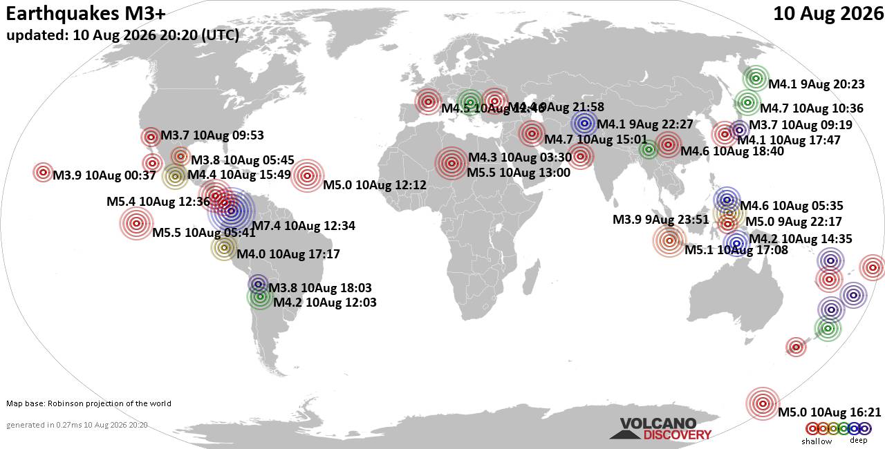
World Earthquake Report for Monday, 10 August 2026
• Volcano earthquake report for Monday, 10 Aug 2026
• Moderate mag. 4.0 earthquake - Zangilan Rayon, 58 km southwest of Ganja, Ga...
• Moderate mag. 4.6 earthquake - 31 km northeast of Xunchang, Sichuan, China,...
• Moderate mag. 4.2 earthquake - New Zealand on Tuesday, Aug 11, 2026, at 06:...
• World Earthquake Report for August 2026
|
|
|
Joined: Feb 2001
Posts: 678,976
Launch Director
|
OP

Launch Director
Joined: Feb 2001
Posts: 678,976 |
Issued at 500 AM HST Fri Aug 14 2026 000
WTPA42 PHFO 141444
TCDCP2
Tropical Storm Lala Discussion Number 9
NWS Central Pacific Hurricane Center Honolulu HI CP012026
Issued by NWS National Hurricane Center Miami FL
500 AM HST Fri Aug 14 2026
Lala has remained relatively steady state overnight. The storm
continues to be asymmetric, with most of the deep convection and
tropical-storm-force winds on its north side. Earlier data from an
Air Force reconnaissance aircraft indicate that the minimum pressure
has been generally unchanged around 997 mb and the maximum winds
still near 50 kt. The aircraft data and an OSCAT pass from around
09Z indicate that the wind field has contracted, which could be a
sign that circulation is becoming more compact and might lead to
strengthening soon.
Lala is moving west-northwestward at 10 kt, and this general motion
is expected to persist during the next few days as a mid-level high
pressure system remains anchored north of the Hawaiian Islands. This
motion should take the core of Lala very near or over the Big Island
on Saturday. When Lala is near the Big Island, short-term
deviations in the track are also likely due to local terrain
interactions, as depicted in many of the models. After Lala passes
the Big Island, a continued west-northwestward track south of the
remainder of the islands is expected Saturday night and Sunday. The
NHC track forecast is mostly unchanged from the previous one, and is
based on a blend of the latest Google DeepMind, HCCA, and TVCA aids,
which have been performing quite well for this storm.
Steady strengthening is expected during the next day or so since the
storm appears to be consolidating while environmental conditions
remain generally favorable. Lala is still forecast to become a
category 1 hurricane when it reaches the Big Island. Land
interaction and an increase in wind shear should result in Lala
weakening back to a tropical storm as it moves south of the
remainder of the island chain later in the weekend.
Re-strengthening is forecast early next week as vertical wind shear
relaxes and Lala remains over warm sea surface temperatures. The
latest NHC intensity forecast is similar to the previous advisory
and remains near the upper end of the guidance envelope.
Key Messages:
1. Lala is forecast to strengthen and become a hurricane as it
approaches the Big Island of Hawaii on Saturday. A Hurricane Warning
remains in effect for the Big Island and a Tropical Storm Warning
has been issued for Maui County. Tropical Storm Watches have been
issued for Oahu and Kauai Counties. Winds are expected to be the
strongest in areas of higher terrain.
2. Heavy rainfall associated with Tropical Storm Lala will begin to
impact the Big Island today, spreading westward across the
remainder of the island chain during the weekend. This rainfall may
produce life-threatening flooding and mudslides, especially in areas
of steep terrain.
3. Large and dangerous waves, especially on the Big Island, are
expected this weekend, with the greatest impacts along exposed
windward and southern shores. This prolonged period of heavy surf
may cause localized coastal flooding and significant beach erosion.
FORECAST POSITIONS AND MAX WINDS
INIT 14/1500Z 16.7N 149.5W 50 KT 60 MPH
12H 15/0000Z 17.2N 151.2W 55 KT 65 MPH
24H 15/1200Z 18.0N 153.3W 65 KT 75 MPH
36H 16/0000Z 18.7N 155.2W 65 KT 75 MPH
48H 16/1200Z 19.6N 158.0W 60 KT 70 MPH
60H 17/0000Z 20.2N 160.4W 60 KT 70 MPH
72H 17/1200Z 20.7N 163.0W 60 KT 70 MPH
96H 18/1200Z 21.2N 166.9W 65 KT 75 MPH
120H 19/1200Z 22.3N 170.9W 70 KT 80 MPH
$$
Forecaster Cangialosi/Pierce Source: Tropical Storm Lala Forecast Discussion Number 9
|
|



CMS The Best Conveyancing solicitors conveyancing quotes throughout the UK
For any webhosting enquiries please email webmaster@aus-city.com
|
|
Forums60
Topics796,370
Posts831,160
Members2,960
| |
Most Online102,106
Jul 10th, 2026
|
|
|





































