|
0 members (),
1,260
guests, and
16
robots. |
|
Key:
Admin,
Global Mod,
Mod
|
|
S |
M |
T |
W |
T |
F |
S |
|
|
|
|
|
|
|
1
|
|
2
|
3
|
4
|
5
|
6
|
7
|
8
|
|
9
|
10
|
11
|
12
|
13
|
14
|
15
|
|
16
|
17
|
18
|
19
|
20
|
21
|
22
|
|
23
|
24
|
25
|
26
|
27
|
28
|
29
|
|
30
|
31
|
|
|
|
|
|
|
There are no members with birthdays on this day. |

Volcano earthquake report for Sunday, 16 Aug 2026
• World Earthquake Report for Sunday, 16 August 2026
• World Earthquake Report for Sunday, 16 August 2026
• Seismic-like event, possible earthquake, reported few minutes ago near Gran...
• Seismic-like event, possible earthquake, reported few minutes ago near Gran...
|
|
|
Joined: Feb 2001
Posts: 678,976
Launch Director
|
OP

Launch Director
Joined: Feb 2001
Posts: 678,976 |
SPC MD 1999MD 1999 CONCERNING SEVERE POTENTIAL...WATCH UNLIKELY FOR PORTIONS OF THE BLACK HILLS IN SOUTHWESTERN SOUTH DAKOTA INTO FAR NORTHERN NEBRASKA 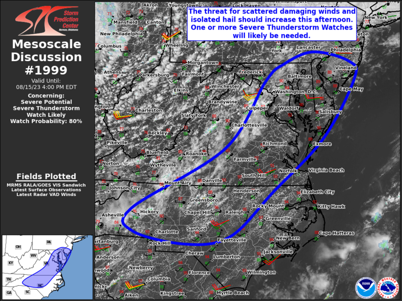
Mesoscale Discussion 1999
NWS Storm Prediction Center Norman OK
0203 PM CDT Sun Aug 16 2026

Areas affected...portions of the Black Hills in southwestern South
Dakota into far northern Nebraska

Concerning...Severe potential...Watch unlikely

Valid 161903Z - 162100Z

Probability of Watch Issuance...20 percent

SUMMARY...Isolated thunderstorms are forecast to evolve
southeastward out of the Black Hills through this evening. The
primary hazards will be isolated large hail and damaging wind gusts.

DISCUSSION...Convective development is ongoing across portions the
Black Hills in southwestern South Dakota and adjacent areas of
Montana/Wyoming. Expectation is for at least an isolated
thunderstorm or two to eventually evolve southeastward out of the
Black Hills. While available buoyancy remains weak as of 1900 UTC,
further insolation should result in additional destabilization
through the afternoon to around 1000-1500 J/kg MLCAPE. Effective
shear of 30-40 kts and steepening mid-level lapse rates may promote
a supercell or two capable of isolated large hail, with steep
low-level lapse rates and the possibility of eventual clustering
also supporting a risk for occasional damaging/severe wind gusts.
Current expectations are for thunderstorm/severe coverage to remain
too isolated for watch issuance; however, a targeted Severe
Thunderstorm Watch could be considered should convective
coverage/severe risk trend greater than anticipated.

..Chalmers/Guyer.. 08/16/2026

...Please see www.spc.noaa.gov for graphic product...

ATTN...WFO...LBF...UNR...

LAT...LON   42840195 43010273 43410329 43900377 44210398 44500403
            44680385 44650321 44340258 43720168 43490148 43210137
            43050144 42890164 42840195

MOST PROBABLE PEAK WIND GUST...55-70 MPH
MOST PROBABLE PEAK HAIL SIZE...1.00-1.75 IN
Read morehttps://www.spc.noaa.gov/products/md/md1999.html
|
|



CMS The Best Conveyancing solicitors conveyancing quotes throughout the UK
For any webhosting enquiries please email webmaster@aus-city.com
|
|
Forums60
Topics797,168
Posts831,958
Members2,960
| |
Most Online102,106
Jul 10th, 2026
|
|
|





































