|
|
|
0 members (),
1,183
guests, and
24
robots. |
|
Key:
Admin,
Global Mod,
Mod
|
|
S |
M |
T |
W |
T |
F |
S |
|
|
|
1
|
2
|
3
|
4
|
5
|
|
6
|
7
|
8
|
9
|
10
|
11
|
12
|
|
13
|
14
|
15
|
16
|
17
|
18
|
19
|
|
20
|
21
|
22
|
23
|
24
|
25
|
26
|
|
27
|
28
|
29
|
30
|
|
|
|
|
There are no members with birthdays on this day. |
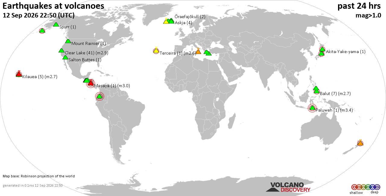
Volcano earthquake report for Saturday, 12 September 2026
• World Earthquake Report for Saturday, 12 September 2026
• Moderate but deep magnitude 5.3 quake hits 74 km southeast of Nakanoshima, ...
• Strong mag. 5.3 earthquake - Ryukyu Islands, Japan, on Sunday, Sep 13, 2026...
• Seismic-like event, possible earthquake, reported minutes ago near Pasto, N...
• Moderate mag. 4.3 earthquake - Philippine Sea, 34 km south of Miyake, Tokyo...
|

#854167
Wed 02 Sep 2026 01:02:AM
|
Joined: Feb 2001
Posts: 678,977
Launch Director
|
|
Launch Director
Joined: Feb 2001
Posts: 678,977 |
SPC Sep 2, 2026 0100 UTC Day 1 Convective OutlookSPC 0100Z Day 1 Outlook 
Day 1 Convective Outlook
NWS Storm Prediction Center Norman OK
0759 PM CDT Tue Sep 01 2026

Valid 020100Z - 021200Z

...THERE IS A SLIGHT RISK OF SEVERE THUNDERSTORMS ACROSS PORTIONS OF
THE CENTRAL PLAINS AND MIDWEST AS WELL AS THE MID ATLANTIC...

...SUMMARY...
Scattered strong to severe thunderstorms remain likely into tonight
across parts of the northern/central Plains and Upper Midwest, and
parts of southern New York into the Mid-Atlantic. Large hail and
damaging winds should be the main threats.

...Southern NY/The Mid Atlantic...
A mid-level shortwave trough and enhanced west-northwesterly flow
were observed from the Northeast/Mid Atlantic States to the lower
Great Lakes this evening. A front was draped from northwest to
southeast across southern NY/New England, with numerous showers and
storms ongoing along and south of it this evening. The air mass here
is unstable and moderately sheared which is supporting organized
supercells and short linear segments. Damaging gusts remain likely
through this evening, along with some hail and perhaps a brief
tornado, especially near the from across southeastern PA and NJ
where low-level sear is maximized. Convection should eventually
begin to weaken with the loss of diurnal heating and as it
approaches the coast later this evening.

...Central Plains and Midwest...
Several supercells have developed ahead of a weak surface low along
a stalled front from NE into SD. A very unstable air mass (MLCAPE of
3000+ J/kg) is in place and extended downstream of the cluster
across eastern SD, northern IA and southern MN. A belt of strong
mid-level westerly flow along the front will continue to support
organized storms. Upscale growth is possible this evening with one
or more clusters or an MCS expected to eventually develop and track
across portions of northern IA and far southern MN. This will pose a
threat for severe wind gusts and perhaps a tornado along the front
through tonight.

Farther southwest along the surface lee trough, scattered high-based
storms were ongoing in eastern CO and western KS. Buoyancy and shear
are much weaker, but steep lapse rates and T/TD spread of 30-40
degrees could support a sporadic severe gusts with these storms
before they weaken near sunset.

...Great Lakes...
A secondary mid-level vort max and upper low, currently over the
western Great lakes, may serve as a focus for additional storm
development tonight across eastern WI and lower MI. The eastern
portions of the quasi stationary front remain very warm and
unstable. As ascent from the upper low/shortwave approach after
midnight, they may support a modest enhancement of the southwestern
low-level jet. Warm advection at the nose of this feature could
allow for a cluster of thunderstorms to develop and intensify. The
large elevated buoyancy and 40-50 kt westerly flow would favor a
risk for hail and damaging gusts before moving into southern ON by
12z Wed. However, confidence in how this scenario evolves remains
low and only 5% wind/hail probabilities will be maintained given the
uncertainty in storm development.

...Coastal Southeast Texas/Southwest Louisiana...
Tropical Storm Edouard will continue tracking northwestward across
southeast TX and southwest LA per latest NHC forecasts. Some
enhancement to the low-level wind field and hodographs has been
noted in outer bands along the northern portions of the circulation.
This may support transient updraft rotation with any cells. A brief
tornado or two may occur across parts of coastal southeast
TX/southwest LA through tonight as the system weakens.

..Lyons.. 09/02/2026
Read morehttps://www.spc.noaa.gov/products/outlook/day1otlk_0100.html
|
|



CMS The Best Conveyancing solicitors conveyancing quotes throughout the UK
For any webhosting enquiries please email webmaster@aus-city.com
|
|
Forums60
Topics825,940
Posts860,733
Members2,960
| |
Most Online102,106
Jul 10th, 2026
|
|
|
|
|

|





































