|
|
|
0 members (),
1,384
guests, and
27
robots. |
|
Key:
Admin,
Global Mod,
Mod
|
|
S |
M |
T |
W |
T |
F |
S |
|
|
|
|
|
1
|
2
|
3
|
|
4
|
5
|
6
|
7
|
8
|
9
|
10
|
|
11
|
12
|
13
|
14
|
15
|
16
|
17
|
|
18
|
19
|
20
|
21
|
22
|
23
|
24
|
|
25
|
26
|
27
|
28
|
29
|
30
|
31
|
|
There are no members with birthdays on this day. |
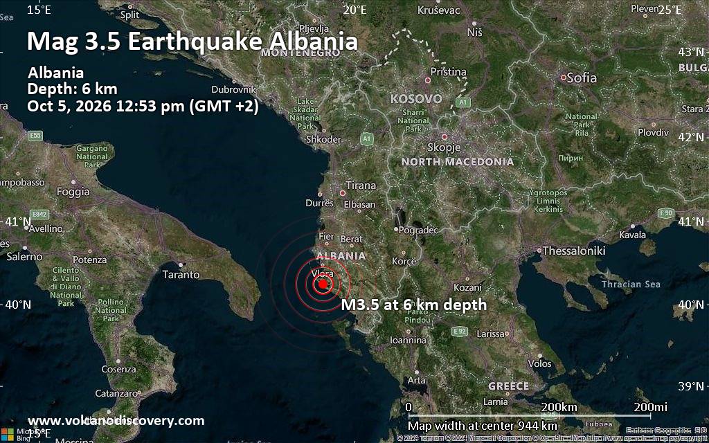
Magnitude 3.5 earthquake strikes near Vlore, Bashkia Vlorë, Qarku i Vlores, Albania
• World Earthquake Report for Monday, 5 October 2026
• M 5.5 - Volcano Islands, Japan region
• M 1.9 - 15 km ESE of Pearsall, Texas
• M 0.8 - 5 km SSW of Redlands, CA
• M 3.0 - 50 km WNW of Ninilchik, Alaska
|

#856871
Sat 05 Sep 2026 07:47:AM
|
Joined: Feb 2001
Posts: 678,977
Launch Director
|
|
Launch Director
Joined: Feb 2001
Posts: 678,977 |
SPC Sep 5, 2026 Day 4-8 Severe Weather OutlookDay 4-8 Outlook 
Day 4-8 Convective Outlook
NWS Storm Prediction Center Norman OK
0244 AM CDT Sat Sep 05 2026

Valid 081200Z - 131200Z

...DISCUSSION...
...Days 4-6/Tue-Thu -- Central Plains to Great Lakes/Ohio Valley and
Mid-Atlantic...

An upper shortwave trough will shift east across the Upper
Midwest/Great Lakes and northeast through Thursday. An associated
surface low will mainly remain over Canada, but a trailing cold
front will sweep across parts of the central Plains and Upper
Midwest on Tuesday, before continuing south and east into Kansas and
across the Great Lakes on Wednesday. By Thursday, the boundary is
expected to continue south and east across the Ohio Valley and
Mid-Atlantic. Stronger large-scale ascent will likely remain focused
near and north of the international border. Furthermore, the
corridor of deeper boundary layer moisture may be somewhat limited,
especially Tuesday into Wednesday, due to a prior cold frontal
passage and surface high pressure over the Midwest. Nevertheless,
enhanced deep-layer flow, and corridors of at least modest
instability along the cold front could support some severe risk.
However, confidence in 15 percent or greater coverage is low at this
time frame.

...Days 7-8/Fri-Sat -- Northern/Central Plains to Upper Midwest...

At the end of the period, another upper shortwave trough may dig
southeast from the Pacific Northwest and into the Plains. Another,
perhaps stronger, cold front could sweep across the Plains and the
Mid/Upper MS Valley. Depending on moisture return in the wake of the
earlier cold frontal passage, some severe risk could develop during
the weekend. Furthermore, large spread exists among various guidance
regarding the evolution of the this upper trough, resulting in
uncertainty in greater corridors of severe potential.
Read morehttps://www.spc.noaa.gov/products/exper/day4-8/
|
|



CMS The Best Conveyancing solicitors conveyancing quotes throughout the UK
For any webhosting enquiries please email webmaster@aus-city.com
|
|
Forums60
Topics857,582
Posts892,377
Members2,960
| |
Most Online102,106
Jul 10th, 2026
|
|
|
|
|

|









































