|
|
|
0 members (),
1,096
guests, and
26
robots. |
|
Key:
Admin,
Global Mod,
Mod
|
|
S |
M |
T |
W |
T |
F |
S |
|
|
|
1
|
2
|
3
|
4
|
5
|
|
6
|
7
|
8
|
9
|
10
|
11
|
12
|
|
13
|
14
|
15
|
16
|
17
|
18
|
19
|
|
20
|
21
|
22
|
23
|
24
|
25
|
26
|
|
27
|
28
|
29
|
30
|
|
|
|
|
There are no members with birthdays on this day. |
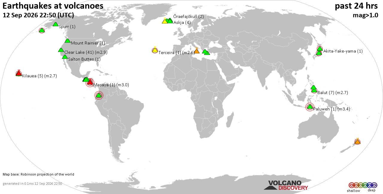
Volcano earthquake report for Saturday, 12 September 2026
• World Earthquake Report for Saturday, 12 September 2026
• Moderate but deep magnitude 5.3 quake hits 74 km southeast of Nakanoshima, ...
• Strong mag. 5.3 earthquake - Ryukyu Islands, Japan, on Sunday, Sep 13, 2026...
• Seismic-like event, possible earthquake, reported minutes ago near Pasto, N...
• Moderate mag. 4.3 earthquake - Philippine Sea, 34 km south of Miyake, Tokyo...
|
|
|
Joined: Feb 2001
Posts: 678,977
Launch Director
|
|
Launch Director
Joined: Feb 2001
Posts: 678,977 |
SPC Sep 12, 2026 1930 UTC Day 3 Severe Thunderstorm OutlookSPC 1930Z Day 3 Outlook 
Day 3 Convective Outlook
NWS Storm Prediction Center Norman OK
0212 PM CDT Sat Sep 12 2026

Valid 141200Z - 151200Z

...THERE IS A SLIGHT RISK OF SEVERE THUNDERSTORMS ACROSS PORTIONS OF
EASTERN NEBRASKA INTO WESTERN IOWA...

...SUMMARY...
Strong thunderstorm development, accompanied by at least some risk
for severe weather, appears possible across parts of the central
Great Plains into Upper Midwest late Monday through Monday night.

...Discussion...
A mid-level trough will move across the northern Plains on Monday
with a strengthening 60-70 knot mid-level jet streak. The surface
pattern will feature a surface low across the Canadian Prairies and
a secondary weaker surface low across the central Plains. A moist
airmass will advect northward to the east of the surface trough with
mid to upper 60s dewpoints advecting into Nebraska and Iowa.

Thunderstorms will likely be ongoing at the beginning of the period
across eastern South Dakota and Minnesota amid moderate isentropic
ascent. The primary forecast concern for Monday will be northward
progression of the surface boundary across eastern Nebraska and
Iowa. Guidance varies with the northward recovery in the wake of
morning activity, but forecast soundings in regions where this
recovery does occur show a conditional supercell environment with
the threat for all severe weather hazards.

Given the influence of morning convection, the exact location of the
greatest threat will likely shift in the coming days. However, given
that most guidance showed a convective signal aligned with a
conditionally favorable supercell environment in the vicinity of
eastern Nebraska and western Iowa, added a small Slight Risk across
this region to account for this threat.

An elevated hail threat may persist into Monday evening farther
northeast given a strong low-level jet and moderate elevated
instability. Some surface based storm threat could continue into the
overnight hours along the boundary, but most guidance shows storms
north of the boundary during the overnight period.

Storms will likely form within the well-mixed environment across
eastern Colorado and western Kansas Monday afternoon. Weak shear
should limit storm organization, but strong heating and steep lapse
rates may support isolated severe wind gusts.

..Bentley.. 09/12/2026
Read morehttps://www.spc.noaa.gov/products/outlook/day3otlk_1930.html
|
|



CMS The Best Conveyancing solicitors conveyancing quotes throughout the UK
For any webhosting enquiries please email webmaster@aus-city.com
|
|
Forums60
Topics825,486
Posts860,279
Members2,960
| |
Most Online102,106
Jul 10th, 2026
|
|
|
|
|

|





































