|
|
|
0 members (),
2,565
guests, and
25
robots. |
|
Key:
Admin,
Global Mod,
Mod
|
|
S |
M |
T |
W |
T |
F |
S |
|
|
|
1
|
2
|
3
|
4
|
5
|
|
6
|
7
|
8
|
9
|
10
|
11
|
12
|
|
13
|
14
|
15
|
16
|
17
|
18
|
19
|
|
20
|
21
|
22
|
23
|
24
|
25
|
26
|
|
27
|
28
|
29
|
30
|
|
|
|
|
There are no members with birthdays on this day. |

Small magnitude 3.6 earthquake strikes near Great Falls, Cascade County, Montana, USA
• Volcano earthquake report for Friday, 18 September 2026
• Possible earthquake reported minutes ago near Great Falls, Montana, USA
• Magnitude 4.6 earthquake strikes near Ponce, Segundo Barrio, Ponce Municipi...
• Small magnitude 3.4 earthquake strikes near Skegness, Lincolnshire, England...
• World Earthquake Report for Friday, 18 September 2026
|

#865950
Wed 16 Sep 2026 02:40:PM
|
Joined: Feb 2001
Posts: 678,977
Launch Director
|
|
Launch Director
Joined: Feb 2001
Posts: 678,977 |
Magnitude 3.7 earthquake strikes near Eureka, Humboldt County, California, USA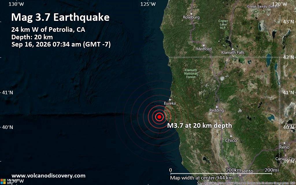 Just 4 minutes ago, a magnitude 3.7 earthquake struck near Eureka, Humboldt County, California, USA. The tremor was recorded on the morning of Wednesday, September 16th, 2026, at 7:34 am local time, at a shallow depth of 13 miles below the surface.
The event was reported by the United States Geological Survey, the first seismological agency to report it.
A second report was later issued by the European-Mediterranean Seismological Centre (EMSC), which listed it as a magnitude 3.6 earthquake.
Towns or cities near the epicenter where the quake might have been felt as very weak shaking include Ferndale (pop. 1,400), located 25 miles from the epicenter; Rio Dell (pop. 3,400), 28 miles away; Fortuna (pop. 12,000), 30 miles away; Hydesville (pop. 1,200), 30 miles away; Humboldt Hill (pop. 3,400), 36 miles away; and Eureka (pop. 27,000), 41 miles away. In Bayside (pop. 17,100, 46 miles away), Arcata (pop. 17,800, 47 miles away), and McKinleyville (pop. 15,200, 51 miles away), the quake was probably not felt.
Earthquake data: Date & time: Sep 16, 2026 07:34 am (GMT -7) local time (16 Sep 2026 14:34 GMT)Magnitude: 3.7 Hypocenter depth: 20.23 km Epicenter coordinates: 40.3°N / 124.57°W  ( Humboldt County, California, United States) Primary data source: USGShttps://www.volcanodiscovery.com/earthquakes/news/356353/Magnitude-37-earthquake-strikes-near-Eureka-Humboldt-County-California-USA.html
|
|



CMS The Best Conveyancing solicitors conveyancing quotes throughout the UK
For any webhosting enquiries please email webmaster@aus-city.com
|
|
Forums60
Topics830,595
Posts865,390
Members2,960
| |
Most Online102,106
Jul 10th, 2026
|
|
|
|
|

|





































