|
|
|
1 members (Alisa),
1,769
guests, and
28
robots. |
|
Key:
Admin,
Global Mod,
Mod
|
|
S |
M |
T |
W |
T |
F |
S |
|
|
|
|
|
1
|
2
|
3
|
|
4
|
5
|
6
|
7
|
8
|
9
|
10
|
|
11
|
12
|
13
|
14
|
15
|
16
|
17
|
|
18
|
19
|
20
|
21
|
22
|
23
|
24
|
|
25
|
26
|
27
|
28
|
29
|
30
|
31
|
|
There are no members with birthdays on this day. |
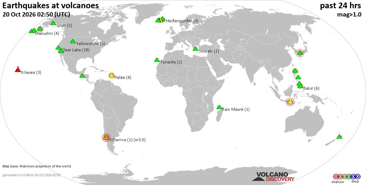
Volcano earthquake report for Tuesday, 20 October 2026
• Moderate mag. 4.0 earthquake - South OF Sumbawa, Indonesia, on Tuesday, Oct...
• M 1.6 - 6 km NE of Aguanga, CA
• M 1.5 - 21 km S of Lindsay, Texas
• M 2.6 - 18 km SSW of Jal, New Mexico
• M 2.0 - 19 km ESE of Naalehu, Hawaii
|

#880287
Mon 28 Sep 2026 12:50:AM
|
Joined: Feb 2001
Posts: 678,977
Launch Director
|
|
Launch Director
Joined: Feb 2001
Posts: 678,977 |
Volcano earthquake report for Monday, 28 September 2026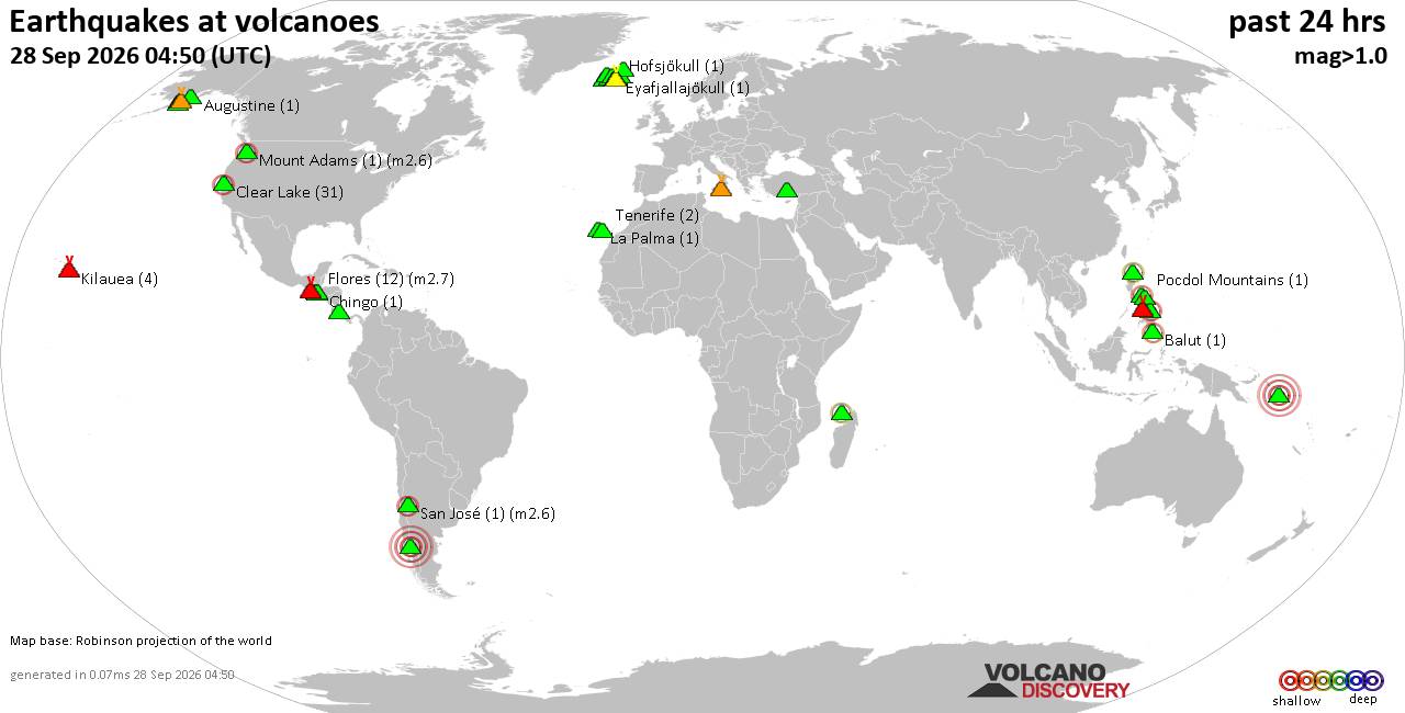 World map showing volcanoes with shallow (less than 50 km) earthquakes within 20 km radius during the past 24 hours on 28 Sep 2026 Number in brackets indicate nr of quakes. Quakes detected near: Alaska Peninsula Arc at 155.4°W (2 quakes between mag 1.2-1.6), Augustine (1 quake mag 1.1), Balut (2 quakes between mag 2.1-2.3), Cabalian (2 quakes between mag 2.3-3.1), Camiguin de Babuyanes (1 quake mag 2.0), Clear Lake (30 quakes between mag 0.3-2.0)
Corcovado (1 quake mag 4.4), Eldey (2 quakes between mag 1.1-1.3), Etna (2 quakes between mag 0.5-1.2), Eyafjallajökull (1 quake mag 1.5), Fani Maoré (1 quake mag 2.0), Flores (15 quakes between mag 1.1-2.7), Gran Canaria (1 quake mag 1.0), Hofsjökull (1 quake mag 1.3), Hrómundartindur (12 quakes between mag 0.0-1.1), Irazu (1 quake mag 1.2), Kanlaon (4 quakes between mag 1.8-2.8), Karadağ (3 quakes between mag 1.5-2.1), Katla (9 quakes between mag 0.0-1.1), Katmai (3 quakes between mag 0.7-1.1), Kilauea (4 quakes between mag 1.0-1.8), La Palma (1 quake mag 1.3), Loki-Fögrufjöll volcano (3 quakes between mag 0.5-1.0), Mahagnao (1 quake mag 2.0), Mount Adams (1 quake mag 2.6), New Georgia at 8.9°S (1 quake mag 4.9), Novarupta (5 quakes between mag 0.8-1.8), Pocdol Mountains (1 quake mag 1.5), Prestahnukur (2 quakes between mag 1.2-1.7), Rinjani (1 quake mag 2.7), San José (1 quake mag 2.6), Sousaki (1 quake mag 1.7), Tenerife (2 quakes between mag 0.4-1.4), Tindfjallajökull (3 quakes between mag 0.0-1.9), Tjörnes Fracture Zone (5 quakes between mag 0.0-2.1), Torfajökull (69 quakes between mag 0.0-2.0) (updated 00h50)\n\nNote: Earthquakes within 20 km from and at depths less than 50 km under active volcanoes are reported. The list is not complete because many volcanoes are not monitored and/or seismic data in high resolution is not available publicly.\n
Volcanoes with recent earthquakes above magnitude 2 or more than 10 quakes are listed below:
Balut volcano (Mindanao): 2 earthquakes up to magnitude 2.32 earthquakes occurred near (under) the volcano during 18 hours, the last being recorded quake 6 hours ago. Hypocenter depths ranged between 19.00 and 15.00 km. Earthquake details: 2.3 quake 016 km N 42° W of Balut Island (Municipality of Sarangani) (Davao Occidental) Sep 27, 2026 08:54 am (GMT +8) (14 km NNW) 2.1 quake Philippines: 012 km S 57° W of Balut Island (Municipality of Sarangani) (Davao Occidental) Sep 28, 2026 02:58 am (GMT +8) (7 km SW) All earthquakes at BalutBalut is an 840 m island stratovolcano south of Mindanao whose last known eruption occurred between about 2 million and 11,700 years ago. Hot springs and thermally altered ground occur on its western and southwestern flanks. Cabalian volcano (Central Philippines): 2 earthquakes up to magnitude 3.12 earthquakes occurred near (under) the volcano during 2 hours, the last being recorded quake 15 hours ago. Hypocenter depths ranged between 7.00 and 4.00 km. Earthquake details: 3.1 quake Leyte, Philippines, Sep 27, 2026 03:21 pm (GMT +8) (15 km NNE) 2.3 quake 000 km N 45° W of San Juan (Southern Leyte) Sep 27, 2026 05:40 pm (GMT +8) (6 km WSW) All earthquakes at CabalianCabalían is a 912 m-high stratovolcano on southeastern Leyte, distinguished by its lake-filled summit crater. Radiocarbon evidence records an eruption around 1820, with an uncertainty of about 30 years. Clear Lake volcano (California): 30 earthquakes up to magnitude 2.0Possible earthquake swarm: 30 earthquakes occurred near (under) the volcano during 20 hours, the last being recorded quake 35 minutes ago. Hypocenter depths ranged between 3.61 and 0.26 km. Earthquake details: (only 5 largest) 2.0 quake 7 km W of Cobb, CA, Sep 27, 2026 01:34 am (GMT -7) (15 km S) 1.5 quake 8 km NW of the Geysers, CA, Sep 27, 2026 02:22 pm (GMT -7) (16 km SSW) 1.5 quake 7 km W of Cobb, CA, Sep 27, 2026 01:34 am (GMT -7) (16 km S) 1.4 quake 3 km W of Cobb, CA, Sep 27, 2026 01:05 pm (GMT -7) (16 km S) 1.3 quake 7 km WNW of Cobb, CA, Sep 27, 2026 05:33 am (GMT -7) (15 km S) All earthquakes at Clear LakeCorcovado volcano (Southern Chile and Argentina): magnitude 4.4 earthquakeA magnitude 4.4 earthquake occurred at the volcano 6 hours ago. The quake, which might be volcanic in origin, was located at a depth of 10.00 km depth at 18 km distance NE from the volcano. Earthquake details: 4.4 quake 20 km SSE of Chaitén, Chile, Sep 27, 2026 03:55 pm (Santiago time) (18 km NE) All earthquakes at CorcovadoCorcovado is an isolated, glacier-eroded stratovolcano in Chile, surrounded by younger cinder cones. Three prehistoric eruptions are confirmed, while reports of activity in 1834 and 1835 are uncertain. Flores volcano (Guatemala): 15 earthquakes up to magnitude 2.7Possible earthquake swarm: 15 earthquakes occurred near (under) the volcano during 17 hours, the last being recorded quake 6 hours ago. Hypocenter depths ranged between 15.20 and 3.00 km. Earthquake details: (only 5 largest) 2.7 quake Guatemala Sep 27, 2026 12:28 pm (GMT -6) (14 km WNW) 2.6 quake Guatemala Sep 27, 2026 06:28 am (GMT -6) (14 km WNW) 2.3 quake Guatemala Sep 26, 2026 06:58 pm (GMT -6) (14 km WNW) 1.6 quake Guatemala Sep 27, 2026 09:19 am (GMT -6) (15 km WNW) 1.6 quake Guatemala Sep 27, 2026 09:10 am (GMT -6) (15 km WNW) All earthquakes at FloresFlores, also known as Volcán Amayo, is a volcanic field about 10 km west of Jutiapa in southeastern Guatemala. Its last eruption is undated, and none are known from approximately the past 11,700 years. Hrómundartindur volcano (Iceland): 12 earthquakes up to magnitude 1.1Possible earthquake swarm: 12 earthquakes occurred near (under) the volcano during 21 hours, the last being recorded quake 1 hour 12 minutes ago. Hypocenter depths ranged between 9.90 and 0.00 km. Earthquake details: (only 5 largest) 1.1 quake 1.4 km ESE of Raufarhólshellir Sep 27, 2026 12:58 pm (Universal Time) (16 km S) 0.8 quake Iceland: 1.5 km W of Skálafell Sep 27, 2026 08:52 pm (Reykjavik time) (10 km S) 0.8 quake 6.6 km SSE of Skálafell Sep 27, 2026 07:48 am (Universal Time) (15 km SSE) 0.8 quake 3.6 km NE of Hellisheiðarvirkjun Sep 27, 2026 03:29 am (Universal Time) (3 km SSW) 0.7 quake Iceland: 3.4 km NE of Hellisheiðarvirkjun Sep 27, 2026 03:29 am (Reykjavik time) (3 km SSW) All earthquakes at HrómundartindurHrómundartindur is a small volcanic system in southwestern Iceland with an active geothermal area at Ölkeduháls. Its last eruption is uncertain, but activity is thought to have occurred about 10,000 years ago. Kanlaon volcano (Central Philippines): 4 earthquakes up to magnitude 2.84 earthquakes occurred near (under) the volcano during 12 hours, the last being recorded quake 8 hours ago. Hypocenter depths ranged between 11.00 and 4.00 km. Earthquake details: 2.8 quake Philippines: 007 km S 72° E of Moises Padilla (Negros Occidental) Sep 28, 2026 12:45 am (GMT +8) (18 km S) 2.8 quake Cebu, Philippines, Sep 27, 2026 12:45 pm (GMT +8) (18 km S) 2.4 quake 008 km N 13 W of City of Canlaon (Negros Oriental) Sep 27, 2026 10:36 pm (GMT +8) (9 km NE) 1.8 quake 005 km N 72° E of Moises Padilla (Negros Occidental) Sep 27, 2026 01:16 pm (GMT +8) (14 km S) All earthquakes at KanlaonKanlaon is a 2,422-m-high stratovolcano and the highest point on the Philippine island of Negros. Its frequently explosive historical activity includes a deadly 1996 eruption and stronger eruptions during 2024-26. Karadağ volcano (Turkey): 3 earthquakes up to magnitude 2.13 earthquakes occurred near (under) the volcano during 18 minutes, the last being recorded quake 33 minutes ago. Hypocenter depths ranged between 9.80 and 6.90 km. Earthquake details: 2.1 quake Central Turkey Sep 28, 2026 02:59 am (GMT +3) (12 km ESE) 1.8 quake Central Turkey Sep 28, 2026 03:10 am (Istanbul time) (12 km ESE) 1.5 quake Turkey: Beydili-(karaman) Sep 28, 2026 03:17 am (Istanbul time) (15 km ESE) All earthquakes at KaradağMount Adams volcano (Washington State): magnitude 2.6 earthquakeA magnitude 2.6 earthquake occurred at the volcano 38 minutes ago. The quake, which might be volcanic in origin, was located at a depth of 2.27 km depth at 3 km distance W from the volcano. Earthquake details: 2.6 quake 23 km N of Trout Lake, Washington, Sep 27, 2026 05:12 pm (GMT -7) (3 km W) All earthquakes at Mount AdamsMount Adams is a large stratovolcano in south-central Washington with more than 60 flank vents. Its last known eruption occurred around 950 CE, producing minor tephra and possibly a small east-flank lava flow. New Georgia at 8.9°S volcano (Solomon Islands): magnitude 4.9 earthquakeA magnitude 4.9 earthquake occurred at the volcano 20 hours ago. The quake, which might be volcanic in origin, was located at a depth of 10.00 km depth at 4 km distance NE from the volcano. Earthquake details: 4.9 quake 159 km ESE of Gizo, Solomon Islands, Sep 27, 2026 03:59 pm (Guadalcanal time) (4 km NE) All earthquakes at New Georgia at 8.9°SRinjani volcano (Lombok): magnitude 2.7 earthquakeA magnitude 2.7 earthquake occurred at the volcano 24 hours ago. The quake, which might be volcanic in origin, was located at a depth of 10.00 km depth at 8 km distance NNW from the volcano. Earthquake details: 2.7 quake Sumbawa Region, Indonesia, Sep 27, 2026 09:12 am (GMT +8) (8 km NNW) All earthquakes at RinjaniRinjani is a 3,726-m stratovolcano on Lombok whose large caldera formed during the enormous 1257 eruption of Samalas. Recorded activity since the mid-19th century has occurred at Barujari cone within the caldera. San José volcano (Central Chile and Argentina): magnitude 2.6 earthquakeA magnitude 2.6 earthquake occurred at the volcano 17 hours ago. The quake, which might be volcanic in origin, was located at a depth of 8.00 km depth at 19 km distance WSW from the volcano. Earthquake details: 2.6 quake Region Metropolitana, Chile, Sep 27, 2026 05:08 am (GMT -3) (19 km WSW) All earthquakes at San JoséSan José is a stratovolcano complex on the Chile–Argentina border. Seven confirmed eruptive periods are recorded between 1822 and 1960, generally involving small explosions or ash-producing activity. Tjörnes Fracture Zone volcano (Iceland): 5 earthquakes up to magnitude 2.15 earthquakes occurred near (under) the volcano during 17 hours, the last being recorded quake 1 hour 2 minutes ago. Hypocenter depths ranged between 23.50 and 6.40 km. Earthquake details: 2.1 quake Iceland: 32.2 km WNW of Kópasker Sep 27, 2026 07:22 pm (Reykjavik time) (15 km N) 2.1 quake 34.5 km ESE of Grímsey Sep 27, 2026 08:15 am (Universal Time) (14 km NW) 1.6 quake Iceland: 26.2 km WNW of Kópasker Sep 27, 2026 11:47 pm (Reykjavik time) (14 km NNE) 1.1 quake 35.3 km ESE of Grímsey Sep 27, 2026 06:35 am (Universal Time) (14 km NNW) 0.0 quake Iceland: 29.9 km W of Kópasker Sep 27, 2026 10:58 am (Reykjavik time) (4 km N) All earthquakes at Tjörnes Fracture ZoneThe Tjörnes Fracture Zone is an offshore volcanic system north of Iceland. A poorly documented submarine eruption was reported near Manareyjar Island in 1867–1868. Torfajökull volcano (Iceland): 69 earthquakes up to magnitude 2.0Possible earthquake swarm: 69 earthquakes occurred near (under) the volcano during 23 hours, the last being recorded quake 37 minutes ago. Hypocenter depths ranged between 12.40 and 0.00 km. Earthquake details: (only 5 largest) 2.0 quake 10.2 km NNW of Álftavatn Sep 27, 2026 01:08 am (Universal Time) (6 km W) 2.0 quake 10.3 km NNW of Álftavatn Sep 27, 2026 01:08 am (Universal Time) (7 km W) 1.9 quake 10.2 km NNW of Álftavatn Sep 27, 2026 01:44 am (Universal Time) (7 km W) 1.6 quake Iceland: 6.5 km WSW of Landmannalaugar Sep 27, 2026 03:53 am (Reykjavik time) (4 km N) 1.6 quake 10.5 km NNW of Álftavatn Sep 27, 2026 01:44 am (Universal Time) (6 km WNW) All earthquakes at TorfajökullTorfajökull contains Iceland’s largest exposed area of silicic and intermediate volcanism. Ten recorded eruptive periods span about 8,000 years, with the last known eruption in 1477. https://www.volcanodiscovery.com/earthquakes-volcanoes/news/366474/Volcano-earthquake-report-2026-09-28.html
|
|



CMS The Best Conveyancing solicitors conveyancing quotes throughout the UK
For any webhosting enquiries please email webmaster@aus-city.com
|
|
Forums60
Topics884,920
Posts919,717
Members2,960
| |
Most Online102,106
Jul 10th, 2026
|
|
|
|
|

|









































