|
0 members (),
1,475
guests, and
27
robots. |
|
Key:
Admin,
Global Mod,
Mod
|
|
S |
M |
T |
W |
T |
F |
S |
|
|
|
|
|
1
|
2
|
3
|
|
4
|
5
|
6
|
7
|
8
|
9
|
10
|
|
11
|
12
|
13
|
14
|
15
|
16
|
17
|
|
18
|
19
|
20
|
21
|
22
|
23
|
24
|
|
25
|
26
|
27
|
28
|
29
|
30
|
31
|
|
There are no members with birthdays on this day. |
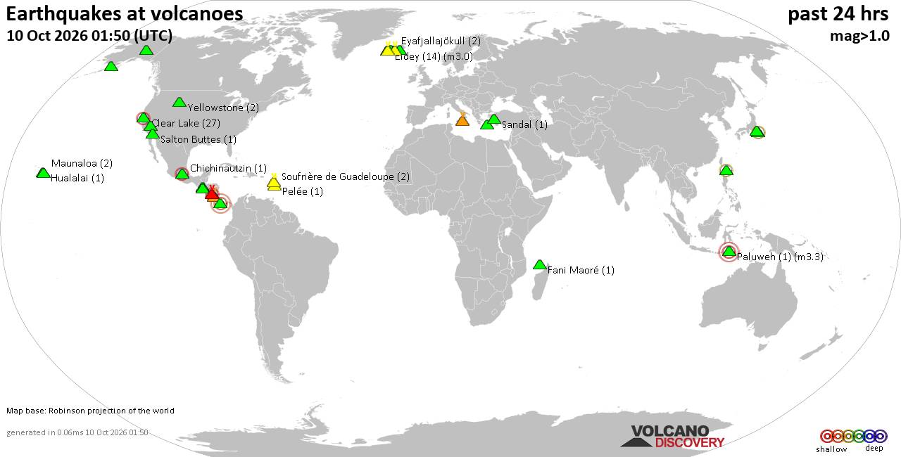
Volcano earthquake report for Saturday, 10 October 2026
• M 3.4 - 31 km NE of Punta Cana, Dominican Republic
• M 4.7 - 2 km WNW of El Cacao, Panama
• M 4.7 - 2 km WNW of El Cacao, Panama
• M 4.7 - 2 km WNW of El Cacao, Panama
• M 4.5 - 103 km SW of Puerto Madero, Mexico
|
|
|
Joined: Feb 2001
Posts: 678,977
Launch Director
|
|
Launch Director
Joined: Feb 2001
Posts: 678,977 |
Issued at 1000 PM CDT Thu Oct 08 2026 000
WTNT44 KNHC 090250
TCDAT4
Hurricane Isaias Discussion Number 10
NWS National Hurricane Center Miami FL AL092026
1000 PM CDT Thu Oct 08 2026
The satellite presentation of Isaias has improved over the past few
hours. Infrared cloud top temperatures have cooled within the
expanding central dense overcast, and recent images show a warm spot
that could be an emerging eye. A series of earlier passive microwave
images showed the mid-level eyewall was open to the southwest, and a
comparison of the AMSR3 89- and 37-GHz channels indicated the vortex
was slightly tilted with height due to continued southwesterly
shear. The stronger Tail Doppler Radar winds noted from the previous
mission indicated the satellite intensity estimates are likely
running too low, and based on the improved structure of the
hurricane, the initial intensity is raised to 90 kt. Air Force and
NOAA Hurricane Hunter aircraft are scheduled to collect data in
Isaias overnight.
Isaias is moving toward the northeast (040/12 kt), but is expected
to turn northward and accelerate on Friday within the flow between
an upper trough near the northwestern Gulf Coast and a subtropical
ridge extending across the western Atlantic. Landfall is expected to
occur within the hurricane warning area Friday night or early
Saturday, with the updated 24-h forecast near the coast. The NHC
forecast continues to lie closer to the right side of the guidance
envelope, very near the latest corrected consensus (HCCA). This
results in little overall change from the previous prediction,
although this forecast is slightly faster based on the model trends
this cycle.
High oceanic heat content and strong upper-level divergence could
allow for additional strengthening overnight while the shear vector
is still oriented in the direction of storm motion. A majority of
Google DeepMind ensemble members show Isaias briefly reaching major
hurricane status early Friday (along with some of the hurricane
regional models), and this is now reflected in the NHC forecast.
This strengthening should be short lived as southwesterly shear from
the aforementioned trough will increase considerably on Friday and
cause some weakening before landfall. Nonetheless, Isaias will be a
dangerous hurricane with significant storm surge, damaging winds,
and flooding rains when it reaches the northern Gulf Coast. During
this time, the wind field is also predicted to grow due to the
trough interaction, and some of these impacts will extend well away
from the center. After landfall, gusty winds are expected to reach
well inland over portions of the southeastern United States.
Key Messages:
1. A life-threatening storm surge is expected from the Mouth of the
Mississippi River to Suwannee, Florida. Residents in the warning
area should follow advice given by local officials and evacuate
immediately if told to do so.
2. Damaging hurricane force-winds are expected over portions of the
Florida Panhandle, southern Alabama, and southern Mississippi where
a Hurricane Warning is in effect. Residents in these areas should
prepare for the possibility of long-duration power outages.
3. Damaging wind gusts are possible over much of central and
northern Alabama, extreme eastern Mississippi, and portions of
western and northern Georgia, especially in areas of higher terrain.
Additional Tropical Storm and High Wind Watches and Warnings may be
required for portions of that area later tonight or on Friday.
Residents should secure loose outdoor items, avoid driving
high-profile vehicles, and prepare for power outages.
4. Isaias will bring areas of heavy rainfall to the central U.S.
Gulf Coast and much of the Southeast Friday into the weekend.
Considerable flash and urban flooding, along with significant river
flooding, will be possible.
FORECAST POSITIONS AND MAX WINDS
INIT 09/0300Z 25.4N 88.4W 90 KT 105 MPH
12H 09/1200Z 27.1N 87.6W 100 KT 115 MPH
24H 10/0000Z 29.9N 87.1W 85 KT 100 MPH
36H 10/1200Z 32.2N 87.3W 45 KT 50 MPH...INLAND
48H 11/0000Z 34.1N 87.5W 30 KT 35 MPH...POST-TROP/INLAND
60H 11/1200Z 36.1N 86.1W 20 KT 25 MPH...POST-TROP/INLAND
72H 12/0000Z 38.0N 83.0W 20 KT 25 MPH...POST-TROP/INLAND
96H 13/0000Z...DISSIPATED
$$
Forecaster Reinhart Source: Hurricane Isaias Forecast Discussion Number 10
|
|



CMS The Best Conveyancing solicitors conveyancing quotes throughout the UK
For any webhosting enquiries please email webmaster@aus-city.com
|
|
Forums60
Topics867,917
Posts902,713
Members2,960
| |
Most Online102,106
Jul 10th, 2026
|
|
|









































