|
0 members (),
1,156
guests, and
26
robots. |
|
Key:
Admin,
Global Mod,
Mod
|
|
S |
M |
T |
W |
T |
F |
S |
|
|
|
|
|
1
|
2
|
3
|
|
4
|
5
|
6
|
7
|
8
|
9
|
10
|
|
11
|
12
|
13
|
14
|
15
|
16
|
17
|
|
18
|
19
|
20
|
21
|
22
|
23
|
24
|
|
25
|
26
|
27
|
28
|
29
|
30
|
31
|
|
There are no members with birthdays on this day. |
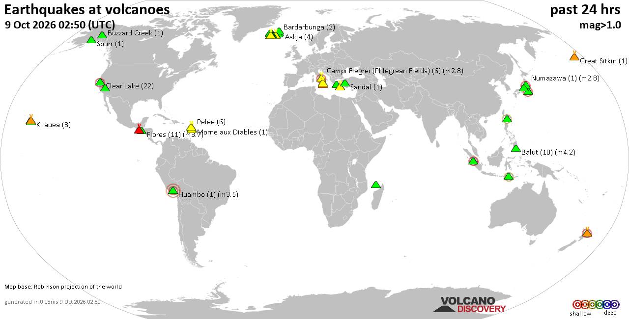
Volcano earthquake report for Friday, 9 October 2026
• Moderate mag. 4.4 earthquake - Kabupaten Mamuju Utara, West Sulawesi, Indon...
• M 1.0 - 6 km WNW of The Geysers, CA
• M 6.6 - 14 km W of Río Grande, Panama
• M 2.9 - 46 km SSE of Denali National Park, Alaska
• M 2.8 - 46 km SSE of Denali National Park, Alaska
|
|
|
Joined: Feb 2001
Posts: 678,977
Launch Director
|
|
Launch Director
Joined: Feb 2001
Posts: 678,977 |
SPC Day 2 Fire Weather OutlookSPC Day 2 Fire Weather Outlook 
Day 2 Fire Weather Outlook
NWS Storm Prediction Center Norman OK
0237 PM CDT Fri Oct 09 2026

Valid 101200Z - 111200Z

...Sierra Front into Central Nevada...
An amplifying mid/upper trough with attendant stronger southwest
flow aloft across the Northwest and related induced surface pressure
falls across the Great Basin will promote dry and breezy conditions
from the Sierra Front eastward into northern NV Saturday. A zone of
sustained southwest winds of 15-20 mph (localized 25 mph) with
higher gusts are expected across portions of the Great Basin between
an advancing cold front to the northwest and influx of appreciable
mid/upper moisture and cloud cover from tropical storm Rachel to the
southeast. These winds combined with downslope drying yielding
daytime RH reductions of 10-15% amid receptive fuels will support an
elevated fire weather threat across the Sierra Front and much of
northern Nevada Saturday. Elevated highlights have been extended
into portions of northeastern NV for Saturday.

...Eastern Wyoming into far southwestern South Dakota and portions
of the Nebraska Panhandle...
Lee surface troughing in advance of the deepening upper trough
across the Northwest will allow for dry downslope westerly to
southwesterly flow to develop over portions of the central High
Plains. Minor adjustments were made to the western periphery of the
Elevated area where increasing cloud cover from the southwest could
attenuate boundary layer mixing, limiting RH reductions to above
20%. Nonetheless, a broad fire weather threat still exists where
west/southwest winds of 15-25 mph and RH as low as 15% align across
much of eastern WY.

..Williams.. 10/09/2026

.PREV DISCUSSION... /ISSUED 0213 AM CDT Fri Oct 09 2026/

...Synopsis...
Upper-level troughing will remain positioned over the Pacific
Northwest on D2/Saturday as a mid-level shortwave trough pivots
southeastward across Oregon and northern California and a surface
cold front progresses slowly southeastward across portions of the
West and northern Great Plains. This will favor dry and breezy
conditions and elevated fire weather concerns across portions of the
central High Plains and western Great Basin where antecedent
dry/breezy conditions have aided in the curing of fine fuels.

...Sierra Front into Central Nevada...
As the aforementioned mid-level shortwave trough pivots into the
Pacific Northwest, strengthening mid-level flow will support
downsloping into the Sierra Front and central Nevada, with sustained
southwesterly surface winds of 15-25 mph (with gusts up to 45 mph)
forecast amid RH values decreasing into the 10-20% range (15-25%
near the Sierra Front). An antecedent period of prolonged dry
conditions has aided in the drying of fine fuels across the region,
with ERCs noted to be around the 80th percentile. These conditions
are expected to support elevated fire weather concerns across
portions of the region Sunday afternoon. Additionally, these winds
are expected to continue through the evening, and perhaps into the
overnight hours as mid-level southwesterly flow continues to
strengthen ahead of the digging mid-level shortwave.

...Eastern Wyoming into far southwestern South Dakota and portions
of the Nebraska Panhandle...
Persistent lee troughing across the High Plains in conjunction with
an approaching surface cold front will continue to favor a tightened
surface pressure gradient and sustained southwesterly flow of 15-25
mph across portions of the central Plains on Saturday. While RH
values are not forecast to drop as low as prior days (generally
15-25%), this will be the second consecutive day of dry and breezy
conditions across the region where ERCs are around the 80th to 90th
percentiles. Thus, this combination of strong winds and dry
conditions is expected to support elevated fire weather conditions
from eastern Wyoming and adjacent areas of the central Great Plains.

...Please see www.spc.noaa.gov/fire for graphic product...
Read morehttps://www.spc.noaa.gov/products/fire_wx/fwdy2.html
|
|



CMS The Best Conveyancing solicitors conveyancing quotes throughout the UK
For any webhosting enquiries please email webmaster@aus-city.com
|
|
Forums60
Topics866,351
Posts901,147
Members2,960
| |
Most Online102,106
Jul 10th, 2026
|
|
|









































