|
0 members (),
932
guests, and
27
robots. |
|
Key:
Admin,
Global Mod,
Mod
|
|
S |
M |
T |
W |
T |
F |
S |
|
|
|
|
|
1
|
2
|
3
|
|
4
|
5
|
6
|
7
|
8
|
9
|
10
|
|
11
|
12
|
13
|
14
|
15
|
16
|
17
|
|
18
|
19
|
20
|
21
|
22
|
23
|
24
|
|
25
|
26
|
27
|
28
|
29
|
30
|
31
|
|
There are no members with birthdays on this day. |
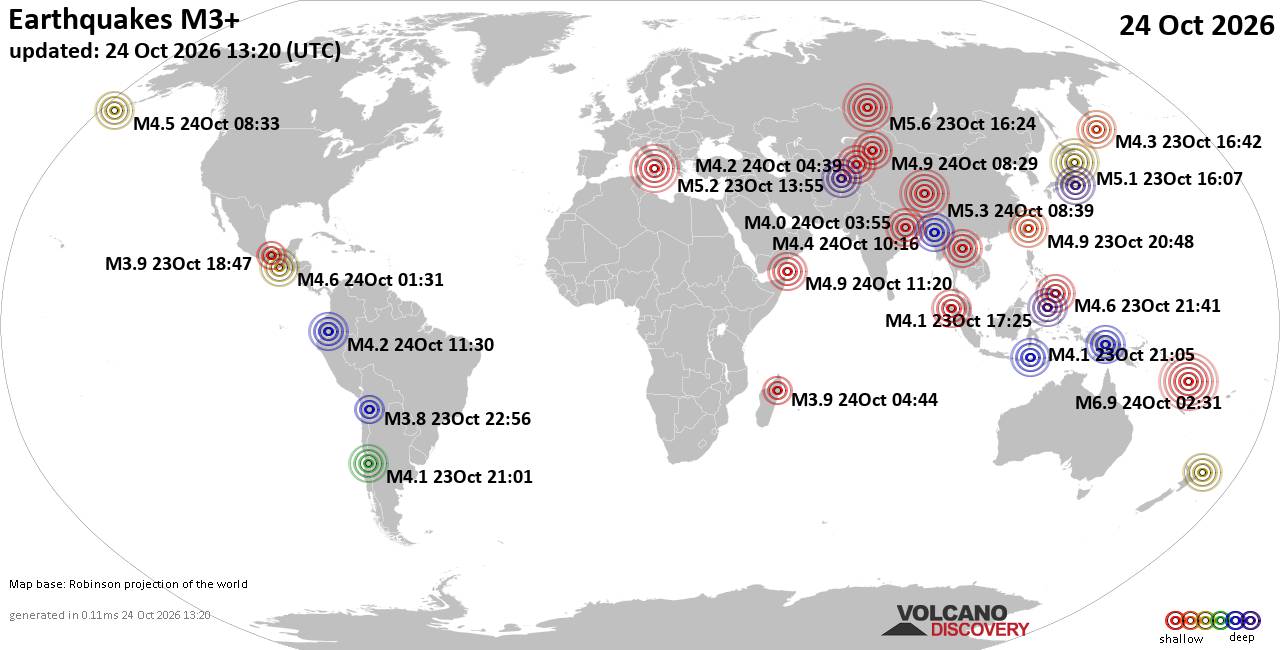
World Earthquake Report for Saturday, 24 October 2026
• M 1.9 - 47 km ENE of Pedro Bay, Alaska
• M 0.5 - 8 km SSW of Idyllwild, CA
• M 0.4 - 7 km SSW of Idyllwild, CA
• M 0.4 - 9 km N of Warner Springs, CA
• M 4.2 - 22 km ENE of Palora, Ecuador
|

#903621
Sat 10 Oct 2026 02:50:AM
|
Joined: Feb 2001
Posts: 678,977
Launch Director
|
|
Launch Director
Joined: Feb 2001
Posts: 678,977 |
Issued at 800 PM PDT Fri Oct 09 2026 000
WTPZ43 KNHC 100250
TCDEP3
Tropical Storm Rachel Discussion Number 52
NWS National Hurricane Center Miami FL EP182026
800 PM PDT Fri Oct 09 2026
Rachel has begun accelerating toward the northeast this evening.
After a day or two of relatively unimpressive convection, shower and
thunderstorm activity has increased near and east of the center,
with cold cloud top temperatures below -65 C. However, dry mid-level
air and moderate southwesterly wind shear continue to inhibit the
development of organized deep convection around the center. Recent
objective and subjective Dvorak intensity estimates range from 33-42
kt. The intensity is maintained at 40 kt for this advisory.
The tropical storm is moving northeastward, or 50/08 kt. Rachel is
positioned to the southeast of a strengthening closed mid-level low
moving southeastward off the coast of California. A rapid
acceleration toward the northeast then north-northeast is expected
over the next 24-36 h as the low rounds the base of the trough. This
motion should bring Rachel inland over northern Baja California late
Saturday or early Sunday. Interaction with the low will subject
Rachel to considerable wind shear, likely causing the low- and
mid-level centers to decouple. The low-level center is likely to
disintegrate as it encounters the Peninsular Ranges of northern
Baja, while the mid-level center continues northeastward into the
southwestern U.S. Track guidance remains similar to the previous
cycle, with the hurricane regional models, the GFS, and the ECMWF on
the left side of the envelope, and the GDMI and HCCA on the right.
However, the spread is beginning to narrow, with guidance
increasingly converging on landfall location in northern Baja. The
latest NHC track forecast is very similar to the previous advisory,
and lies near the middle of the guidance.
A modest increase in intensity is expected over the next 24 h as
Rachel interacts with the closed low, which will likely provide
favorable upper-level dynamics and an increase in mid-level
moisture. In addition, anomalously warm waters prevail offshore of
Baja California. Rachel is forecast to strengthen into a strong
tropical storm up through landfall, despite a significant increase
in wind shear. After landfall, Rachel is expected to weaken rapidly
as it moves inland and encounters the mountainous terrain, while the
mid-level low continues into the southwestern U.S. Strong, gusty
downslope winds may develop in the lee of the mountain ranges and
extend into the deserts. However, Rachel is forecast to lose its
tropical characteristics shortly after landfall. The latest NHC
forecast intensity is near the middle of the guidance envelope.
Key Messages:
1. Rachel is expected to approach the coast of the northern Baja
California Peninsula and extreme Southern California at tropical
storm strength Saturday night. Tropical storm conditions are
expected over portions of northern Baja California, Mexico where
Tropical Storm Warnings are in effect. Tropical storm conditions are
possible in extreme Southern California, eastern Baja California
and portions of northwest Mexico where a Tropical Storm Watch is in
effect.
2. Damaging wind gusts associated with Rachel and its remnants are
expected to spread over portions of northwestern Mexico and interior
portions of the Southwest United States, especially in areas of
higher terrain, Saturday night and Sunday.
3. Rachel and its moisture will spread over portions of the
Southwest United States and northern Baja California peninsula
through this weekend. This will lead to increasing coverage of
rainfall and for the potential for significant flash and urban
flooding.
4. Swells partly generated by Rachel will continue to build along
the coast of Southern California and northern Baja California.
These swells are likely to cause life-threatening surf and rip
current conditions, as well as moderate to isolated major coastal
flooding, through early next week. Please consult products from
your local weather office.
FORECAST POSITIONS AND MAX WINDS
INIT 10/0300Z 23.8N 123.3W 40 KT 45 MPH
12H 10/1200Z 25.3N 121.0W 45 KT 50 MPH
24H 11/0000Z 28.9N 118.1W 50 KT 60 MPH
36H 11/1200Z 33.9N 116.0W 40 KT 45 MPH...POST-TROP/INLAND
48H 12/0000Z...DISSIPATED
$$
Forecaster Adams Source: Tropical Storm Rachel Forecast Discussion Number 52
|
|



CMS The Best Conveyancing solicitors conveyancing quotes throughout the UK
For any webhosting enquiries please email webmaster@aus-city.com
|
|
Forums60
Topics892,112
Posts926,909
Members2,960
| |
Most Online102,106
Jul 10th, 2026
|
|
|









































