|
0 members (),
2,127
guests, and
27
robots. |
|
Key:
Admin,
Global Mod,
Mod
|
|
S |
M |
T |
W |
T |
F |
S |
|
|
|
|
|
1
|
2
|
3
|
|
4
|
5
|
6
|
7
|
8
|
9
|
10
|
|
11
|
12
|
13
|
14
|
15
|
16
|
17
|
|
18
|
19
|
20
|
21
|
22
|
23
|
24
|
|
25
|
26
|
27
|
28
|
29
|
30
|
31
|
|
There are no members with birthdays on this day. |
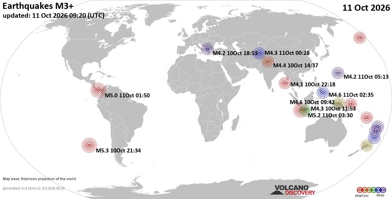
World Earthquake Report for Sunday, 11 October 2026
• M 4.0 - 56 km S of Whites City, New Mexico
• M 3.1 - 4 km E of San Jacinto, CA
• M 1.7 - 17 km WSW of Olancha, CA
• M 4.1 - 20 km W of Preston, Nevada
• M 7.7 - 12 km WSW of Pitaloza Arriba, Panama
|
|
|
Joined: Feb 2001
Posts: 678,977
Launch Director
|
|
Launch Director
Joined: Feb 2001
Posts: 678,977 |
Issued at 300 AM CST Sun Oct 11 2026 480
WTPZ45 KNHC 110859
TCDEP5
Hurricane Simon Discussion Number 16
NWS National Hurricane Center Miami FL EP202026
300 AM CST Sun Oct 11 2026
The Air Force Reserve Hurricane Hunters provided some valuable
information on the structure of Simon overnight. They found
that the pressure had dropped to 928 mb, with maximum flight-level
winds of 135 kt within the small inner core. Similar to the
afternoon flight, the whole wind field could not be observed. The
initial intensity is kept at 135 kt for this advisory as a blend of
the flight-level wind data, assuming a larger undersampling factor
than normal, with a slight weight on earlier experimental Synthetic
Aperture Radar (SAR) data, which showed category 5 strength.
The hurricane has turned north-northwest at about 5 kt. This
motion is expected to continue today, bringing the core of the
hurricane along the coast of southwestern Mexico. While some of
the models have shifted more offshore later today, it is simply too
close to call whether landfall will occur. Regardless of the exact
track, dangerous wind, surge, and rainfall effects appear likely
over portions of west-central Mexico today in the Hurricane Warning
area. After today, the model guidance is in poor agreement on what
happens due to a weak ridge building just north of the cyclone.
While the new forecast is nudged westward, it is east of the bulk
of the model guidance, and we are just going to have to wait and
see how much the high terrain of the Sierra Madre mountains affects
the hurricane before having any significant forecast confidence.
Some weakening should start soon due to the hurricane's close
proximity to land, and recent satellite imagery could be indicative
of that trend. However, Simon is still expected to be an extremely
dangerous hurricane as it passes near southwestern Mexico today.
The intensity forecast is extremely sensitive to how close Simon
passes to western Mexico during the next day or so. With the
forecast shifting somewhat offshore in a day or two, the weakening
rate is lowered some from the last advisory. This is a very low
confidence forecast because only a small deviation either east or
west could result in the hurricane rapidly dissipating after
landfall or keeping more strength offshore.
Key Messages:
1. Catastrophic wind and life-threatening storm surge impacts are
likely along a portion of the west-central coast of Mexico, and a
Hurricane Warning is in effect from Punta San Telmo to El Roblito.
Preparations to protect life and property should be rushed to
completion.
2. Heavy rainfall associated with Simon will impact portions of
southwestern Mexico through this weekend. This rainfall will produce
life-threatening flooding and mudslides, especially in areas of
steep terrain.
3. Swells will affect portions of the southwestern and west-central
coast of Mexico over the next few days. These swells are likely to
cause life-threatening surf and rip current conditions. Please
consult products from your local weather office.
FORECAST POSITIONS AND MAX WINDS
INIT 11/0900Z 18.7N 105.2W 135 KT 155 MPH...NEAR COAST
12H 11/1800Z 19.5N 105.4W 125 KT 145 MPH...NEAR COAST
24H 12/0600Z 20.5N 105.7W 90 KT 105 MPH...NEAR COAST
36H 12/1800Z 21.2N 106.0W 75 KT 85 MPH
48H 13/0600Z 22.0N 106.3W 50 KT 60 MPH
60H 13/1800Z 23.2N 106.2W 35 KT 40 MPH...INLAND
72H 14/0600Z...DISSIPATED
$$
Forecaster Blake Source: Hurricane Simon Forecast Discussion Number 16
|
|



CMS The Best Conveyancing solicitors conveyancing quotes throughout the UK
For any webhosting enquiries please email webmaster@aus-city.com
|
|
Forums60
Topics868,784
Posts903,580
Members2,960
| |
Most Online102,106
Jul 10th, 2026
|
|
|









































